The WF2 7 postcode sector is within the county of West Yorkshire.
Did you know? According to the 2021 Census, the WF2 7 postcode sector is home to a bustling 8,569 residents!
Given that each sector allows for 400 unique postcode combinations. Letters C, I, K, M, O and V are not allowed in the last two letters of a postcode. With 226 postcodes already in use, this leaves 174 units available.
The largest settlement in the WF2 7 postal code is WAKEFIELD followed by Newmillerdam, and Milnthorpe.
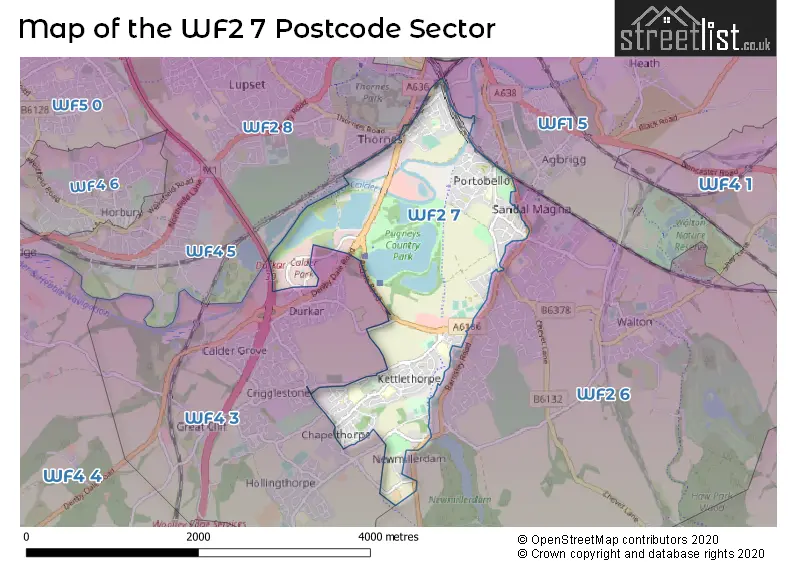
The WF2 7 Postcode shares a border with WF1 5 (WAKEFIELD, Kirkthorpe, Heath), WF2 6 (WAKEFIELD, Walton, Newmillerdam), WF2 8 (WAKEFIELD), WF4 3 (Crigglestone, Durkar, Hall Green) and WF4 5 (Horbury).
The sector is within the post town of WAKEFIELD.
WF2 7 is a postcode sector within the WF2 postcode district which is within the WF Wakefield postcode area.
The Royal Mail delivery office for the WF2 7 postal sector is the Wakefield Delivery Office.
The area of the WF2 7 postcode sector is 2.34 square miles which is 6.06 square kilometres or 1,496.97 square acres.
The WF2 7 postcode sector is crossed by the M1 motorway.
Waterways within the WF2 7 postcode sector include the River Calder.

Map of the WF2 7 Postcode Sector
Explore the WF2 7 postcode sector by using our free interactive map.
| W | F | 2 | - | 7 | X | X |
| W | F | 2 | Space | 7 | Letter | Letter |
Official List of Streets
WAKEFIELD (114 Streets)
Newmillerdam (10 Streets)
Milnthorpe (2 Streets)
Unofficial Streets or Alternative Spellings
WAKEFIELD
BETHEL PLACE CASTLE TERRACE COTTON STREET SANDAL CLIFF TADMAN STREET THORNES LANE WHARF WALTON LANE AVENUE ROAD CLARENCE ROAD FAWCETT STREET FISHPOND LANE GATE FIELD CLOSE HOLME LANE HOLMEFIELD AVENUE HOLMEFIELD GROVE NAVIGATION COURT SHAWFOLD SHERWOOD COURT VERNON PLACE WADHOUSE LANEChapelthorpe
BOYNE HILL CHURCH LANE WOOD LANENewmillerdam
BARNSLEY ROAD MILL FARM DRIVECrigglestone
BULL LANE FISHPONDS DRIVE HAVEROID LANE HIGH STREET STANDBRIDGE LANEDurkar
DURKAR LOW LANE THOMAS MADDISON LANECalder Grove
DENBY DALE ROADWeather Forecast for WF2 7
Press Button to Show Forecast for Sandal Magna
| Time Period | Icon | Description | Temperature | Rain Probability | Wind |
|---|---|---|---|---|---|
| 18:00 to 21:00 | Cloudy | 8.0°C (feels like 6.0°C) | 6.00% | NNE 7 mph | |
| 21:00 to 00:00 | Partly cloudy (night) | 5.0°C (feels like 3.0°C) | 2.00% | NE 7 mph |
Press Button to Show Forecast for Sandal Magna
| Time Period | Icon | Description | Temperature | Rain Probability | Wind |
|---|---|---|---|---|---|
| 00:00 to 03:00 | Clear night | 3.0°C (feels like 1.0°C) | 2.00% | NNE 2 mph | |
| 03:00 to 06:00 | Clear night | 2.0°C (feels like 0.0°C) | 1.00% | NNW 4 mph | |
| 06:00 to 09:00 | Partly cloudy (day) | 3.0°C (feels like 1.0°C) | 2.00% | NNW 4 mph | |
| 09:00 to 12:00 | Cloudy | 7.0°C (feels like 5.0°C) | 5.00% | ENE 4 mph | |
| 12:00 to 15:00 | Overcast | 8.0°C (feels like 7.0°C) | 11.00% | E 4 mph | |
| 15:00 to 18:00 | Cloudy | 9.0°C (feels like 8.0°C) | 7.00% | ENE 4 mph | |
| 18:00 to 21:00 | Partly cloudy (day) | 8.0°C (feels like 6.0°C) | 6.00% | E 7 mph | |
| 21:00 to 00:00 | Cloudy | 5.0°C (feels like 2.0°C) | 6.00% | E 4 mph |
Press Button to Show Forecast for Sandal Magna
| Time Period | Icon | Description | Temperature | Rain Probability | Wind |
|---|---|---|---|---|---|
| 00:00 to 03:00 | Cloudy | 4.0°C (feels like 2.0°C) | 7.00% | NNE 4 mph | |
| 03:00 to 06:00 | Cloudy | 3.0°C (feels like 1.0°C) | 7.00% | NE 4 mph | |
| 06:00 to 09:00 | Partly cloudy (day) | 3.0°C (feels like 1.0°C) | 7.00% | NE 4 mph | |
| 09:00 to 12:00 | Cloudy | 8.0°C (feels like 6.0°C) | 10.00% | E 7 mph | |
| 12:00 to 15:00 | Overcast | 10.0°C (feels like 8.0°C) | 17.00% | E 9 mph | |
| 15:00 to 18:00 | Cloudy | 10.0°C (feels like 8.0°C) | 18.00% | E 9 mph | |
| 18:00 to 21:00 | Cloudy | 9.0°C (feels like 6.0°C) | 17.00% | ENE 11 mph | |
| 21:00 to 00:00 | Cloudy | 6.0°C (feels like 4.0°C) | 15.00% | NE 7 mph |
Press Button to Show Forecast for Sandal Magna
| Time Period | Icon | Description | Temperature | Rain Probability | Wind |
|---|---|---|---|---|---|
| 00:00 to 03:00 | Cloudy | 6.0°C (feels like 3.0°C) | 20.00% | NNE 9 mph | |
| 03:00 to 06:00 | Light rain | 6.0°C (feels like 3.0°C) | 49.00% | NNE 11 mph | |
| 06:00 to 09:00 | Light rain | 7.0°C (feels like 3.0°C) | 52.00% | NNE 11 mph | |
| 09:00 to 12:00 | Heavy rain | 8.0°C (feels like 5.0°C) | 79.00% | NNE 13 mph | |
| 12:00 to 15:00 | Heavy rain | 9.0°C (feels like 6.0°C) | 76.00% | NNE 13 mph | |
| 15:00 to 18:00 | Light rain shower (day) | 9.0°C (feels like 7.0°C) | 44.00% | N 11 mph | |
| 18:00 to 21:00 | Cloudy | 9.0°C (feels like 8.0°C) | 16.00% | NNE 7 mph | |
| 21:00 to 00:00 | Partly cloudy (night) | 7.0°C (feels like 5.0°C) | 9.00% | SE 7 mph |
Schools and Places of Education Within the WF2 7 Postcode Sector
Hendal Primary School
Community school
Hendal Lane, Wakefield, West Yorkshire, WF2 7QW
Head: Mrs Kelly Ashton
Ofsted Rating: Good
Inspection: 2020-03-11 (1506 days ago)
Website: Visit Hendal Primary School Website
Phone: 01924259465
Number of Pupils: 416
Kettlethorpe High School
Community school
Kettlethorpe Hall Drive, Wakefield, West Yorkshire, WF2 7EL
Head: Mr Tudor Griffiths
Ofsted Rating: Good
Inspection: 2022-06-15 (680 days ago)
Website: Visit Kettlethorpe High School Website
Phone: 01924251605
Number of Pupils: 1646
Methodist Voluntary Controlled Junior, Infant and Nursery School: With Communication Resource
Voluntary controlled school
Field Lane, Wakefield, West Yorkshire, WF2 7RU
Head: Mrs Donna Clark
Ofsted Rating: Good
Inspection: 2023-07-13 (287 days ago)
Website: Visit Methodist Voluntary Controlled Junior, Infant and Nursery School: With Communication Resource Website
Phone: 01924204940
Number of Pupils: 240
House Prices in the WF2 7 Postcode Sector
| Type of Property | 2018 Average | 2018 Sales | 2017 Average | 2017 Sales | 2016 Average | 2016 Sales | 2015 Average | 2015 Sales |
|---|---|---|---|---|---|---|---|---|
| Detached | £332,261 | 42 | £332,066 | 40 | £308,865 | 43 | £307,584 | 28 |
| Semi-Detached | £151,157 | 52 | £155,671 | 50 | £150,659 | 75 | £121,161 | 73 |
| Terraced | £128,443 | 14 | £125,132 | 19 | £123,153 | 24 | £92,614 | 30 |
| Flats | £0 | 0 | £133,333 | 3 | £127,450 | 2 | £67,000 | 1 |
Important Postcodes WF2 7 in the Postcode Sector
WF2 7DQ is the postcode for Manygates Adult Education Centre, 24-26 Manygates Lane, and Wakefield Music Services, Manygates Adult Education Centre 24-26, Manygates Lane
WF2 7EL is the postcode for MAIN, Kettlethorpe High School, Kettlethorpe Hall Drive, SPORTS HALL, Kettlethorpe High School, Kettlethorpe Hall Drive, and Kettlethorpe High School, Kettlethorpe Hall Drive
WF2 7EQ is the postcode for Pugneys Country Park Building, Leisure & Sailing Centre
WF2 7GP is the postcode for Chapelthorpe Medical Centre, Standbridge Lane
WF2 7JE is the postcode for Sandal Medical Centre, Sandal Castle Centre, Asdale Road
WF2 7LN is the postcode for Castle Grove Infant School, Pinfold Lane
WF2 7QW is the postcode for Hendal Primary Junior Infant & Nursery School, Hendal Lane
WF2 7RU is the postcode for METHODIST JUNIOR AND INFANT SCHOOL, FIELD LANE, WAKEFIELD, and Methodist Junior & Infant School, Field Lane
WF2 7UA is the postcode for Honda, Peel Avenue, Kia, Peel Avenue, and The Highways Agency, Kestrel House, Peel Avenue
| The WF2 7 Sector is within these Local Authorities |
|
|---|---|
| The WF2 7 Sector is within these Counties |
|
| The WF2 7 Sector is within these Water Company Areas |
|