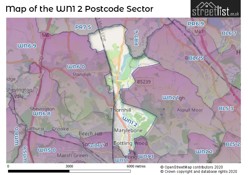
The WN1 2 postcode sector stands on the Greater Manchester and Lancashire border.
Did you know? According to the 2021 Census, the WN1 2 postcode sector is home to a bustling 9,539 residents!
Given that each sector allows for 400 unique postcode combinations. Letters C, I, K, M, O and V are not allowed in the last two letters of a postcode. With 244 postcodes already in use, this leaves 156 units available.
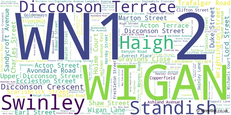
The largest settlement in the WN1 2 postal code is WIGAN followed by Standish, and Haigh.
The WN1 2 Postcode shares a border with WN1 3 (WIGAN, Ince), WN6 7 (WIGAN), BL6 5 (Blackrod, Horwich), PR7 4 (Coppull, Adlington, CHORLEY), PR7 5 (Coppull, Eccleston, Charnock Richard), WN1 1 (WIGAN), WN2 1 (Aspull, WIGAN, Haigh), WN6 0 (Standish) and WN6 8 (Shevington, WIGAN, Standish Lower Ground).
The sector is within the post town of WIGAN.
WN1 2 is a postcode sector within the WN1 postcode district which is within the WN Wigan postcode area.
The Royal Mail delivery office for the WN1 2 postal sector is the Wigan Delivery Office.
The area of the WN1 2 postcode sector is 3.37 square miles which is 8.74 square kilometres or 2,158.96 square acres.
Waterways within the WN1 2 postcode sector include the Leeds and Liverpool Canal.

Map of the WN1 2 Postcode Sector
Explore the WN1 2 postcode sector by using our free interactive map.
| W | N | 1 | - | 2 | X | X |
| W | N | 1 | Space | 2 | Letter | Letter |
Official List of Streets
WIGAN (123 Streets)
Standish (33 Streets)
Haigh (2 Streets)
Swinley (2 Streets)
Unofficial Streets or Alternative Spellings
WIGAN
BRICK KILN LANE BRIDGEMAN TERRACE BUCKLEY STREET MARYLEBONE COURT SPENCER ROAD WEST STANDISHGATEHaigh
CANAL ROW SENNICAR LANEStandish
DELFHAVEN COURTCoppull
WIGAN LANE BELLINGHAM MOUNT BORES HILL CENTRAL PARK WAY CHERRY GARDENS ROUNDABOUT LITTLE LONDON MOSS GREEN CLOSE OLD LANE SICKLEFIELD STANDISH JUNCTION LINEBlackrod
BLUNDELL LANEWeather Forecast for WN1 2
Press Button to Show Forecast for Standish
| Time Period | Icon | Description | Temperature | Rain Probability | Wind |
|---|---|---|---|---|---|
| 12:00 to 15:00 | Cloudy | 11.0°C (feels like 8.0°C) | 51.00% | NW 16 mph | |
| 15:00 to 18:00 | Cloudy | 10.0°C (feels like 8.0°C) | 38.00% | N 11 mph | |
| 18:00 to 21:00 | Partly cloudy (day) | 10.0°C (feels like 8.0°C) | 3.00% | NNW 9 mph | |
| 21:00 to 00:00 | Partly cloudy (night) | 7.0°C (feels like 6.0°C) | 1.00% | NE 4 mph |
Press Button to Show Forecast for Standish
| Time Period | Icon | Description | Temperature | Rain Probability | Wind |
|---|---|---|---|---|---|
| 00:00 to 03:00 | Clear night | 4.0°C (feels like 3.0°C) | 0.00% | ENE 4 mph | |
| 03:00 to 06:00 | Clear night | 3.0°C (feels like 2.0°C) | 0.00% | N 2 mph | |
| 06:00 to 09:00 | Partly cloudy (day) | 4.0°C (feels like 3.0°C) | 0.00% | ENE 2 mph | |
| 09:00 to 12:00 | Sunny day | 7.0°C (feels like 7.0°C) | 1.00% | NNW 4 mph | |
| 12:00 to 15:00 | Cloudy | 10.0°C (feels like 9.0°C) | 4.00% | NNW 7 mph | |
| 15:00 to 18:00 | Cloudy | 11.0°C (feels like 9.0°C) | 5.00% | NW 9 mph | |
| 18:00 to 21:00 | Partly cloudy (day) | 9.0°C (feels like 7.0°C) | 1.00% | NW 9 mph | |
| 21:00 to 00:00 | Partly cloudy (night) | 7.0°C (feels like 5.0°C) | 0.00% | NNW 4 mph |
Press Button to Show Forecast for Standish
| Time Period | Icon | Description | Temperature | Rain Probability | Wind |
|---|---|---|---|---|---|
| 00:00 to 03:00 | Cloudy | 6.0°C (feels like 4.0°C) | 4.00% | NE 4 mph | |
| 03:00 to 06:00 | Overcast | 5.0°C (feels like 4.0°C) | 12.00% | E 4 mph | |
| 06:00 to 09:00 | Light rain | 6.0°C (feels like 4.0°C) | 51.00% | E 4 mph | |
| 09:00 to 12:00 | Cloudy | 7.0°C (feels like 5.0°C) | 16.00% | ENE 7 mph | |
| 12:00 to 15:00 | Cloudy | 9.0°C (feels like 8.0°C) | 14.00% | ENE 7 mph | |
| 15:00 to 18:00 | Cloudy | 11.0°C (feels like 10.0°C) | 7.00% | NE 7 mph | |
| 18:00 to 21:00 | Cloudy | 10.0°C (feels like 9.0°C) | 8.00% | NE 7 mph | |
| 21:00 to 00:00 | Cloudy | 7.0°C (feels like 6.0°C) | 8.00% | ENE 4 mph |
Press Button to Show Forecast for Standish
| Time Period | Icon | Description | Temperature | Rain Probability | Wind |
|---|---|---|---|---|---|
| 00:00 to 03:00 | Overcast | 6.0°C (feels like 5.0°C) | 10.00% | ESE 4 mph | |
| 03:00 to 06:00 | Overcast | 6.0°C (feels like 4.0°C) | 12.00% | S 4 mph | |
| 06:00 to 09:00 | Overcast | 6.0°C (feels like 4.0°C) | 13.00% | S 4 mph | |
| 09:00 to 12:00 | Light rain | 8.0°C (feels like 6.0°C) | 43.00% | SW 7 mph | |
| 12:00 to 15:00 | Cloudy | 10.0°C (feels like 8.0°C) | 14.00% | SSW 9 mph | |
| 15:00 to 18:00 | Overcast | 11.0°C (feels like 9.0°C) | 17.00% | NE 9 mph | |
| 18:00 to 21:00 | Cloudy | 10.0°C (feels like 9.0°C) | 13.00% | NE 7 mph | |
| 21:00 to 00:00 | Cloudy | 9.0°C (feels like 8.0°C) | 13.00% | NE 4 mph |
Press Button to Show Forecast for Standish
| Time Period | Icon | Description | Temperature | Rain Probability | Wind |
|---|---|---|---|---|---|
| 00:00 to 03:00 | Cloudy | 8.0°C (feels like 7.0°C) | 7.00% | NE 7 mph | |
| 03:00 to 06:00 | Cloudy | 6.0°C (feels like 4.0°C) | 6.00% | E 7 mph | |
| 06:00 to 09:00 | Overcast | 6.0°C (feels like 4.0°C) | 9.00% | NNE 7 mph | |
| 09:00 to 12:00 | Cloudy | 9.0°C (feels like 6.0°C) | 6.00% | NE 9 mph | |
| 12:00 to 15:00 | Cloudy | 10.0°C (feels like 8.0°C) | 7.00% | NNE 9 mph | |
| 15:00 to 18:00 | Overcast | 11.0°C (feels like 9.0°C) | 10.00% | NNE 9 mph | |
| 18:00 to 21:00 | Cloudy | 10.0°C (feels like 9.0°C) | 6.00% | NNE 7 mph | |
| 21:00 to 00:00 | Partly cloudy (night) | 8.0°C (feels like 6.0°C) | 2.00% | NNE 7 mph |
Schools and Places of Education Within the WN1 2 Postcode Sector
Woodfield Primary School
Community school
Wigan Lane, Wigan, Lancashire, WN1 2NT
Head: Miss Anna Prior
Ofsted Rating: Outstanding
Inspection: 2014-10-22 (3467 days ago)
Website: Visit Woodfield Primary School Website
Phone: 01942243675
Number of Pupils: 208
House Prices in the WN1 2 Postcode Sector
| Type of Property | 2018 Average | 2018 Sales | 2017 Average | 2017 Sales | 2016 Average | 2016 Sales | 2015 Average | 2015 Sales |
|---|---|---|---|---|---|---|---|---|
| Detached | £322,241 | 40 | £396,643 | 28 | £343,554 | 26 | £340,468 | 38 |
| Semi-Detached | £189,659 | 87 | £178,593 | 75 | £184,924 | 78 | £181,915 | 75 |
| Terraced | £144,896 | 51 | £160,745 | 52 | £157,842 | 48 | £174,494 | 40 |
| Flats | £109,028 | 18 | £104,772 | 33 | £108,083 | 24 | £117,732 | 14 |
Important Postcodes WN1 2 in the Postcode Sector
WN1 2JH is the postcode for Wigan & Leigh College, Pagefield Campus, Walkden Avenue
WN1 2NN is the postcode for Nurses Home / Administration Office Block 8, Wrightington, Wigan and Leigh NHS Trust, Royal Albert Edward Infirmary, MAIN HOSPITAL SITE BLOCKS 38,48-50, Wrightington, Wigan and Leigh NHS Trust, Royal Albert Edward Infirmary, Highfield / Upper Johnson Wing Block 10, Wrightington, Wigan and Leigh NHS Trust, Royal Albert Edward Infirmary, ELMS TEACHING DEPARTMENT BLOCK 25, Wrightington, Wigan and Leigh NHS Trust, Royal Albert Edward Infirmary, CAU Block 71, Wrightington, Wigan and Leigh NHS Trust, Royal Albert Edward Infirmary, NURSES HOME/ ADMINISTRATION OFFICE BLOCK 8, Wrightington, Wigan and Leigh NHS Trust, Royal Albert Edward Infirmary, MEDICAL RECORDS, Wrightington, Wigan and Leigh NHS Trust, Royal Albert Edward Infirmary, HIGHFIELD/UPPER JOHNSON WING BLOCK 10, Wrightington, Wigan and Leigh NHS Trust, Royal Albert Edward Infirmary, Medical Education Centre Block 35, Wrightington, Wigan and Leigh NHS Trust, Royal Albert Edward Infirmary, MEDICAL ASSESSMENT UNIT AND CHAPEL BLOCKS 6 AND 7, Wrightington, Wigan and Leigh NHS Trust, Royal Albert Edward Infirmary, MAIN ENTRANCE BLOCK 18, Wrightington, Wigan and Leigh NHS Trust, Royal Albert Edward Infirmary, LABORATORY BLOCK 23, Wrightington, Wigan and Leigh NHS Trust, Royal Albert Edward Infirmary, Main Entrance Chapel and Kitchen Block 6,7,16,17,18, Wrightington, Wigan and Leigh NHS Trust, Royal Albert Edward Infirmary, Wrightington, Wigan and Leigh NHS Trust, Royal Albert Edward Infirmary, Main Hospital Site Blocks 38, 48-50, Wrightington, Wigan and Leigh NHS Trust, Royal Albert Edward Infirmary, and CHRISTOPHER HOME WING BLOCK 24, Wrightington, Wigan and Leigh NHS Trust, Royal Albert Edward Infirmary
WN1 2NT is the postcode for Woodfield Community Primary School, Wigan Lane
| The WN1 2 Sector is within these Local Authorities |
|
|---|---|
| The WN1 2 Sector is within these Counties |
|
| The WN1 2 Sector is within these Water Company Areas |
|