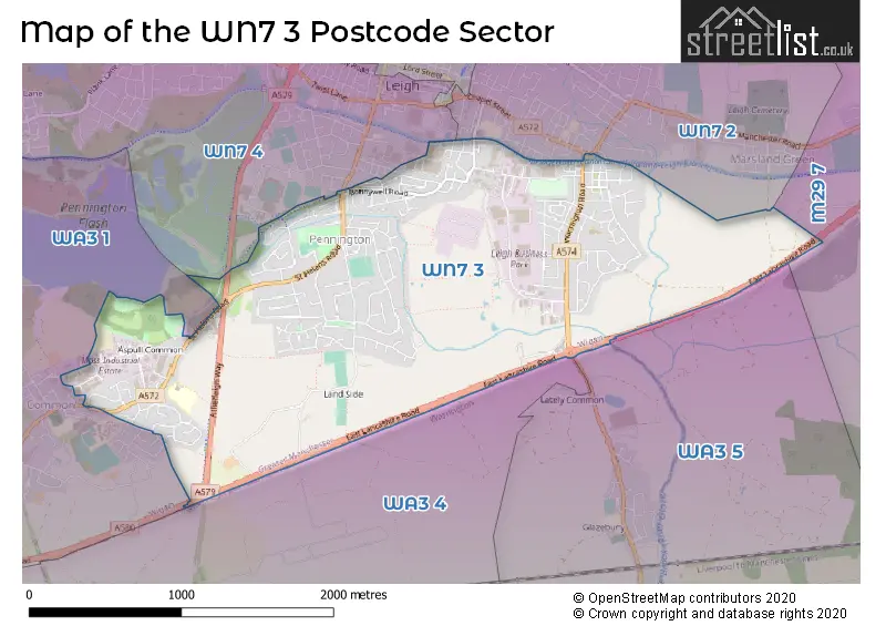
The WN7 3 postcode sector stands on the Cheshire and Greater Manchester border.
Did you know? According to the 2021 Census, the WN7 3 postcode sector is home to a bustling 10,069 residents!
Given that each sector allows for 400 unique postcode combinations. Letters C, I, K, M, O and V are not allowed in the last two letters of a postcode. With 218 postcodes already in use, this leaves 182 units available.
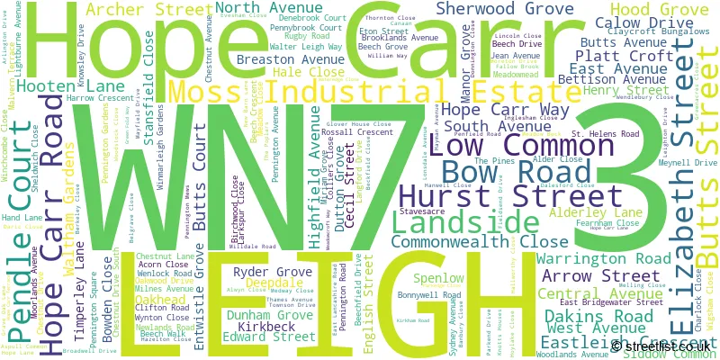
The largest settlement in the WN7 3 postal code is LEIGH followed by Moss Industrial Estate, and Hope Carr.
The WN7 3 Postcode shares a border with WA3 1 (Lowton), WA3 4 (Culcheth, Kenyon, Glazebury), WA3 5 (Culcheth, Glazebury, Glazebrook), WN7 2 (LEIGH), WN7 4 (LEIGH) and M29 7 (Tyldesley).
The sector is within the post town of LEIGH.
WN7 3 is a postcode sector within the WN7 postcode district which is within the WN Wigan postcode area.
The Royal Mail delivery office for the WN7 3 postal sector is the Leigh Delivery Office.
The area of the WN7 3 postcode sector is 2.20 square miles which is 5.69 square kilometres or 1,406.03 square acres.
Waterways within the WN7 3 postcode sector include the Bridgewater Canal.

Map of the WN7 3 Postcode Sector
Explore the WN7 3 postcode sector by using our free interactive map.
| W | N | 7 | - | 3 | X | X |
| W | N | 7 | Space | 3 | Letter | Letter |
Official List of Streets
LEIGH (153 Streets)
Low Common (2 Streets)
Hope Carr (2 Streets)
Moss Industrial Estate (2 Streets)
Unofficial Streets or Alternative Spellings
LEIGH
ATHERLEIGH WAY BUCK STREET CHAPEL STREET FORTH STREET MATHER LANELowton
ABBEY ROAD CANAAN CLAYHILL GROVE NEWTON ROADGlazebury
EAST LANCASHIRE ROAD ACORN COURT ANCHOR FIELD ASPULL COURT BACK HURST STREET CARR LANE CLAY CROFT CROFT COURT DERWENT WAY DICK MATHER BRIDGE DOUGLAS WAY GREEN COURT GREENFOLD COURT GREYHOUND ISLAND HURSTWOOD COURT KENYON COURT KNOTTS HOUSES LOW COMMON NORTH BUTTS STREET NORWEB WAY ORFORD COURT ORFORD PARK PENNINGTON COURT REGENCY WHARF RIVINGTON COURT THE DRIVEBirchwood
WARRINGTON ROADWeather Forecast for WN7 3
Press Button to Show Forecast for Leigh
| Time Period | Icon | Description | Temperature | Rain Probability | Wind |
|---|---|---|---|---|---|
| 15:00 to 18:00 | Cloudy | 9.0°C (feels like 9.0°C) | 34.00% | NNW 4 mph | |
| 18:00 to 21:00 | Cloudy | 9.0°C (feels like 7.0°C) | 45.00% | N 7 mph | |
| 21:00 to 00:00 | Cloudy | 6.0°C (feels like 5.0°C) | 7.00% | ESE 4 mph |
Press Button to Show Forecast for Leigh
| Time Period | Icon | Description | Temperature | Rain Probability | Wind |
|---|---|---|---|---|---|
| 00:00 to 03:00 | Cloudy | 5.0°C (feels like 3.0°C) | 5.00% | ENE 7 mph | |
| 03:00 to 06:00 | Partly cloudy (night) | 3.0°C (feels like 1.0°C) | 1.00% | ENE 4 mph | |
| 06:00 to 09:00 | Partly cloudy (day) | 4.0°C (feels like 2.0°C) | 1.00% | ENE 4 mph | |
| 09:00 to 12:00 | Partly cloudy (day) | 7.0°C (feels like 6.0°C) | 2.00% | E 4 mph | |
| 12:00 to 15:00 | Cloudy | 9.0°C (feels like 8.0°C) | 9.00% | E 4 mph | |
| 15:00 to 18:00 | Cloudy | 10.0°C (feels like 9.0°C) | 7.00% | ENE 4 mph | |
| 18:00 to 21:00 | Cloudy | 10.0°C (feels like 9.0°C) | 7.00% | ENE 4 mph | |
| 21:00 to 00:00 | Partly cloudy (night) | 6.0°C (feels like 4.0°C) | 4.00% | ENE 7 mph |
Press Button to Show Forecast for Leigh
| Time Period | Icon | Description | Temperature | Rain Probability | Wind |
|---|---|---|---|---|---|
| 00:00 to 03:00 | Clear night | 4.0°C (feels like 2.0°C) | 5.00% | ENE 4 mph | |
| 03:00 to 06:00 | Partly cloudy (night) | 3.0°C (feels like 1.0°C) | 6.00% | ENE 4 mph | |
| 06:00 to 09:00 | Cloudy | 5.0°C (feels like 3.0°C) | 9.00% | ENE 7 mph | |
| 09:00 to 12:00 | Partly cloudy (day) | 8.0°C (feels like 6.0°C) | 5.00% | E 7 mph | |
| 12:00 to 15:00 | Overcast | 10.0°C (feels like 9.0°C) | 16.00% | E 7 mph | |
| 15:00 to 18:00 | Cloudy | 11.0°C (feels like 9.0°C) | 18.00% | ENE 9 mph | |
| 18:00 to 21:00 | Cloudy | 10.0°C (feels like 8.0°C) | 15.00% | ENE 9 mph | |
| 21:00 to 00:00 | Cloudy | 7.0°C (feels like 5.0°C) | 17.00% | NE 9 mph |
Press Button to Show Forecast for Leigh
| Time Period | Icon | Description | Temperature | Rain Probability | Wind |
|---|---|---|---|---|---|
| 00:00 to 03:00 | Cloudy | 6.0°C (feels like 4.0°C) | 16.00% | NE 9 mph | |
| 03:00 to 06:00 | Cloudy | 6.0°C (feels like 4.0°C) | 20.00% | NNE 9 mph | |
| 06:00 to 09:00 | Cloudy | 7.0°C (feels like 4.0°C) | 20.00% | NNE 9 mph | |
| 09:00 to 12:00 | Light rain | 8.0°C (feels like 5.0°C) | 50.00% | NNE 11 mph | |
| 12:00 to 15:00 | Heavy rain | 9.0°C (feels like 6.0°C) | 76.00% | N 11 mph | |
| 15:00 to 18:00 | Light rain | 10.0°C (feels like 7.0°C) | 57.00% | N 9 mph | |
| 18:00 to 21:00 | Cloudy | 10.0°C (feels like 8.0°C) | 18.00% | N 9 mph | |
| 21:00 to 00:00 | Clear night | 8.0°C (feels like 6.0°C) | 10.00% | NW 7 mph |
Schools and Places of Education Within the WN7 3 Postcode Sector
Bedford Hall Methodist Primary School
Academy converter
Breaston Avenue, Leigh, Lancashire, WN7 3DJ
Head: Mrs Lisa Draper
Ofsted Rating: Good
Inspection: 2022-12-07 (505 days ago)
Website: Visit Bedford Hall Methodist Primary School Website
Phone: 01942672614
Number of Pupils: 241
Gilded Hollins Community School
Community school
St Helen's Road, Leigh, Lancashire, WN7 3PQ
Head: Mrs Christine Burns
Ofsted Rating: Good
Inspection: 2023-07-13 (287 days ago)
Website: Visit Gilded Hollins Community School Website
Phone: 01942678903
Number of Pupils: 208
House Prices in the WN7 3 Postcode Sector
| Type of Property | 2018 Average | 2018 Sales | 2017 Average | 2017 Sales | 2016 Average | 2016 Sales | 2015 Average | 2015 Sales |
|---|---|---|---|---|---|---|---|---|
| Detached | £283,516 | 21 | £242,662 | 36 | £252,178 | 43 | £221,208 | 53 |
| Semi-Detached | £161,499 | 77 | £167,753 | 79 | £153,132 | 65 | £156,412 | 74 |
| Terraced | £94,920 | 61 | £84,340 | 43 | £106,670 | 40 | £92,782 | 47 |
| Flats | £80,917 | 6 | £60,250 | 3 | £91,500 | 3 | £92,055 | 9 |
Important Postcodes WN7 3 in the Postcode Sector
WN7 3DJ is the postcode for MAIN SCHOOL, Bedford Hall Methodist Primary School, Breaston Avenue, Bedford Hall Methodist Primary School, Breaston Avenue, and BEDFORD HALL METHODIST PRIMARY SCHOOL, BREASTON AVENUE, LEIGH
WN7 3PA is the postcode for Greater Manchester Fire & Rescue Service, Technical Services Centre, St. Helens Road, Greater Manchester Fire & Rescue Service, Fire Station, St. Helens Road, and Greater Manchester Fire & Rescue Service, Technical Services Centre
WN7 3PQ is the postcode for Gilded Hollins School, St. Helens Road
| The WN7 3 Sector is within these Local Authorities |
|
|---|---|
| The WN7 3 Sector is within these Counties |
|
| The WN7 3 Sector is within these Water Company Areas |
|