The WN7 5 postcode sector is within the county of Greater Manchester.
Did you know? According to the 2021 Census, the WN7 5 postcode sector is home to a bustling 11,723 residents!
Given that each sector allows for 400 unique postcode combinations. Letters C, I, K, M, O and V are not allowed in the last two letters of a postcode. With 245 postcodes already in use, this leaves 155 units available.
The WN7 5 postal code covers the settlement of LEIGH.
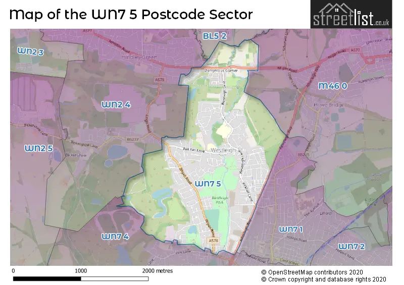
The WN7 5 Postcode shares a border with WN7 1 (LEIGH), WN7 4 (LEIGH), BL5 2 (Westhoughton), M46 0 (Atherton) and WN2 4 (Hindley Green, Hindley, Bickershaw).
The sector is within the post town of LEIGH.
WN7 5 is a postcode sector within the WN7 postcode district which is within the WN Wigan postcode area.
The Royal Mail delivery office for the WN7 5 postal sector is the Leigh Delivery Office.
The area of the WN7 5 postcode sector is 1.67 square miles which is 4.34 square kilometres or 1,071.41 square acres.
Waterways within the WN7 5 postcode sector include the Lee Hall Brook, Small Brook, Westleigh Brook.

Map of the WN7 5 Postcode Sector
Explore the WN7 5 postcode sector by using our free interactive map.
| W | N | 7 | - | 5 | X | X |
| W | N | 7 | Space | 5 | Letter | Letter |
Official List of Streets
LEIGH (189 Streets)
Unofficial Streets or Alternative Spellings
Atherton
WIGAN ROADLEIGH
ATHERLEIGH WAY LEIGH STREET NANGREAVES STREET WALMESLEY ROAD BACK MAPLE CRESCENT BANKS COURT BELL STREET BROOKS HOUSES HAMILTON STREET HAWTHORNE GROVE HAYES STREET STANHOPE STREET TAMAR GROVE WRAXHALL CRESCENTHindley Green
COLWYN DRIVE COUPLAND ROAD HARBROOK GROVE LEIGH ROADWeather Forecast for WN7 5
Press Button to Show Forecast for Leigh
| Time Period | Icon | Description | Temperature | Rain Probability | Wind |
|---|---|---|---|---|---|
| 15:00 to 18:00 | Cloudy | 9.0°C (feels like 9.0°C) | 34.00% | NNW 4 mph | |
| 18:00 to 21:00 | Cloudy | 9.0°C (feels like 7.0°C) | 45.00% | N 7 mph | |
| 21:00 to 00:00 | Cloudy | 6.0°C (feels like 5.0°C) | 7.00% | ESE 4 mph |
Press Button to Show Forecast for Leigh
| Time Period | Icon | Description | Temperature | Rain Probability | Wind |
|---|---|---|---|---|---|
| 00:00 to 03:00 | Cloudy | 5.0°C (feels like 3.0°C) | 5.00% | ENE 7 mph | |
| 03:00 to 06:00 | Partly cloudy (night) | 3.0°C (feels like 1.0°C) | 1.00% | ENE 4 mph | |
| 06:00 to 09:00 | Partly cloudy (day) | 4.0°C (feels like 2.0°C) | 1.00% | ENE 4 mph | |
| 09:00 to 12:00 | Partly cloudy (day) | 7.0°C (feels like 6.0°C) | 2.00% | E 4 mph | |
| 12:00 to 15:00 | Cloudy | 9.0°C (feels like 8.0°C) | 9.00% | E 4 mph | |
| 15:00 to 18:00 | Cloudy | 10.0°C (feels like 9.0°C) | 7.00% | ENE 4 mph | |
| 18:00 to 21:00 | Cloudy | 10.0°C (feels like 9.0°C) | 7.00% | ENE 4 mph | |
| 21:00 to 00:00 | Partly cloudy (night) | 6.0°C (feels like 4.0°C) | 4.00% | ENE 7 mph |
Press Button to Show Forecast for Leigh
| Time Period | Icon | Description | Temperature | Rain Probability | Wind |
|---|---|---|---|---|---|
| 00:00 to 03:00 | Clear night | 4.0°C (feels like 2.0°C) | 5.00% | ENE 4 mph | |
| 03:00 to 06:00 | Partly cloudy (night) | 3.0°C (feels like 1.0°C) | 6.00% | ENE 4 mph | |
| 06:00 to 09:00 | Cloudy | 5.0°C (feels like 3.0°C) | 9.00% | ENE 7 mph | |
| 09:00 to 12:00 | Partly cloudy (day) | 8.0°C (feels like 6.0°C) | 5.00% | E 7 mph | |
| 12:00 to 15:00 | Overcast | 10.0°C (feels like 9.0°C) | 16.00% | E 7 mph | |
| 15:00 to 18:00 | Cloudy | 11.0°C (feels like 9.0°C) | 18.00% | ENE 9 mph | |
| 18:00 to 21:00 | Cloudy | 10.0°C (feels like 8.0°C) | 15.00% | ENE 9 mph | |
| 21:00 to 00:00 | Cloudy | 7.0°C (feels like 5.0°C) | 17.00% | NE 9 mph |
Press Button to Show Forecast for Leigh
| Time Period | Icon | Description | Temperature | Rain Probability | Wind |
|---|---|---|---|---|---|
| 00:00 to 03:00 | Cloudy | 6.0°C (feels like 4.0°C) | 16.00% | NE 9 mph | |
| 03:00 to 06:00 | Cloudy | 6.0°C (feels like 4.0°C) | 20.00% | NNE 9 mph | |
| 06:00 to 09:00 | Cloudy | 7.0°C (feels like 4.0°C) | 20.00% | NNE 9 mph | |
| 09:00 to 12:00 | Light rain | 8.0°C (feels like 5.0°C) | 50.00% | NNE 11 mph | |
| 12:00 to 15:00 | Heavy rain | 9.0°C (feels like 6.0°C) | 76.00% | N 11 mph | |
| 15:00 to 18:00 | Light rain | 10.0°C (feels like 7.0°C) | 57.00% | N 9 mph | |
| 18:00 to 21:00 | Cloudy | 10.0°C (feels like 8.0°C) | 18.00% | N 9 mph | |
| 21:00 to 00:00 | Clear night | 8.0°C (feels like 6.0°C) | 10.00% | NW 7 mph |
Schools and Places of Education Within the WN7 5 Postcode Sector
Leigh Westleigh Methodist Primary School
Academy converter
Westleigh Lane, Leigh, Lancashire, WN7 5NJ
Head: Mrs Amy Burkes
Ofsted Rating: Good
Inspection: 2019-10-30 (1639 days ago)
Website: Visit Leigh Westleigh Methodist Primary School Website
Phone: 01942702967
Number of Pupils: 220
Newton Westpark Primary School
Community school
Tennyson Avenue, Leigh, Lancashire, WN7 5JY
Head: Mrs Carol Whiting
Ofsted Rating: Good
Inspection: 2023-02-15 (435 days ago)
Website: Visit Newton Westpark Primary School Website
Phone: 01942606834
Number of Pupils: 211
The Westleigh School
Academy sponsor led
Westleigh Lane, Leigh, Lancashire, WN7 5NL
Head: Mr Carlton Bramwell
Ofsted Rating: Good
Inspection: 2022-11-09 (533 days ago)
Website: Visit The Westleigh School Website
Phone: 01942202580
Number of Pupils: 917
Twelve Apostles Catholic Primary School
Voluntary aided school
Nel Pan Lane, Select, Lancashire, WN7 5JS
Head: Mrs Tracey Whitton
Ofsted Rating: Outstanding
Inspection: 2021-10-14 (924 days ago)
Website: Visit Twelve Apostles Catholic Primary School Website
Phone: 01942674312
Number of Pupils: 210
Westleigh St Paul's CofE Primary School
Voluntary aided school
School Street, Leigh, Lancashire, WN7 5JN
Head: Mrs Jill Hankinson
Ofsted Rating: Good
Inspection: 2019-12-05 (1603 days ago)
Website: Visit Westleigh St Paul's CofE Primary School Website
Phone: 01942672611
Number of Pupils: 205
House Prices in the WN7 5 Postcode Sector
| Type of Property | 2018 Average | 2018 Sales | 2017 Average | 2017 Sales | 2016 Average | 2016 Sales | 2015 Average | 2015 Sales |
|---|---|---|---|---|---|---|---|---|
| Detached | £181,409 | 22 | £190,618 | 17 | £160,267 | 15 | £169,025 | 18 |
| Semi-Detached | £106,482 | 63 | £99,946 | 94 | £92,916 | 70 | £80,593 | 76 |
| Terraced | £80,355 | 61 | £82,997 | 63 | £72,725 | 67 | £68,197 | 48 |
| Flats | £53,333 | 3 | £40,750 | 2 | £0 | 0 | £38,083 | 6 |
Important Postcodes WN7 5 in the Postcode Sector
WN7 5JN is the postcode for Westleigh St. Pauls C of E Primary School, School Street
WN7 5JS is the postcode for Twelve Apostles Mixed & Infants School, Nel Pan Lane
WN7 5JY is the postcode for Newton West Park Cp School, Tennyson Avenue, and MAIN BUILDING, Newton West Park Cp School, Tennyson Avenue
WN7 5NJ is the postcode for Westleigh Methodist School, Sure Start & Community Centre, Westleigh Lane, LEIGH WESTLEIGH METHODIST PRIMARY SCHOOL, WESTLEIGH LANE, LEIGH, and MAIN BLOCK, Westleigh Methodist School, Sure Start & Community Centre, Westleigh Lane
WN7 5NL is the postcode for FOX ROBIN BUILDING, Westleigh County High School, Westleigh Lane, SPORTS HALL, Westleigh County High School, Westleigh Lane, MAIN BLOCK, Westleigh County High School, Westleigh Lane, and TECHNOLOGY, Westleigh County High School, Westleigh Lane
| The WN7 5 Sector is within these Local Authorities |
|
|---|---|
| The WN7 5 Sector is within these Counties |
|
| The WN7 5 Sector is within these Water Company Areas |
|