The WN8 6 postcode sector is within the county of Lancashire.
Did you know? According to the 2021 Census, the WN8 6 postcode sector is home to a bustling 17,502 residents!
Given that each sector allows for 400 unique postcode combinations. Letters C, I, K, M, O and V are not allowed in the last two letters of a postcode. With 248 postcodes already in use, this leaves 152 units available.
The WN8 6 postal code covers the settlement of SKELMERSDALE.
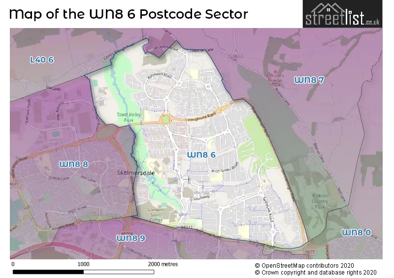
The WN8 6 Postcode shares a border with WN8 8 (SKELMERSDALE, Lathom, Chapel House), WN8 9 (SKELMERSDALE, Crawford Village, Upholland), WN8 0 (Upholland, SKELMERSDALE, Roby Mill), WN8 7 (Parbold, Newburgh, Dalton) and L40 6 (Westhead, Lathom).
The sector is within the post town of SKELMERSDALE.
WN8 6 is a postcode sector within the WN8 postcode district which is within the WN Wigan postcode area.
The Royal Mail delivery office for the WN8 6 postal sector is the Skelmersdale Delivery Office.
The area of the WN8 6 postcode sector is 2.09 square miles which is 5.43 square kilometres or 1,340.55 square acres.

Map of the WN8 6 Postcode Sector
Explore the WN8 6 postcode sector by using our free interactive map.
| W | N | 8 | - | 6 | X | X |
| W | N | 8 | Space | 6 | Letter | Letter |
Official List of Streets
SKELMERSDALE (152 Streets)
Unofficial Streets or Alternative Spellings
Dalton
BEACON LANEStanley Industrial Estate
STANLEY WAYLathom
VALE LANEWeather Forecast for WN8 6
Press Button to Show Forecast for Skelmersdale
| Time Period | Icon | Description | Temperature | Rain Probability | Wind |
|---|---|---|---|---|---|
| 18:00 to 21:00 | Cloudy | 10.0°C (feels like 8.0°C) | 5.00% | NNW 9 mph | |
| 21:00 to 00:00 | Cloudy | 9.0°C (feels like 7.0°C) | 4.00% | NNW 7 mph |
Press Button to Show Forecast for Skelmersdale
| Time Period | Icon | Description | Temperature | Rain Probability | Wind |
|---|---|---|---|---|---|
| 00:00 to 03:00 | Cloudy | 8.0°C (feels like 7.0°C) | 5.00% | NE 4 mph | |
| 03:00 to 06:00 | Partly cloudy (night) | 6.0°C (feels like 5.0°C) | 1.00% | ENE 4 mph | |
| 06:00 to 09:00 | Sunny day | 5.0°C (feels like 3.0°C) | 0.00% | NE 4 mph | |
| 09:00 to 12:00 | Sunny day | 7.0°C (feels like 5.0°C) | 0.00% | NNE 7 mph | |
| 12:00 to 15:00 | Partly cloudy (day) | 10.0°C (feels like 8.0°C) | 1.00% | N 7 mph | |
| 15:00 to 18:00 | Partly cloudy (day) | 10.0°C (feels like 8.0°C) | 1.00% | NW 11 mph | |
| 18:00 to 21:00 | Sunny day | 9.0°C (feels like 6.0°C) | 1.00% | NW 9 mph | |
| 21:00 to 00:00 | Partly cloudy (night) | 7.0°C (feels like 5.0°C) | 1.00% | WNW 4 mph |
Press Button to Show Forecast for Skelmersdale
| Time Period | Icon | Description | Temperature | Rain Probability | Wind |
|---|---|---|---|---|---|
| 00:00 to 03:00 | Cloudy | 6.0°C (feels like 5.0°C) | 3.00% | WNW 7 mph | |
| 03:00 to 06:00 | Cloudy | 6.0°C (feels like 4.0°C) | 4.00% | WNW 7 mph | |
| 06:00 to 09:00 | Cloudy | 7.0°C (feels like 4.0°C) | 6.00% | WNW 7 mph | |
| 09:00 to 12:00 | Partly cloudy (day) | 8.0°C (feels like 6.0°C) | 5.00% | NW 11 mph | |
| 12:00 to 15:00 | Cloudy | 10.0°C (feels like 7.0°C) | 8.00% | NW 11 mph | |
| 15:00 to 18:00 | Cloudy | 10.0°C (feels like 8.0°C) | 7.00% | NW 9 mph | |
| 18:00 to 21:00 | Cloudy | 9.0°C (feels like 7.0°C) | 7.00% | NNW 7 mph | |
| 21:00 to 00:00 | Partly cloudy (night) | 7.0°C (feels like 6.0°C) | 4.00% | NNE 4 mph |
Press Button to Show Forecast for Skelmersdale
| Time Period | Icon | Description | Temperature | Rain Probability | Wind |
|---|---|---|---|---|---|
| 00:00 to 03:00 | Cloudy | 6.0°C (feels like 4.0°C) | 7.00% | ESE 7 mph | |
| 03:00 to 06:00 | Cloudy | 5.0°C (feels like 3.0°C) | 11.00% | ENE 7 mph | |
| 06:00 to 09:00 | Cloudy | 5.0°C (feels like 3.0°C) | 8.00% | ENE 7 mph | |
| 09:00 to 12:00 | Cloudy | 7.0°C (feels like 5.0°C) | 9.00% | ESE 7 mph | |
| 12:00 to 15:00 | Overcast | 9.0°C (feels like 7.0°C) | 14.00% | E 7 mph | |
| 15:00 to 18:00 | Cloudy | 10.0°C (feels like 9.0°C) | 10.00% | ESE 7 mph | |
| 18:00 to 21:00 | Cloudy | 10.0°C (feels like 8.0°C) | 12.00% | ENE 7 mph | |
| 21:00 to 00:00 | Cloudy | 8.0°C (feels like 6.0°C) | 14.00% | E 9 mph |
Press Button to Show Forecast for Skelmersdale
| Time Period | Icon | Description | Temperature | Rain Probability | Wind |
|---|---|---|---|---|---|
| 00:00 to 03:00 | Cloudy | 7.0°C (feels like 4.0°C) | 15.00% | E 9 mph | |
| 03:00 to 06:00 | Cloudy | 6.0°C (feels like 4.0°C) | 16.00% | E 7 mph | |
| 06:00 to 09:00 | Light rain | 6.0°C (feels like 3.0°C) | 45.00% | E 7 mph | |
| 09:00 to 12:00 | Cloudy | 8.0°C (feels like 6.0°C) | 16.00% | E 9 mph | |
| 12:00 to 15:00 | Overcast | 10.0°C (feels like 8.0°C) | 17.00% | E 9 mph | |
| 15:00 to 18:00 | Cloudy | 11.0°C (feels like 9.0°C) | 17.00% | ENE 9 mph | |
| 18:00 to 21:00 | Cloudy | 10.0°C (feels like 8.0°C) | 14.00% | NE 9 mph | |
| 21:00 to 00:00 | Cloudy | 9.0°C (feels like 7.0°C) | 13.00% | NE 9 mph |
Schools and Places of Education Within the WN8 6 Postcode Sector
Cobbs Brow School
Community school
Manfield, Skelmersdale, Lancashire, WN8 6SU
Head: Mr Ian Eaton
Ofsted Rating: Outstanding
Inspection: 2014-07-10 (3575 days ago)
Website: Visit Cobbs Brow School Website
Phone: 01695720632
Number of Pupils: 323
Delph Side Community Primary School
Community school
Eskdale, Skelmersdale, Lancashire, WN8 6ED
Head: Mrs Elizabeth Ormerod
Ofsted Rating: Good
Inspection: 2020-01-09 (1566 days ago)
Website: Visit Delph Side Community Primary School Website
Phone: 01695721881
Number of Pupils: 258
Elm Tree Community Primary School
Community special school
Elmers Wood Road, Skelmersdale, Lancashire, WN8 6SA
Head: Mr David Lamb
Ofsted Rating: Outstanding
Inspection: 2023-11-15 (160 days ago)
Website: Visit Elm Tree Community Primary School Website
Phone: 0169550924
Number of Pupils: 145
Hillside Community Primary School
Community school
Egerton, Skelmersdale, Lancashire, WN8 6DE
Head: Angela Aspinwall-Livesey
Ofsted Rating: Outstanding
Inspection: 2023-02-23 (425 days ago)
Website: Visit Hillside Community Primary School Website
Phone: 01695724860
Number of Pupils: 199
Lathom High School : A Technology College
Foundation school
Glenburn Road, Skelmersdale, Lancashire, WN8 6JN
Head: Mrs Jane Galbraith
Ofsted Rating: Good
Inspection: 2022-06-15 (678 days ago)
Website: Visit Lathom High School : A Technology College Website
Phone: 01695725653
Number of Pupils: 644
Our Lady Queen of Peace Catholic Engineering College
Voluntary aided school
Glenburn Road, Skelmersdale, Lancashire, WN8 6JW
Head: Mrs Mary Henshaw
Ofsted Rating: Special Measures
Inspection: 2023-06-28 (300 days ago)
Website: Visit Our Lady Queen of Peace Catholic Engineering College Website
Phone: 01695725635
Number of Pupils: 915
St James' Catholic Primary School, Skelmersdale
Voluntary aided school
Ashurst Road, Skelmersdale, Lancashire, WN8 6TN
Head: Mrs Angela Blacoe
Ofsted Rating: Good
Inspection: 2023-02-23 (425 days ago)
Website: Visit St James' Catholic Primary School, Skelmersdale Website
Phone: 01695728989
Number of Pupils: 221
St John's Catholic Primary School, Skelmersdale
Voluntary aided school
Flamstead, Skelmersdale, Lancashire, WN8 6PF
Head: Mrs Angela Aspinwall-Livesey
Ofsted Rating: Good
Inspection: 2022-07-07 (656 days ago)
Website: Visit St John's Catholic Primary School, Skelmersdale Website
Phone: 01695721323
Number of Pupils: 201
Woodlands Community Primary School
Community school
Heathgate, Skelmersdale, Lancashire, WN8 6QH
Head: Mrs Keeley Taberner
Ofsted Rating: Good
Inspection: 2023-03-14 (406 days ago)
Website: Visit Woodlands Community Primary School Website
Phone: 01695720018
Number of Pupils: 385
House Prices in the WN8 6 Postcode Sector
| Type of Property | 2018 Average | 2018 Sales | 2017 Average | 2017 Sales | 2016 Average | 2016 Sales | 2015 Average | 2015 Sales |
|---|---|---|---|---|---|---|---|---|
| Detached | £200,135 | 59 | £191,269 | 47 | £192,375 | 55 | £176,246 | 39 |
| Semi-Detached | £130,205 | 83 | £127,943 | 54 | £112,922 | 42 | £112,518 | 41 |
| Terraced | £83,301 | 63 | £77,805 | 69 | £72,334 | 56 | £67,433 | 63 |
| Flats | £64,125 | 4 | £77,583 | 6 | £58,750 | 8 | £67,431 | 8 |
Important Postcodes WN8 6 in the Postcode Sector
WN8 6AB is the postcode for Hillside Cp School, Egerton, and Hillside Community Primary School, Egerton, Tanhouse
WN8 6AU is the postcode for Eavesdale Family And Children Wellbeing Service, Eavesdale, Tanhouse
WN8 6BA is the postcode for Beacon School, Tanhouse Road, and First Steps Childrens Centre, Tanhouse Road
WN8 6DS is the postcode for Hillside Health Centre, Tanhouse Road
WN8 6DX is the postcode for SPORTS HALL, West Lancashire College, Skelmersdale Campus, West Lancashire College Skelmersdale Campus, College Way, MAIN BUILDING, West Lancashire College, Skelmersdale Campus, and Construction Egineering Logistics, West Lancashire College
WN8 6ED is the postcode for Delphside Primary School, Eskdale
WN8 6JA is the postcode for Calder Building, Skelmersdale & Ormskirk College, Ribble Building, Skelmersdale & Ormskirk College, Single Storey Building, Skelmersdale & Ormskirk College, and Pendle Building, Skelmersdale & Ormskirk College
WN8 6JB is the postcode for BLOCK 1, Glenburn High School & Sports College, Yewdale, BLOCK 4, Glenburn High School & Sports College, Yewdale, BLOCK 3, Glenburn High School & Sports College, Yewdale, Glenburn High School & Sports College, Yewdale, and MAIN BUILDING, Glenburn High School & Sports College, Yewdale
WN8 6JN is the postcode for Lathom High School, Glenburn Road
WN8 6JW is the postcode for SPORTS HALL, Our Lady Queen of Peace Catholic Engineering College, Glenburn Road, and Our Lady Queen of Peace Catholic Engineering College, Glenburn Road
WN8 6LJ is the postcode for Central Lancashire NHS Walk in Centre, 116-118 The Concourse, and Skelmersdale NHS Walk in Centre, The Concourse
WN8 6LT is the postcode for Nye Bevan Swimming Pool, Southway
WN8 6NH is the postcode for Lancashire Constabulary, Police Station, Southway
WN8 6NL is the postcode for Lancashire County Council, Library, Southway, and Southway Neighbourhood Centre, Southway
WN8 6NS is the postcode for Jobcentre Plus, Whelmar House
WN8 6PF is the postcode for St. Johns RC Primary School, Flamstead, and St Johns Catholic Primary School, Flamstead, Birch Green
WN8 6QH is the postcode for Woodlands Community Primary School, Heathgate, Birch Green, and Woodland C P School, Heathgate
WN8 6QS is the postcode for Ashurst Health Centre, Lulworth
WN8 6RG is the postcode for Children & Parenting Support Service Centre, Fairlie
WN8 6SA is the postcode for Elm Tree Community Primary School, Elmers Wood Road
WN8 6SU is the postcode for Cobbs Brow Cp School, Manfield, and Cobbs Brow Primary School, Manfield
WN8 6TN is the postcode for St. James RC Primary School, Ashurst Road
| The WN8 6 Sector is within these Local Authorities |
|
|---|---|
| The WN8 6 Sector is within these Counties |
|
| The WN8 6 Sector is within these Water Company Areas |
|