The WN8 7 postcode sector is within the county of Lancashire.
Did you know? According to the 2021 Census, the WN8 7 postcode sector is home to a bustling 4,294 residents!
Given that each sector allows for 400 unique postcode combinations. Letters C, I, K, M, O and V are not allowed in the last two letters of a postcode. With 122 postcodes already in use, this leaves 278 units available.
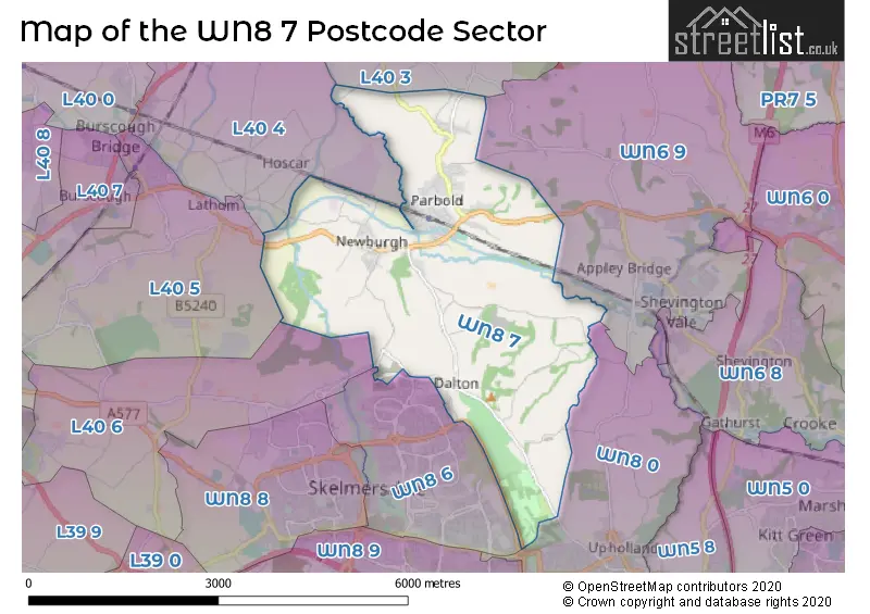
The largest settlement in the WN8 7 postal code is Parbold followed by Newburgh, and Dalton.
The WN8 7 Postcode shares a border with L40 3 (Mawdesley, Bispham), L40 4 (Burscough, Lathom), WN6 9 (Appley Bridge, Wrightington), WN8 0 (Upholland, SKELMERSDALE, Roby Mill), WN8 6 (SKELMERSDALE), L40 5 (Burscough, Lathom) and L40 6 (Westhead, Lathom).
The sector is within the post town of WIGAN.
WN8 7 is a postcode sector within the WN8 postcode district which is within the WN Wigan postcode area.
The Royal Mail delivery office for the WN8 7 postal sector is the Skelmersdale Delivery Office.
The area of the WN8 7 postcode sector is 7.40 square miles which is 19.18 square kilometres or 4,738.95 square acres.
Waterways within the WN8 7 postcode sector include the River Douglas, Leeds and Liverpool Canal.

Map of the WN8 7 Postcode Sector
Explore the WN8 7 postcode sector by using our free interactive map.
| W | N | 8 | - | 7 | X | X |
| W | N | 8 | Space | 7 | Letter | Letter |
Official List of Streets
Newburgh (21 Streets)
Parbold (51 Streets)
Unofficial Streets or Alternative Spellings
Roby Mill
FARLEY LANE BRIDGE 39 COBBS CLOUGH ROAD COCK LANE EAST DENE FAIRHURSTS DRIVE HARTS LANE HOLLOWFORD LANE/BACK LANE LONG HEYS OR BACK LANE MAINS LANE MALTKIN LANE MILL FIELD MILL LEAT SPARROW HILL STANNANOUGHT ROAD STONEHALL LANE STONY LANE THE HAW THORNS THE VILLAS TOWING PATH ULVERSTON DRIVE WEST DENE WHALLEYS ROADSKELMERSDALE
KESTREL PARK OLDBURY WAY OXHILL ROAD VINES CROSS WAYBispham
CHORLEY ROAD HALL LANE MALTKILN LANELathom
DEANS LANE WANES BLADES ROADWeather Forecast for WN8 7
Press Button to Show Forecast for Skelmersdale
| Time Period | Icon | Description | Temperature | Rain Probability | Wind |
|---|---|---|---|---|---|
| 00:00 to 03:00 | Cloudy | 8.0°C (feels like 7.0°C) | 5.00% | NE 4 mph | |
| 03:00 to 06:00 | Partly cloudy (night) | 6.0°C (feels like 5.0°C) | 1.00% | ENE 4 mph | |
| 06:00 to 09:00 | Sunny day | 5.0°C (feels like 3.0°C) | 0.00% | NE 4 mph | |
| 09:00 to 12:00 | Sunny day | 7.0°C (feels like 5.0°C) | 0.00% | NNE 7 mph | |
| 12:00 to 15:00 | Partly cloudy (day) | 10.0°C (feels like 8.0°C) | 1.00% | N 7 mph | |
| 15:00 to 18:00 | Partly cloudy (day) | 10.0°C (feels like 8.0°C) | 1.00% | NW 11 mph | |
| 18:00 to 21:00 | Sunny day | 9.0°C (feels like 6.0°C) | 1.00% | NW 9 mph | |
| 21:00 to 00:00 | Partly cloudy (night) | 7.0°C (feels like 5.0°C) | 1.00% | WNW 4 mph |
Press Button to Show Forecast for Skelmersdale
| Time Period | Icon | Description | Temperature | Rain Probability | Wind |
|---|---|---|---|---|---|
| 00:00 to 03:00 | Cloudy | 6.0°C (feels like 5.0°C) | 3.00% | WNW 7 mph | |
| 03:00 to 06:00 | Cloudy | 6.0°C (feels like 4.0°C) | 4.00% | WNW 7 mph | |
| 06:00 to 09:00 | Cloudy | 7.0°C (feels like 4.0°C) | 6.00% | WNW 7 mph | |
| 09:00 to 12:00 | Partly cloudy (day) | 8.0°C (feels like 6.0°C) | 5.00% | NW 11 mph | |
| 12:00 to 15:00 | Cloudy | 10.0°C (feels like 7.0°C) | 8.00% | NW 11 mph | |
| 15:00 to 18:00 | Cloudy | 10.0°C (feels like 8.0°C) | 7.00% | NW 9 mph | |
| 18:00 to 21:00 | Cloudy | 9.0°C (feels like 7.0°C) | 7.00% | NNW 7 mph | |
| 21:00 to 00:00 | Partly cloudy (night) | 7.0°C (feels like 6.0°C) | 4.00% | NNE 4 mph |
Press Button to Show Forecast for Skelmersdale
| Time Period | Icon | Description | Temperature | Rain Probability | Wind |
|---|---|---|---|---|---|
| 00:00 to 03:00 | Cloudy | 6.0°C (feels like 4.0°C) | 7.00% | ESE 7 mph | |
| 03:00 to 06:00 | Cloudy | 5.0°C (feels like 3.0°C) | 11.00% | ENE 7 mph | |
| 06:00 to 09:00 | Cloudy | 5.0°C (feels like 3.0°C) | 8.00% | ENE 7 mph | |
| 09:00 to 12:00 | Cloudy | 7.0°C (feels like 5.0°C) | 9.00% | ESE 7 mph | |
| 12:00 to 15:00 | Overcast | 9.0°C (feels like 7.0°C) | 14.00% | E 7 mph | |
| 15:00 to 18:00 | Cloudy | 10.0°C (feels like 9.0°C) | 10.00% | ESE 7 mph | |
| 18:00 to 21:00 | Cloudy | 10.0°C (feels like 8.0°C) | 12.00% | ENE 7 mph | |
| 21:00 to 00:00 | Cloudy | 8.0°C (feels like 6.0°C) | 14.00% | E 9 mph |
Press Button to Show Forecast for Skelmersdale
| Time Period | Icon | Description | Temperature | Rain Probability | Wind |
|---|---|---|---|---|---|
| 00:00 to 03:00 | Cloudy | 7.0°C (feels like 4.0°C) | 15.00% | E 9 mph | |
| 03:00 to 06:00 | Cloudy | 6.0°C (feels like 4.0°C) | 16.00% | E 7 mph | |
| 06:00 to 09:00 | Light rain | 6.0°C (feels like 3.0°C) | 45.00% | E 7 mph | |
| 09:00 to 12:00 | Cloudy | 8.0°C (feels like 6.0°C) | 16.00% | E 9 mph | |
| 12:00 to 15:00 | Overcast | 10.0°C (feels like 8.0°C) | 17.00% | E 9 mph | |
| 15:00 to 18:00 | Cloudy | 11.0°C (feels like 9.0°C) | 17.00% | ENE 9 mph | |
| 18:00 to 21:00 | Cloudy | 10.0°C (feels like 8.0°C) | 14.00% | NE 9 mph | |
| 21:00 to 00:00 | Cloudy | 9.0°C (feels like 7.0°C) | 13.00% | NE 9 mph |
Schools and Places of Education Within the WN8 7 Postcode Sector
Dalton St Michael's Church of England Primary School
Voluntary aided school
Higher Lane, Wigan, Lancashire, WN8 7RP
Head: Ms A Robinson
Ofsted Rating: Good
Inspection: 2023-03-09 (412 days ago)
Website: Visit Dalton St Michael's Church of England Primary School Website
Phone: 01257462082
Number of Pupils: 59
Newburgh Church of England Primary School
Voluntary aided school
Back Lane, Wigan, Lancashire, WN8 7XB
Head: Mrs Rebecca Fowler
Ofsted Rating: Outstanding
Inspection: 2011-05-25 (4718 days ago)
Website: Visit Newburgh Church of England Primary School Website
Phone: 01257462916
Number of Pupils: 120
Our Lady and All Saints Roman Catholic Primary School, Parbold
Voluntary aided school
Brandreth Drive, Wigan, Lancashire, WN8 7HD
Head: Mr Shaun Kearon
Ofsted Rating: Outstanding
Inspection: 2013-01-10 (4122 days ago)
Website: Visit Our Lady and All Saints Roman Catholic Primary School, Parbold Website
Phone: 01257462466
Number of Pupils: 109
Parbold Douglas Church of England Academy
Academy converter
Lancaster Lane, Nr Wigan, Lancashire, WN8 7HS
Head: Mr John Coxhead
Ofsted Rating: Outstanding
Inspection: 2023-11-22 (154 days ago)
Website: Visit Parbold Douglas Church of England Academy Website
Phone: 01257462007
Number of Pupils: 182
House Prices in the WN8 7 Postcode Sector
| Type of Property | 2018 Average | 2018 Sales | 2017 Average | 2017 Sales | 2016 Average | 2016 Sales | 2015 Average | 2015 Sales |
|---|---|---|---|---|---|---|---|---|
| Detached | £398,619 | 37 | £408,138 | 38 | £436,223 | 26 | £424,900 | 28 |
| Semi-Detached | £275,568 | 34 | £214,598 | 30 | £217,540 | 27 | £192,908 | 24 |
| Terraced | £189,140 | 10 | £181,875 | 8 | £131,643 | 7 | £174,762 | 12 |
| Flats | £92,713 | 2 | £137,667 | 3 | £109,500 | 2 | £80,000 | 2 |
Important Postcodes WN8 7 in the Postcode Sector
WN8 7DN is the postcode for Doctors Surgery, 4 The Green
WN8 7HD is the postcode for Our Lady & All Saints RC School, Brandreth Drive
WN8 7HS is the postcode for Parbold Douglas C Of E Academy, Lancaster Lane, and Parbold Douglas C of E Primary School, Lancaster Lane
WN8 7RU is the postcode for Beacon Park Golf & Country Club, Beacon Lane
WN8 7XB is the postcode for Newburgh C of E School, Back Lane
| The WN8 7 Sector is within these Local Authorities |
|
|---|---|
| The WN8 7 Sector is within these Counties |
|
| The WN8 7 Sector is within these Water Company Areas |
|