The WS1 2 postcode sector is within the county of West Midlands.
Did you know? According to the 2021 Census, the WS1 2 postcode sector is home to a bustling 7,738 residents!
Given that each sector allows for 400 unique postcode combinations. Letters C, I, K, M, O and V are not allowed in the last two letters of a postcode. With 166 postcodes already in use, this leaves 234 units available.
The WS1 2 postal code covers the settlement of WALSALL.
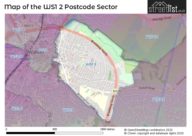
The WS1 2 Postcode shares a border with WS1 1 (WALSALL), WS1 3 (WALSALL), WS4 2 (WALSALL) and WS5 3 (WALSALL).
The sector is within the post town of WALSALL.
WS1 2 is a postcode sector within the WS1 postcode district which is within the WS Walsall postcode area.
The Royal Mail delivery office for the WS1 2 postal sector is the Walsall Delivery Office.
The area of the WS1 2 postcode sector is 0.66 square miles which is 1.71 square kilometres or 422.10 square acres.

Map of the WS1 2 Postcode Sector
Explore the WS1 2 postcode sector by using our free interactive map.
| W | S | 1 | - | 2 | X | X |
| W | S | 1 | Space | 2 | Letter | Letter |
Official List of Streets
WALSALL (69 Streets)
Unofficial Streets or Alternative Spellings
Weather Forecast for WS1 2
Press Button to Show Forecast for Walsall
| Time Period | Icon | Description | Temperature | Rain Probability | Wind |
|---|---|---|---|---|---|
| 21:00 to 00:00 | Cloudy | 6.0°C (feels like 5.0°C) | 5.00% | ENE 4 mph |
Press Button to Show Forecast for Walsall
| Time Period | Icon | Description | Temperature | Rain Probability | Wind |
|---|---|---|---|---|---|
| 00:00 to 03:00 | Cloudy | 5.0°C (feels like 3.0°C) | 6.00% | ENE 4 mph | |
| 03:00 to 06:00 | Cloudy | 3.0°C (feels like 1.0°C) | 4.00% | ENE 4 mph | |
| 06:00 to 09:00 | Partly cloudy (day) | 3.0°C (feels like 1.0°C) | 1.00% | ENE 4 mph | |
| 09:00 to 12:00 | Cloudy | 6.0°C (feels like 4.0°C) | 6.00% | ENE 7 mph | |
| 12:00 to 15:00 | Cloudy | 9.0°C (feels like 7.0°C) | 9.00% | ENE 4 mph | |
| 15:00 to 18:00 | Overcast | 9.0°C (feels like 8.0°C) | 12.00% | ENE 4 mph | |
| 18:00 to 21:00 | Cloudy | 9.0°C (feels like 7.0°C) | 9.00% | ENE 4 mph | |
| 21:00 to 00:00 | Partly cloudy (night) | 6.0°C (feels like 3.0°C) | 8.00% | E 7 mph |
Press Button to Show Forecast for Walsall
| Time Period | Icon | Description | Temperature | Rain Probability | Wind |
|---|---|---|---|---|---|
| 00:00 to 03:00 | Partly cloudy (night) | 4.0°C (feels like 1.0°C) | 8.00% | ENE 7 mph | |
| 03:00 to 06:00 | Cloudy | 3.0°C (feels like 0.0°C) | 11.00% | ENE 7 mph | |
| 06:00 to 09:00 | Cloudy | 3.0°C (feels like 1.0°C) | 11.00% | ENE 7 mph | |
| 09:00 to 12:00 | Cloudy | 7.0°C (feels like 4.0°C) | 15.00% | ENE 9 mph | |
| 12:00 to 15:00 | Overcast | 9.0°C (feels like 7.0°C) | 21.00% | ENE 9 mph | |
| 15:00 to 18:00 | Overcast | 10.0°C (feels like 8.0°C) | 23.00% | ENE 9 mph | |
| 18:00 to 21:00 | Cloudy | 9.0°C (feels like 7.0°C) | 18.00% | ENE 9 mph | |
| 21:00 to 00:00 | Cloudy | 7.0°C (feels like 4.0°C) | 20.00% | NE 11 mph |
Press Button to Show Forecast for Walsall
| Time Period | Icon | Description | Temperature | Rain Probability | Wind |
|---|---|---|---|---|---|
| 00:00 to 03:00 | Overcast | 6.0°C (feels like 3.0°C) | 21.00% | NE 11 mph | |
| 03:00 to 06:00 | Light rain | 6.0°C (feels like 3.0°C) | 51.00% | NE 11 mph | |
| 06:00 to 09:00 | Heavy rain | 6.0°C (feels like 3.0°C) | 77.00% | NNE 11 mph | |
| 09:00 to 12:00 | Heavy rain | 7.0°C (feels like 4.0°C) | 77.00% | N 11 mph | |
| 12:00 to 15:00 | Light rain | 9.0°C (feels like 6.0°C) | 55.00% | N 11 mph | |
| 15:00 to 18:00 | Light rain | 9.0°C (feels like 7.0°C) | 53.00% | NNE 11 mph | |
| 18:00 to 21:00 | Light rain shower (day) | 9.0°C (feels like 7.0°C) | 40.00% | N 9 mph | |
| 21:00 to 00:00 | Partly cloudy (night) | 7.0°C (feels like 5.0°C) | 11.00% | N 7 mph |
Schools and Places of Education Within the WS1 2 Postcode Sector
Blue Coat Church of England Academy
Academy sponsor led
Birmingham Street, Walsall, West Midlands, WS1 2ND
Head: Mr David Smith
Ofsted Rating: Good
Inspection: 2023-01-25 (456 days ago)
Website: Visit Blue Coat Church of England Academy Website
Phone: 01922720558
Number of Pupils: 897
Blue Coat Church of England Aided Junior School
Voluntary aided school
Springhill Road, Walsall, West Midlands, WS1 2LP
Head: Mr Anthony Orlik
Ofsted Rating: Good
Inspection: 2019-04-03 (1849 days ago)
Website: Visit Blue Coat Church of England Aided Junior School Website
Phone: 01922720921
Number of Pupils: 359
Chuckery Primary School
Community school
Lincoln Road, Walsall, West Midlands, WS1 2DZ
Head: Mr James Pearce
Ofsted Rating: Good
Inspection: 2023-09-14 (224 days ago)
Website: Visit Chuckery Primary School Website
Phone: 01922449104
Number of Pupils: 459
Queen Mary's Grammar School
Academy converter
Sutton Road, Walsall, West Midlands, WS1 2PG
Head: Mr Richard Langton
Ofsted Rating: Outstanding
Inspection: 2023-03-29 (393 days ago)
Website: Visit Queen Mary's Grammar School Website
Phone: 01922720696
Number of Pupils: 1312
House Prices in the WS1 2 Postcode Sector
| Type of Property | 2018 Average | 2018 Sales | 2017 Average | 2017 Sales | 2016 Average | 2016 Sales | 2015 Average | 2015 Sales |
|---|---|---|---|---|---|---|---|---|
| Detached | £315,423 | 12 | £340,573 | 13 | £281,881 | 13 | £282,385 | 26 |
| Semi-Detached | £207,784 | 28 | £214,291 | 17 | £211,962 | 26 | £196,137 | 21 |
| Terraced | £111,059 | 31 | £127,940 | 29 | £135,656 | 32 | £106,290 | 31 |
| Flats | £110,954 | 38 | £109,699 | 32 | £129,825 | 69 | £82,525 | 24 |
Important Postcodes WS1 2 in the Postcode Sector
WS1 2DZ is the postcode for Chuckery Primary School, Lincoln Road, CHUCKERY PRIMARY SCHOOL, LINCOLN ROAD, WALSALL, and DINING BLOCK, Chuckery Primary School, Lincoln Road
WS1 2JP is the postcode for ELDON COURT, UNIT 3, ELDONWOOD, Eldon Court, 42-43 Eldon Street, and UNIT 4, ELDONWOOD, ELDON STREET
WS1 2LP is the postcode for Blue Coat C of E (Aided) Junior School, Springhill Road
WS1 2LX is the postcode for The Limes Medical Centre, 5 Birmingham Road
WS1 2ND is the postcode for MAIN BUILDING, Blue Coat CofE Academy, Birmingham Street, SCIENCE BUILDING, Blue Coat CofE Academy, Birmingham Street, SPORTS HALL, Blue Coat CofE Academy, Birmingham Street, and GROVE BUILDING, Blue Coat CofE Academy, Birmingham Street
WS1 2NL is the postcode for Sycamore House Medical Centre, 111 Birmingham Road
WS1 2PG is the postcode for MAIN BUILDING, Queen Marys Grammar School, Sutton Road, 6TH FORM BUILDING, Queen Marys Grammar School, Sutton Road, and SPORTS BLOCK, Queen Marys Grammar School, Sutton Road
WS1 2QA is the postcode for Walsall Council, Broadway North Resource Centre
| The WS1 2 Sector is within these Local Authorities |
|
|---|---|
| The WS1 2 Sector is within these Counties |
|
| The WS1 2 Sector is within these Water Company Areas |
|