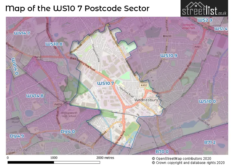
The WS10 7 postcode sector is within the county of West Midlands.
Did you know? According to the 2021 Census, the WS10 7 postcode sector is home to a bustling 7,630 residents!
Given that each sector allows for 400 unique postcode combinations. Letters C, I, K, M, O and V are not allowed in the last two letters of a postcode. With 179 postcodes already in use, this leaves 221 units available.
The largest settlements in the WS10 7 postal code are WEDNESBURY and Darlaston.
The WS10 7 Postcode shares a border with WS10 0 (WEDNESBURY), WS10 8 (WEDNESBURY, Darlaston, Moxley), WS10 9 (WEDNESBURY) and DY4 0 (TIPTON, Ocker Hill).
The sector is within the post town of WEDNESBURY.
WS10 7 is a postcode sector within the WS10 postcode district which is within the WS Walsall postcode area.
The Royal Mail delivery office for the WS10 7 postal sector is the Wednesbury Delivery Office.
The area of the WS10 7 postcode sector is 1.17 square miles which is 3.02 square kilometres or 747.28 square acres.
Waterways within the WS10 7 postcode sector include the Bradley Locks Branch, Gospel Oak Branch, Walsall Canal.


Map of the WS10 7 Postcode Sector
Explore the WS10 7 postcode sector by using our free interactive map.
| W | S | 1 | 0 | - | 7 | X | X |
| W | S | 1 | 0 | Space | 7 | Letter | Letter |
Official List of Streets
WEDNESBURY (95 Streets)
Darlaston (3 Streets)
Moxley (1 Streets)
Unofficial Streets or Alternative Spellings
WEDNESBURY
ADDISON TERRACE BLACK HORSE CLOSE BRIDGE STREET BRIGHT STREET CHURCH HILL LITTLE HILL NOWELL STREET OLD PARK ROAD PERRY STREET PINFOLD STREET RIDDING LANE SCHOOL STREET SPRING HEAD THREADBOLT WAY WALSALL ROAD WALSALL STREET WHITLEY STREET WOLVERHAMPTON STREET IRONMILL WAY JAVELIN PARK KINGS HILL FIELD KINGS HILL PARK LOXDALE STREET MOORCROFT JUNCTION BRIDGE PATENT SHAFT ROUNDABOUT PINFOLD COURT PLATT STREET SAINT JOHNS ROAD SHAMBLES ST. JOHNS COURT STEEL ROUNDABOUT WOODS BANK TERRACETIPTON
FARMER WAY NEWMAN ROAD SEYMOUR ROADTIPTON,
BLACK COUNTRY NEW ROAD LEABROOK ROADMoxley
CHURCH STREETBILSTON,
BULL LANEWeather Forecast for WS10 7
Press Button to Show Forecast for Wednesbury
| Time Period | Icon | Description | Temperature | Rain Probability | Wind |
|---|---|---|---|---|---|
| 15:00 to 18:00 | Light rain | 8.0°C (feels like 6.0°C) | 42.00% | NNE 7 mph | |
| 18:00 to 21:00 | Cloudy | 7.0°C (feels like 5.0°C) | 8.00% | NE 7 mph | |
| 21:00 to 00:00 | Cloudy | 6.0°C (feels like 5.0°C) | 5.00% | ENE 4 mph |
Press Button to Show Forecast for Wednesbury
| Time Period | Icon | Description | Temperature | Rain Probability | Wind |
|---|---|---|---|---|---|
| 00:00 to 03:00 | Cloudy | 5.0°C (feels like 3.0°C) | 7.00% | E 4 mph | |
| 03:00 to 06:00 | Cloudy | 3.0°C (feels like 1.0°C) | 7.00% | ENE 4 mph | |
| 06:00 to 09:00 | Partly cloudy (day) | 3.0°C (feels like 1.0°C) | 2.00% | ENE 4 mph | |
| 09:00 to 12:00 | Cloudy | 6.0°C (feels like 4.0°C) | 6.00% | ENE 7 mph | |
| 12:00 to 15:00 | Cloudy | 9.0°C (feels like 7.0°C) | 9.00% | ENE 4 mph | |
| 15:00 to 18:00 | Overcast | 9.0°C (feels like 8.0°C) | 12.00% | ENE 4 mph | |
| 18:00 to 21:00 | Cloudy | 9.0°C (feels like 7.0°C) | 9.00% | ENE 4 mph | |
| 21:00 to 00:00 | Partly cloudy (night) | 6.0°C (feels like 3.0°C) | 8.00% | E 7 mph |
Press Button to Show Forecast for Wednesbury
| Time Period | Icon | Description | Temperature | Rain Probability | Wind |
|---|---|---|---|---|---|
| 00:00 to 03:00 | Partly cloudy (night) | 4.0°C (feels like 1.0°C) | 8.00% | ENE 7 mph | |
| 03:00 to 06:00 | Cloudy | 3.0°C (feels like 0.0°C) | 11.00% | ENE 7 mph | |
| 06:00 to 09:00 | Cloudy | 3.0°C (feels like 1.0°C) | 11.00% | ENE 7 mph | |
| 09:00 to 12:00 | Cloudy | 7.0°C (feels like 4.0°C) | 15.00% | ENE 9 mph | |
| 12:00 to 15:00 | Overcast | 9.0°C (feels like 7.0°C) | 21.00% | ENE 9 mph | |
| 15:00 to 18:00 | Overcast | 10.0°C (feels like 8.0°C) | 23.00% | ENE 9 mph | |
| 18:00 to 21:00 | Cloudy | 9.0°C (feels like 7.0°C) | 18.00% | ENE 9 mph | |
| 21:00 to 00:00 | Cloudy | 7.0°C (feels like 4.0°C) | 20.00% | NE 11 mph |
Press Button to Show Forecast for Wednesbury
| Time Period | Icon | Description | Temperature | Rain Probability | Wind |
|---|---|---|---|---|---|
| 00:00 to 03:00 | Overcast | 6.0°C (feels like 3.0°C) | 21.00% | NE 11 mph | |
| 03:00 to 06:00 | Light rain | 6.0°C (feels like 3.0°C) | 53.00% | NE 11 mph | |
| 06:00 to 09:00 | Heavy rain | 6.0°C (feels like 3.0°C) | 75.00% | NNE 11 mph | |
| 09:00 to 12:00 | Heavy rain | 7.0°C (feels like 4.0°C) | 77.00% | N 11 mph | |
| 12:00 to 15:00 | Light rain | 9.0°C (feels like 6.0°C) | 55.00% | N 11 mph | |
| 15:00 to 18:00 | Light rain | 9.0°C (feels like 6.0°C) | 53.00% | NNE 11 mph | |
| 18:00 to 21:00 | Light rain shower (day) | 9.0°C (feels like 7.0°C) | 41.00% | N 9 mph | |
| 21:00 to 00:00 | Partly cloudy (night) | 7.0°C (feels like 5.0°C) | 11.00% | N 7 mph |
Schools and Places of Education Within the WS10 7 Postcode Sector
Holyhead Primary Academy
Academy sponsor led
Holyhead Road, Wednesbury, West Midlands, WS10 7PZ
Head: Mrs Natalie Shipley
Ofsted Rating: Good
Inspection: 2022-01-13 (833 days ago)
Website: Visit Holyhead Primary Academy Website
Phone: 01215560114
Number of Pupils: 208
Rowley View Nursery School
Local authority nursery school
149 Dangerfield Lane, Wednesbury, West Midlands, WS10 7RU
Head: Mrs Armela Patel
Ofsted Rating: Outstanding
Inspection: 2018-07-03 (2123 days ago)
Website: Visit Rowley View Nursery School Website
Phone: 01215688168
Number of Pupils: 160
House Prices in the WS10 7 Postcode Sector
| Type of Property | 2018 Average | 2018 Sales | 2017 Average | 2017 Sales | 2016 Average | 2016 Sales | 2015 Average | 2015 Sales |
|---|---|---|---|---|---|---|---|---|
| Detached | £218,351 | 24 | £213,277 | 13 | £163,500 | 4 | £188,667 | 3 |
| Semi-Detached | £149,210 | 80 | £137,746 | 52 | £120,442 | 26 | £116,613 | 22 |
| Terraced | £151,962 | 43 | £139,089 | 35 | £94,633 | 15 | £86,065 | 14 |
| Flats | £88,847 | 23 | £89,073 | 13 | £74,404 | 13 | £80,454 | 13 |
Important Postcodes WS10 7 in the Postcode Sector
WS10 7AL is the postcode for St. Johns C of E Primary School, Lower High Street
WS10 7AR is the postcode for Jubilee Health Centre, 1 Upper Russell Street
WS10 7AY is the postcode for The Golden Cross, 25 Market Place
WS10 7DF is the postcode for West Midlands Police, Police Station, 53 Holyhead Road, Wednesbury Town Hall, Holyhead Road, and Wednesbury Town Hall and Art Gallery, Holyhead Road
WS10 7DG is the postcode for Units 1-2, Kings Hill Business Park
WS10 7EH is the postcode for The Spires Health Centre, Victoria Street
WS10 7HP is the postcode for Wednesbury Leisure Centre, High Bullen
WS10 7PQ is the postcode for West Midlands Fire Service, Fire Station, King Street
WS10 7PZ is the postcode for Holyhead Primary School, Holyhead Road
WS10 7RU is the postcode for Rowley View Nursery School, 149 Dangerfield Lane
| The WS10 7 Sector is within these Local Authorities |
|
|---|---|
| The WS10 7 Sector is within these Counties |
|
| The WS10 7 Sector is within these Water Company Areas |
|