The WS13 8 postcode sector stands on the Derbyshire and Staffordshire border.
Did you know? According to the 2021 Census, the WS13 8 postcode sector is home to a bustling 9,146 residents!
Given that each sector allows for 400 unique postcode combinations. Letters C, I, K, M, O and V are not allowed in the last two letters of a postcode. With 341 postcodes already in use, this leaves 59 units available.
The largest settlement in the WS13 8 postal code is LICHFIELD followed by Fradley, and Streethay.
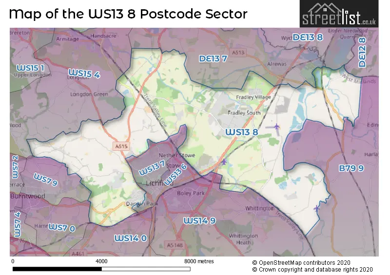
The WS13 8 Postcode shares a border with WS7 0 (BURNTWOOD, Hammerwich), WS13 7 (LICHFIELD), WS14 0 (LICHFIELD, Shenstone, Weeford), WS14 9 (LICHFIELD, Whittington, Whittington Barracks), B79 9 (Elford, Edingale, Wigginton), DE12 8 (Netherseal, Walton-on-Trent, Coton-in-the-Elms), DE13 7 (Alrewas, Kings Bromley), DE13 8 (Barton Under Needwood, Yoxall, Newborough), WS13 6 (LICHFIELD), WS15 4 (RUGELEY, Armitage, Handsacre) and WS7 9 (BURNTWOOD).
The sector is within the post town of LICHFIELD.
WS13 8 is a postcode sector within the WS13 postcode district which is within the WS Walsall postcode area.
The Royal Mail delivery office for the WS13 8 postal sector is the Lichfield Delivery Office.
The area of the WS13 8 postcode sector is 22.33 square miles which is 57.84 square kilometres or 14,293.05 square acres.
The WS13 8 postcode sector is crossed by the A38 Major A road.
Waterways within the WS13 8 postcode sector include the Coventry Canal, Trent & Mersey Canal, Wood End Lock, Lichfield Canal (Wyrley & Essington Extension), Middle Lock, Shadehouse Lock.

Map of the WS13 8 Postcode Sector
Explore the WS13 8 postcode sector by using our free interactive map.
| W | S | 1 | 3 | - | 8 | X | X |
| W | S | 1 | 3 | Space | 8 | Letter | Letter |
Official List of Streets
LICHFIELD (83 Streets)
Fradley (81 Streets)
Streethay (55 Streets)
Fradley Park (6 Streets)
Huddlesford (2 Streets)
Pipehill (3 Streets)
Whittington (1 Streets)
Farewell (2 Streets)
Croxall (1 Streets)
Fisherwick Wood (1 Streets)
Chorley (3 Streets)
Elmhurst (2 Streets)
Bromley Hayes (2 Streets)
Curborough (2 Streets)
Unofficial Streets or Alternative Spellings
Elford
BURTON ROADLICHFIELD
BROADBENT CLOSE CATERBANCK WAY DEYKIN ROAD EASTERN AVENUE FALKLAND ROAD FRIARY GARDENS FRIARY ROAD LARKIN AVENUE MADDOCKE WALK NETHERSTOWE LANE STATHAM STREET WALL LANE WATERY LANE ACTON COURT CAMSEY LANE CATHEDRAL WALK CUT-THROUGH DARWIN PARK FEATHERBED LANE FENN PLACE FLAGPOLE CORNER FRADLEY HAIRPIN GINETA GROVE GINNETTA GROVE HALIFAX CLOSE HILL TOP ROAD HOBSTONE HILL LANE LIMBURG AVENUE MARSHALL ROAD NANSEAWEN ROAD OAKDENE CRESCENT OLD BURTON ROAD PERRY AEVNUE POWELL DRIVE RIDGET LANE SEEDY MILL LANE SHENSTONE STRAIGHT SPADE GREEN ST MATTHEWS ROAD STARTLINE STRAIGHT TAYLOR WAY THE MEADOWS THE MOLEHILL THE ROCHE WESTERN BY-PASS WIGHART DRIVE WOODSIDE WRIGHT CLOSEAlrewas
DAISY LANE FOX LANE RYKNELD STREET SALE LANERUGELEY
GOOSEMOOR GREEN TUPPENHURST LANEArmitage
LICHFIELD ROADMuckley Corner
WALSALL ROADBURNTWOOD
CHORLEY ROADWeather Forecast for WS13 8
Press Button to Show Forecast for Lichfield
| Time Period | Icon | Description | Temperature | Rain Probability | Wind |
|---|---|---|---|---|---|
| 06:00 to 09:00 | Sunny day | 3.0°C (feels like 0.0°C) | 0.00% | NW 4 mph | |
| 09:00 to 12:00 | Sunny day | 7.0°C (feels like 6.0°C) | 0.00% | W 7 mph | |
| 12:00 to 15:00 | Cloudy | 11.0°C (feels like 9.0°C) | 5.00% | W 9 mph | |
| 15:00 to 18:00 | Cloudy | 10.0°C (feels like 8.0°C) | 47.00% | W 11 mph | |
| 18:00 to 21:00 | Overcast | 9.0°C (feels like 6.0°C) | 17.00% | WSW 11 mph | |
| 21:00 to 00:00 | Cloudy | 9.0°C (feels like 6.0°C) | 51.00% | WSW 16 mph |
Press Button to Show Forecast for Lichfield
| Time Period | Icon | Description | Temperature | Rain Probability | Wind |
|---|---|---|---|---|---|
| 00:00 to 03:00 | Light rain | 9.0°C (feels like 6.0°C) | 51.00% | W 13 mph | |
| 03:00 to 06:00 | Overcast | 9.0°C (feels like 6.0°C) | 47.00% | WNW 13 mph | |
| 06:00 to 09:00 | Cloudy | 8.0°C (feels like 5.0°C) | 14.00% | WNW 13 mph | |
| 09:00 to 12:00 | Cloudy | 10.0°C (feels like 6.0°C) | 34.00% | NW 18 mph | |
| 12:00 to 15:00 | Cloudy | 11.0°C (feels like 8.0°C) | 48.00% | NW 18 mph | |
| 15:00 to 18:00 | Cloudy | 11.0°C (feels like 8.0°C) | 5.00% | NW 18 mph | |
| 18:00 to 21:00 | Cloudy | 10.0°C (feels like 8.0°C) | 6.00% | NW 13 mph | |
| 21:00 to 00:00 | Partly cloudy (night) | 7.0°C (feels like 5.0°C) | 2.00% | N 9 mph |
Press Button to Show Forecast for Lichfield
| Time Period | Icon | Description | Temperature | Rain Probability | Wind |
|---|---|---|---|---|---|
| 00:00 to 03:00 | Clear night | 5.0°C (feels like 3.0°C) | 4.00% | NNE 7 mph | |
| 03:00 to 06:00 | Clear night | 3.0°C (feels like 1.0°C) | 3.00% | N 4 mph | |
| 06:00 to 09:00 | Sunny day | 3.0°C (feels like 1.0°C) | 1.00% | NNW 7 mph | |
| 09:00 to 12:00 | Sunny day | 7.0°C (feels like 5.0°C) | 1.00% | N 7 mph | |
| 12:00 to 15:00 | Cloudy | 10.0°C (feels like 8.0°C) | 4.00% | N 7 mph | |
| 15:00 to 18:00 | Cloudy | 11.0°C (feels like 9.0°C) | 5.00% | NNE 7 mph | |
| 18:00 to 21:00 | Sunny day | 10.0°C (feels like 8.0°C) | 2.00% | NE 7 mph | |
| 21:00 to 00:00 | Clear night | 6.0°C (feels like 5.0°C) | 1.00% | NNE 4 mph |
Press Button to Show Forecast for Lichfield
| Time Period | Icon | Description | Temperature | Rain Probability | Wind |
|---|---|---|---|---|---|
| 00:00 to 03:00 | Clear night | 5.0°C (feels like 3.0°C) | 1.00% | NNE 4 mph | |
| 03:00 to 06:00 | Partly cloudy (night) | 4.0°C (feels like 2.0°C) | 2.00% | N 4 mph | |
| 06:00 to 09:00 | Cloudy | 5.0°C (feels like 3.0°C) | 5.00% | N 4 mph | |
| 09:00 to 12:00 | Overcast | 8.0°C (feels like 6.0°C) | 11.00% | N 7 mph | |
| 12:00 to 15:00 | Overcast | 10.0°C (feels like 8.0°C) | 9.00% | NNE 7 mph | |
| 15:00 to 18:00 | Overcast | 11.0°C (feels like 9.0°C) | 10.00% | NNE 9 mph | |
| 18:00 to 21:00 | Overcast | 11.0°C (feels like 9.0°C) | 10.00% | NNE 7 mph | |
| 21:00 to 00:00 | Cloudy | 9.0°C (feels like 7.0°C) | 7.00% | NE 7 mph |
Schools and Places of Education Within the WS13 8 Postcode Sector
Christ Church CofE (C) Primary School
Voluntary controlled school
Christ Church Lane, Lichfield, Staffordshire, WS13 8AY
Head: Mrs CC Pilmore
Ofsted Rating: Good
Inspection: 2023-10-18 (183 days ago)
Website: Visit Christ Church CofE (C) Primary School Website
Phone: 01543227210
Number of Pupils: 418
Maple Hayes Hall School
Other independent special school
Abnalls Lane, Lichfield, Staffordshire, WS13 8BL
Head: Mr David Lowe
Ofsted Rating: Good
Inspection: 2022-03-03 (777 days ago)
Website: Visit Maple Hayes Hall School Website
Phone: 01543264387
Number of Pupils: 112
St Stephen's Primary School
Community school
Church Lane, Lichfield, Staffordshire, WS13 8NL
Head: Mr Mike Dowd
Ofsted Rating: Good
Inspection: 2022-11-16 (519 days ago)
Website: Visit St Stephen's Primary School Website
Phone: 01283790268
Number of Pupils: 289
House Prices in the WS13 8 Postcode Sector
| Type of Property | 2018 Average | 2018 Sales | 2017 Average | 2017 Sales | 2016 Average | 2016 Sales | 2015 Average | 2015 Sales |
|---|---|---|---|---|---|---|---|---|
| Detached | £398,189 | 160 | £373,940 | 124 | £373,586 | 61 | £357,476 | 64 |
| Semi-Detached | £262,299 | 99 | £250,541 | 55 | £239,818 | 11 | £245,897 | 15 |
| Terraced | £217,572 | 75 | £203,378 | 57 | £241,124 | 37 | £221,529 | 35 |
| Flats | £136,579 | 12 | £131,871 | 12 | £128,700 | 10 | £128,908 | 6 |
Important Postcodes WS13 8 in the Postcode Sector
WS13 8AY is the postcode for CHRIST CHURCH CHURCH OF ENGLAND PRIMARY SCHOOL, CHRISTCHURCH LANE, LICHFIELD, Christ Church C of E Primary School, Christ Church Lane, and Christ Church Church Of England Primary School, Christchurch Lane
WS13 8FT is the postcode for Streethay Primary School, Yoxall Way, and STREETHAY PRIMARY SCHOOL, YOXALL WAY, STREETHAY
WS13 8NL is the postcode for St. Stephens Primary School, Church Lane, Fradley, and St. Stephens Primary School, Church Lane
WS13 8RR is the postcode for Sentinel House, 9 Wellington Crescent, Fradley Park, and Sentinel House, 9 Wellington Crescent
| The WS13 8 Sector is within these Local Authorities |
|
|---|---|
| The WS13 8 Sector is within these Counties |
|
| The WS13 8 Sector is within these Water Company Areas |
|