The WS15 2 postcode sector is within the county of Staffordshire.
Did you know? According to the 2021 Census, the WS15 2 postcode sector is home to a bustling 14,424 residents!
Given that each sector allows for 400 unique postcode combinations. Letters C, I, K, M, O and V are not allowed in the last two letters of a postcode. With 332 postcodes already in use, this leaves 68 units available.
The WS15 2 postal code covers the settlement of RUGELEY.
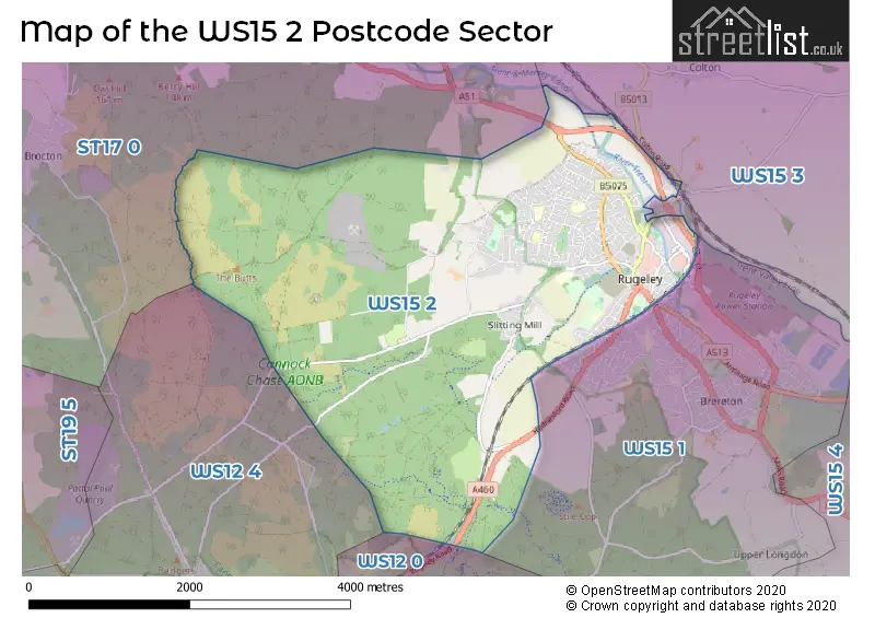
The WS15 2 Postcode shares a border with WS15 1 (Brereton, RUGELEY, Hawksyard), ST17 0 (STAFFORD, Brocton, Acton Trussell), WS12 4 (Hednesford, CANNOCK, Huntington), WS15 3 (Abbots Bromley, RUGELEY, Hill Ridware) and WS12 0 (CANNOCK, Hednesford, Hazel Slade).
The sector is within the post town of RUGELEY.
WS15 2 is a postcode sector within the WS15 postcode district which is within the WS Walsall postcode area.
The Royal Mail delivery office for the WS15 2 postal sector is the Rugeley Delivery Office.
The area of the WS15 2 postcode sector is 7.92 square miles which is 20.52 square kilometres or 5,071.19 square acres.
Waterways within the WS15 2 postcode sector include the River Trent, Trent & Mersey Canal.

Map of the WS15 2 Postcode Sector
Explore the WS15 2 postcode sector by using our free interactive map.
| W | S | 1 | 5 | - | 2 | X | X |
| W | S | 1 | 5 | Space | 2 | Letter | Letter |
Official List of Streets
RUGELEY (229 Streets)
Unofficial Streets or Alternative Spellings
RUGELEY
BISHOPS GRANGE DEACONS WAY VICARS CROFT ALEN BRIT WALK ARE WE THERE YET? AUNT FLOW BACK LANE BEES LANE BILLY GOATS GRUFF BOMB HOLE BRAKELY CLOSE BREEZE THE TREES BROOKSIDE BYRON CLOSE CAMBRIAN MEWS CHURCHCROFT GARDENS CROSS CHASE WALK DEANERY CLOSE DEVILS STAIRCASE FORGE NEWS GREEN CLOSE GREENFIELD DRIVE HERITAGE TRAIL HERON COURT HERON STREET BACK ROAD HIGH RIDGE HIGH VOLTAGE JENNIE LEE PLACE JENNIE LEE WAY KITBAG HILL LET LOOSE LICHFIELD ROAD LITTLE ORCHARD LOWER CLIFF LUNG BUSTER MOORS GORSE BRIDGE OAK CLOSE OGRE THE HILL PAIN IN THE HARDTAIL PARSONS SLADE PENK DRIVE SOUTH PENKRIDGE BANK PENNY BANK COURT PEPPER SLADE RIVERSIDE ROSE WAY RUGELEY EASTERN BY-PASS SAINT ANTHONYS CLOSE SAINT PAULS ROAD SCHOOL ROAD SNAKES N ADDERS SNOW WHITE SON OF CHAINSLAPPER SOUTH STREET SPRINGFIELDS ROAD STEGOSAURUS TALBOT STREET BACK ROAD TALBOT STREET LINK ROAD THE BLOODY STEPS THE SEVEN DWARFS TIGHT SQUEEZE TRENT VALLEY TRADING ESTATE TWIST & SHOUT UNCLE ARTHUR WATCH OUT TROLLS! WEREWOLF DROP WHITWORTH LANE WINSTANLEY CLOSE ZIG ZAKBrereton
ARCH STREET POWER STATION ROADBellamour
COLTON ROADHednesford
RUGELEY ROADCANNOCK
MARQUISS DRIVEWeather Forecast for WS15 2
Press Button to Show Forecast for Follow The Dog Trail
| Time Period | Icon | Description | Temperature | Rain Probability | Wind |
|---|---|---|---|---|---|
| 06:00 to 09:00 | Light rain | 4.0°C (feels like 1.0°C) | 50.00% | WSW 7 mph | |
| 09:00 to 12:00 | Cloudy | 7.0°C (feels like 5.0°C) | 11.00% | NW 9 mph | |
| 12:00 to 15:00 | Cloudy | 8.0°C (feels like 5.0°C) | 46.00% | NW 11 mph | |
| 15:00 to 18:00 | Cloudy | 8.0°C (feels like 6.0°C) | 43.00% | NNE 7 mph | |
| 18:00 to 21:00 | Cloudy | 7.0°C (feels like 6.0°C) | 6.00% | E 4 mph | |
| 21:00 to 00:00 | Cloudy | 5.0°C (feels like 4.0°C) | 8.00% | NE 4 mph |
Press Button to Show Forecast for Follow The Dog Trail
| Time Period | Icon | Description | Temperature | Rain Probability | Wind |
|---|---|---|---|---|---|
| 00:00 to 03:00 | Cloudy | 4.0°C (feels like 2.0°C) | 6.00% | ENE 4 mph | |
| 03:00 to 06:00 | Cloudy | 3.0°C (feels like 1.0°C) | 4.00% | E 4 mph | |
| 06:00 to 09:00 | Cloudy | 3.0°C (feels like 0.0°C) | 5.00% | ENE 4 mph | |
| 09:00 to 12:00 | Cloudy | 6.0°C (feels like 4.0°C) | 5.00% | ENE 7 mph | |
| 12:00 to 15:00 | Overcast | 8.0°C (feels like 7.0°C) | 10.00% | E 4 mph | |
| 15:00 to 18:00 | Cloudy | 9.0°C (feels like 8.0°C) | 9.00% | ENE 4 mph | |
| 18:00 to 21:00 | Cloudy | 8.0°C (feels like 7.0°C) | 8.00% | ENE 4 mph | |
| 21:00 to 00:00 | Partly cloudy (night) | 5.0°C (feels like 2.0°C) | 7.00% | E 7 mph |
Press Button to Show Forecast for Follow The Dog Trail
| Time Period | Icon | Description | Temperature | Rain Probability | Wind |
|---|---|---|---|---|---|
| 00:00 to 03:00 | Partly cloudy (night) | 3.0°C (feels like 1.0°C) | 7.00% | ENE 7 mph | |
| 03:00 to 06:00 | Cloudy | 2.0°C (feels like 0.0°C) | 11.00% | ENE 7 mph | |
| 06:00 to 09:00 | Cloudy | 4.0°C (feels like 1.0°C) | 9.00% | ENE 7 mph | |
| 09:00 to 12:00 | Cloudy | 7.0°C (feels like 5.0°C) | 12.00% | E 9 mph | |
| 12:00 to 15:00 | Overcast | 9.0°C (feels like 7.0°C) | 20.00% | E 9 mph | |
| 15:00 to 18:00 | Overcast | 10.0°C (feels like 7.0°C) | 22.00% | ENE 11 mph | |
| 18:00 to 21:00 | Cloudy | 9.0°C (feels like 7.0°C) | 18.00% | ENE 9 mph | |
| 21:00 to 00:00 | Cloudy | 7.0°C (feels like 4.0°C) | 20.00% | NE 11 mph |
Press Button to Show Forecast for Follow The Dog Trail
| Time Period | Icon | Description | Temperature | Rain Probability | Wind |
|---|---|---|---|---|---|
| 00:00 to 03:00 | Cloudy | 6.0°C (feels like 3.0°C) | 20.00% | NE 11 mph | |
| 03:00 to 06:00 | Light rain | 6.0°C (feels like 2.0°C) | 49.00% | NE 11 mph | |
| 06:00 to 09:00 | Heavy rain | 6.0°C (feels like 3.0°C) | 77.00% | NNE 11 mph | |
| 09:00 to 12:00 | Light rain | 7.0°C (feels like 5.0°C) | 57.00% | NNE 9 mph | |
| 12:00 to 15:00 | Heavy rain | 9.0°C (feels like 6.0°C) | 76.00% | N 11 mph | |
| 15:00 to 18:00 | Light rain | 9.0°C (feels like 6.0°C) | 54.00% | N 11 mph | |
| 18:00 to 21:00 | Overcast | 9.0°C (feels like 7.0°C) | 19.00% | NW 9 mph | |
| 21:00 to 00:00 | Partly cloudy (night) | 7.0°C (feels like 5.0°C) | 10.00% | WNW 7 mph |
Schools and Places of Education Within the WS15 2 Postcode Sector
Chancel Primary School
Community school
Wolseley Road, Rugeley, Staffordshire, WS15 2EW
Head: Mrs Tina Blankley
Ofsted Rating: Good
Inspection: 2019-10-02 (1667 days ago)
Website: Visit Chancel Primary School Website
Phone: 01889228710
Number of Pupils: 213
Churchfield CofE Primary Academy
Academy converter
Sandy Lane, Rugeley, Staffordshire, WS15 2LB
Head: Mr Chris Dobson
Ofsted Rating: Good
Inspection: 2023-09-28 (210 days ago)
Website: Visit Churchfield CofE Primary Academy Website
Phone: 01889224520
Number of Pupils: 138
Etching Hill CofE Primary Academy
Academy converter
Penk Drive, Rugeley, Staffordshire, WS15 2XY
Head: Mrs Marie Smith
Ofsted Rating: Good
Inspection: 2023-12-14 (133 days ago)
Website: Visit Etching Hill CofE Primary Academy Website
Phone: 01889221864
Number of Pupils: 449
Forest Hills Primary School
Academy sponsor led
School Road, Rugeley, Staffordshire, WS15 2PD
Head: Mrs Sarah Powell (Headteacher)
Ofsted Rating: Requires improvement
Inspection: 2023-09-13 (225 days ago)
Website: Visit Forest Hills Primary School Website
Phone: 01889370020
Number of Pupils: 100
JP Alternative Education
Other independent school
Shooting Butts Centre, Rugeley, Staffordshire, WS15 2UB
Head: Mr Julian Porter
Ofsted Rating: Good
Inspection: 2023-10-19 (189 days ago)
Website: Visit JP Alternative Education Website
Phone: 01889582864
Number of Pupils: 20
The Hart School
Academy sponsor led
Penkridge Bank Road, Rugeley, Staffordshire, WS15 2UE
Head: Miss Rachael Sandham
Ofsted Rating: Good
Inspection: 2023-06-22 (308 days ago)
Website: Visit The Hart School Website
Phone: 01889802440
Number of Pupils: 1265
The John Bamford Primary School
Community school
Crabtree Way, Rugeley, Staffordshire, WS15 2PA
Head: Mrs Louise Ferguson
Ofsted Rating: Good
Inspection: 2018-10-16 (2018 days ago)
Website: Visit The John Bamford Primary School Website
Phone: 01889228689
Number of Pupils: 303
House Prices in the WS15 2 Postcode Sector
| Type of Property | 2018 Average | 2018 Sales | 2017 Average | 2017 Sales | 2016 Average | 2016 Sales | 2015 Average | 2015 Sales |
|---|---|---|---|---|---|---|---|---|
| Detached | £272,425 | 70 | £259,914 | 88 | £247,920 | 77 | £222,301 | 68 |
| Semi-Detached | £163,179 | 85 | £151,687 | 68 | £146,635 | 73 | £140,998 | 64 |
| Terraced | £147,134 | 66 | £144,116 | 56 | £133,201 | 72 | £132,846 | 73 |
| Flats | £88,917 | 6 | £85,050 | 10 | £111,500 | 5 | £81,350 | 10 |
Important Postcodes WS15 2 in the Postcode Sector
WS15 2AA is the postcode for BEAUMONT BLOCK, Rugeley Sixth Form Academy, Taylors Lane, Rugeley Sixth Form Academy, Taylors Lane, Rugeley Rose Theatre and Community Hall, Taylors Lane, and PHOENIX BLOCK, Rugeley Sixth Form Academy, Taylors Lane
WS15 2BQ is the postcode for Staffordshire Police, Rugeley Police Station, Anson Street
WS15 2EW is the postcode for Chancel County Infants School, Wolseley Road
WS15 2FH is the postcode for Springfields Health And Wellbeing Centre, Lovett Court
WS15 2FX is the postcode for Staffordshire Magistrates Courts Committee, The Court House, Bryans Lane
WS15 2HX is the postcode for Staffordshire County Council, Rugeley Youth & Community Centre, Burnthill Lane
WS15 2HZ is the postcode for HUMANITIES BLOCK, The Hart School Upper, Burnthill Lane, RUGELEY LEISURE CENTRE, BURNTHILL LANE, Leisure Centre, Burnthill Lane, and The Hart School Upper, Burnthill Lane
WS15 2JN is the postcode for Staffordshire Fire & Rescue Service, Fire Station, Bryans Lane
WS15 2LB is the postcode for CHURCHFIELD CE PRIMARY ACADEMY, SANDY LANE, RUGELEY, Churchfield C.E. Primary Academy, Sandy Lane, and Sandy Lane Health Centre, Sandy Lane
WS15 2PA is the postcode for The John Bamford Primary School, Crabtree Way, Etchinghill, and John Bamford County Primary School, Crabtree Way
WS15 2PD is the postcode for FOREST HILLS PRIMARY, School Road, and Western Springs Primary School, Springfields Estate
WS15 2QD is the postcode for Springfields Health & Wellbeing Centre, Lovett Court, and SPRINGFIELD WELLBEING CENTRE, Springfields Health & Wellbeing Centre, Lovett Court
WS15 2UE is the postcode for The Hart School - Lower, Penkridge Bank Road, The Hart School, Penkridge Bank Road, ANSON BLOCK, The Hart School - Lower, Penkridge Bank Road, D&T BLOCK, The Hart School - Lower, Penkridge Bank Road, MAIN BLOCK, The Hart School - Lower, Penkridge Bank Road, and SPORTS BLOCK, The Hart School - Lower, Penkridge Bank Road
WS15 2XY is the postcode for Etching Hill CE Primary Academy, Penk Drive North, Etching Hill, and Staffordshire County Council, Etching Hill C E Primary School, Penk Drive North
| The WS15 2 Sector is within these Local Authorities |
|
|---|---|
| The WS15 2 Sector is within these Counties |
|
| The WS15 2 Sector is within these Water Company Areas |
|
Tourist Attractions within the WS15 2 Postcode Area
We found 1 visitor attractions within the WS15 postcode area
| Go Ape! Tree Top Adventure - Cannock Forest |
|---|
| Country Parks |
| Country Park |
| View Go Ape! Tree Top Adventure - Cannock Forest on Google Maps |