The WS4 2 postcode sector is within the county of West Midlands.
Did you know? According to the 2021 Census, the WS4 2 postcode sector is home to a bustling 4,761 residents!
Given that each sector allows for 400 unique postcode combinations. Letters C, I, K, M, O and V are not allowed in the last two letters of a postcode. With 103 postcodes already in use, this leaves 297 units available.
The WS4 2 postal code covers the settlement of WALSALL.
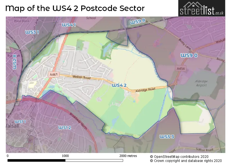
The WS4 2 Postcode shares a border with WS1 1 (WALSALL), WS1 2 (WALSALL), WS2 8 (WALSALL, Birchills), WS5 3 (WALSALL), WS9 0 (WALSALL, Aldridge), WS3 1 (WALSALL) and WS4 1 (WALSALL, Rushall, Shelfield).
The sector is within the post town of WALSALL.
WS4 2 is a postcode sector within the WS4 postcode district which is within the WS Walsall postcode area.
The Royal Mail delivery office for the WS4 2 postal sector is the Walsall Delivery Office.
The area of the WS4 2 postcode sector is 1.31 square miles which is 3.39 square kilometres or 836.56 square acres.
Waterways within the WS4 2 postcode sector include the Daw End Branch, Rushall Canal.

Map of the WS4 2 Postcode Sector
Explore the WS4 2 postcode sector by using our free interactive map.
| W | S | 4 | - | 2 | X | X |
| W | S | 4 | Space | 2 | Letter | Letter |
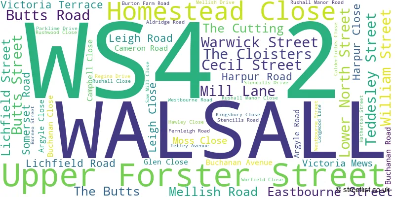
Official List of Streets
WALSALL (56 Streets)
Unofficial Streets or Alternative Spellings
Weather Forecast for WS4 2
Press Button to Show Forecast for Rushall (West Midlands)
| Time Period | Icon | Description | Temperature | Rain Probability | Wind |
|---|---|---|---|---|---|
| 03:00 to 06:00 | Clear night | 2.0°C (feels like -1.0°C) | 0.00% | NNW 4 mph | |
| 06:00 to 09:00 | Sunny day | 2.0°C (feels like -1.0°C) | 0.00% | NW 4 mph | |
| 09:00 to 12:00 | Sunny day | 7.0°C (feels like 5.0°C) | 0.00% | W 4 mph | |
| 12:00 to 15:00 | Cloudy | 10.0°C (feels like 9.0°C) | 6.00% | W 9 mph | |
| 15:00 to 18:00 | Cloudy | 10.0°C (feels like 8.0°C) | 45.00% | W 13 mph | |
| 18:00 to 21:00 | Overcast | 9.0°C (feels like 6.0°C) | 17.00% | WSW 11 mph | |
| 21:00 to 00:00 | Cloudy | 9.0°C (feels like 5.0°C) | 17.00% | WSW 13 mph |
Press Button to Show Forecast for Rushall (West Midlands)
| Time Period | Icon | Description | Temperature | Rain Probability | Wind |
|---|---|---|---|---|---|
| 00:00 to 03:00 | Overcast | 9.0°C (feels like 6.0°C) | 22.00% | W 13 mph | |
| 03:00 to 06:00 | Overcast | 9.0°C (feels like 5.0°C) | 45.00% | WNW 13 mph | |
| 06:00 to 09:00 | Overcast | 8.0°C (feels like 4.0°C) | 47.00% | WNW 13 mph | |
| 09:00 to 12:00 | Overcast | 9.0°C (feels like 5.0°C) | 10.00% | NW 16 mph | |
| 12:00 to 15:00 | Cloudy | 10.0°C (feels like 7.0°C) | 48.00% | NW 18 mph | |
| 15:00 to 18:00 | Cloudy | 11.0°C (feels like 7.0°C) | 5.00% | NNW 18 mph | |
| 18:00 to 21:00 | Cloudy | 9.0°C (feels like 6.0°C) | 6.00% | NNW 13 mph | |
| 21:00 to 00:00 | Partly cloudy (night) | 7.0°C (feels like 4.0°C) | 2.00% | NNW 9 mph |
Press Button to Show Forecast for Rushall (West Midlands)
| Time Period | Icon | Description | Temperature | Rain Probability | Wind |
|---|---|---|---|---|---|
| 00:00 to 03:00 | Clear night | 5.0°C (feels like 3.0°C) | 4.00% | NNE 7 mph | |
| 03:00 to 06:00 | Partly cloudy (night) | 3.0°C (feels like 1.0°C) | 3.00% | N 4 mph | |
| 06:00 to 09:00 | Sunny day | 3.0°C (feels like 0.0°C) | 1.00% | N 7 mph | |
| 09:00 to 12:00 | Sunny day | 6.0°C (feels like 4.0°C) | 1.00% | N 7 mph | |
| 12:00 to 15:00 | Cloudy | 9.0°C (feels like 8.0°C) | 4.00% | N 7 mph | |
| 15:00 to 18:00 | Cloudy | 11.0°C (feels like 9.0°C) | 5.00% | NNE 7 mph | |
| 18:00 to 21:00 | Sunny day | 9.0°C (feels like 7.0°C) | 2.00% | NE 9 mph | |
| 21:00 to 00:00 | Clear night | 6.0°C (feels like 4.0°C) | 1.00% | NE 4 mph |
Press Button to Show Forecast for Rushall (West Midlands)
| Time Period | Icon | Description | Temperature | Rain Probability | Wind |
|---|---|---|---|---|---|
| 00:00 to 03:00 | Clear night | 4.0°C (feels like 3.0°C) | 1.00% | NE 4 mph | |
| 03:00 to 06:00 | Partly cloudy (night) | 3.0°C (feels like 1.0°C) | 2.00% | NNE 4 mph | |
| 06:00 to 09:00 | Cloudy | 4.0°C (feels like 2.0°C) | 6.00% | N 4 mph | |
| 09:00 to 12:00 | Cloudy | 8.0°C (feels like 6.0°C) | 8.00% | N 7 mph | |
| 12:00 to 15:00 | Overcast | 10.0°C (feels like 8.0°C) | 8.00% | NNE 9 mph | |
| 15:00 to 18:00 | Overcast | 11.0°C (feels like 9.0°C) | 11.00% | NNE 9 mph | |
| 18:00 to 21:00 | Overcast | 10.0°C (feels like 9.0°C) | 10.00% | NNE 7 mph | |
| 21:00 to 00:00 | Cloudy | 8.0°C (feels like 6.0°C) | 7.00% | NE 7 mph |
Schools and Places of Education Within the WS4 2 Postcode Sector
Butts Primary School
Community school
Butts Road, Walsall, West Midlands, WS4 2AH
Head: Mrs Angela Hill
Ofsted Rating: Good
Inspection: 2019-02-06 (1898 days ago)
Website: Visit Butts Primary School Website
Phone: 01922721073
Number of Pupils: 248
Queen Mary's High School
Academy converter
Upper Forster Street, Walsall, West Midlands, WS4 2AE
Head: Mrs Nicola Daniel
Ofsted Rating: Outstanding
Inspection: 2021-10-13 (918 days ago)
Website: Visit Queen Mary's High School Website
Phone: 01922721013
Number of Pupils: 908
House Prices in the WS4 2 Postcode Sector
| Type of Property | 2018 Average | 2018 Sales | 2017 Average | 2017 Sales | 2016 Average | 2016 Sales | 2015 Average | 2015 Sales |
|---|---|---|---|---|---|---|---|---|
| Detached | £332,965 | 26 | £312,591 | 23 | £277,158 | 30 | £286,315 | 26 |
| Semi-Detached | £241,066 | 22 | £212,650 | 19 | £237,423 | 13 | £221,355 | 11 |
| Terraced | £141,791 | 17 | £142,321 | 14 | £155,550 | 9 | £139,313 | 13 |
| Flats | £97,900 | 10 | £96,977 | 22 | £98,600 | 10 | £76,041 | 11 |
Important Postcodes WS4 2 in the Postcode Sector
WS4 2AE is the postcode for Queen Marys High School, Upper Forster Street, MAIN BUILDING, Queen Marys High School, Upper Forster Street, and WOOTTON & MATHS BLOCK, Queen Marys High School, Upper Forster Street
WS4 2AH is the postcode for Butts Primary School, Teddesley Street
WS4 2DH is the postcode for The Hollies, 10 Lichfield Road, and 10, Lichfield Road
| The WS4 2 Sector is within these Local Authorities |
|
|---|---|
| The WS4 2 Sector is within these Counties |
|
| The WS4 2 Sector is within these Water Company Areas |
|