The WS7 4 postcode sector is within the county of Staffordshire.
Did you know? According to the 2021 Census, the WS7 4 postcode sector is home to a bustling 7,277 residents!
Given that each sector allows for 400 unique postcode combinations. Letters C, I, K, M, O and V are not allowed in the last two letters of a postcode. With 115 postcodes already in use, this leaves 285 units available.
The largest settlements in the WS7 4 postal code are BURNTWOOD and Chasetown.
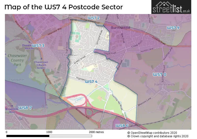
The WS7 4 Postcode shares a border with WS7 0 (BURNTWOOD, Hammerwich), WS7 2 (BURNTWOOD, Chase Terrace), WS8 6 (Brownhills, WALSALL), WS8 7 (WALSALL, Brownhills, Clayhanger) and WS7 3 (BURNTWOOD, Chasetown, Burntwood Business Park).
The sector is within the post town of BURNTWOOD.
WS7 4 is a postcode sector within the WS7 postcode district which is within the WS Walsall postcode area.
The Royal Mail delivery office for the WS7 4 postal sector is the Lichfield Delivery Office.
The area of the WS7 4 postcode sector is 0.96 square miles which is 2.50 square kilometres or 617.27 square acres.
The WS7 4 postcode sector is crossed by the M6 motorway.

Map of the WS7 4 Postcode Sector
Explore the WS7 4 postcode sector by using our free interactive map.
| W | S | 7 | - | 4 | X | X |
| W | S | 7 | Space | 4 | Letter | Letter |
Official List of Streets
BURNTWOOD (76 Streets)
Unofficial Streets or Alternative Spellings
BURNTWOOD
BRIDGE CROSS ROAD GRANGE AVENUE MILESTONE WAY PARK ROAD ALLEYWAY ASHGROVE BLACKTHORN AVENUE DAVEY CLOSE OAK VALE PEAKES LANE TREWNERN DRIVEHammerwich
MEERASH LANEBrownhills
OGLEY HAY ROADWeather Forecast for WS7 4
Press Button to Show Forecast for Brownhills
| Time Period | Icon | Description | Temperature | Rain Probability | Wind |
|---|---|---|---|---|---|
| 06:00 to 09:00 | Cloudy | 8.0°C (feels like 5.0°C) | 17.00% | NW 13 mph | |
| 09:00 to 12:00 | Light rain shower (day) | 9.0°C (feels like 5.0°C) | 41.00% | NW 18 mph | |
| 12:00 to 15:00 | Cloudy | 11.0°C (feels like 7.0°C) | 17.00% | NW 18 mph | |
| 15:00 to 18:00 | Cloudy | 10.0°C (feels like 7.0°C) | 49.00% | NNW 16 mph | |
| 18:00 to 21:00 | Light rain shower (day) | 9.0°C (feels like 6.0°C) | 36.00% | N 9 mph | |
| 21:00 to 00:00 | Cloudy | 6.0°C (feels like 4.0°C) | 5.00% | NE 7 mph |
Press Button to Show Forecast for Brownhills
| Time Period | Icon | Description | Temperature | Rain Probability | Wind |
|---|---|---|---|---|---|
| 00:00 to 03:00 | Partly cloudy (night) | 4.0°C (feels like 2.0°C) | 1.00% | NNE 4 mph | |
| 03:00 to 06:00 | Clear night | 3.0°C (feels like 1.0°C) | 1.00% | NNW 4 mph | |
| 06:00 to 09:00 | Partly cloudy (day) | 3.0°C (feels like 0.0°C) | 1.00% | NNW 7 mph | |
| 09:00 to 12:00 | Sunny day | 7.0°C (feels like 4.0°C) | 1.00% | N 7 mph | |
| 12:00 to 15:00 | Overcast | 10.0°C (feels like 8.0°C) | 8.00% | N 9 mph | |
| 15:00 to 18:00 | Overcast | 10.0°C (feels like 9.0°C) | 8.00% | N 7 mph | |
| 18:00 to 21:00 | Overcast | 10.0°C (feels like 9.0°C) | 9.00% | NNE 4 mph | |
| 21:00 to 00:00 | Partly cloudy (night) | 6.0°C (feels like 5.0°C) | 2.00% | NE 4 mph |
Press Button to Show Forecast for Brownhills
| Time Period | Icon | Description | Temperature | Rain Probability | Wind |
|---|---|---|---|---|---|
| 00:00 to 03:00 | Clear night | 4.0°C (feels like 3.0°C) | 1.00% | NE 4 mph | |
| 03:00 to 06:00 | Clear night | 3.0°C (feels like 2.0°C) | 1.00% | NNW 4 mph | |
| 06:00 to 09:00 | Cloudy | 4.0°C (feels like 2.0°C) | 5.00% | NW 4 mph | |
| 09:00 to 12:00 | Overcast | 8.0°C (feels like 6.0°C) | 10.00% | N 4 mph | |
| 12:00 to 15:00 | Cloudy | 10.0°C (feels like 8.0°C) | 9.00% | NNE 9 mph | |
| 15:00 to 18:00 | Overcast | 10.0°C (feels like 8.0°C) | 11.00% | NE 9 mph | |
| 18:00 to 21:00 | Partly cloudy (day) | 9.0°C (feels like 8.0°C) | 3.00% | NE 9 mph | |
| 21:00 to 00:00 | Partly cloudy (night) | 6.0°C (feels like 4.0°C) | 3.00% | NE 7 mph |
Press Button to Show Forecast for Brownhills
| Time Period | Icon | Description | Temperature | Rain Probability | Wind |
|---|---|---|---|---|---|
| 00:00 to 03:00 | Cloudy | 4.0°C (feels like 2.0°C) | 6.00% | NE 7 mph | |
| 03:00 to 06:00 | Partly cloudy (night) | 3.0°C (feels like 1.0°C) | 3.00% | NNE 4 mph | |
| 06:00 to 09:00 | Partly cloudy (day) | 4.0°C (feels like 2.0°C) | 3.00% | NNE 4 mph | |
| 09:00 to 12:00 | Cloudy | 7.0°C (feels like 6.0°C) | 7.00% | NE 7 mph | |
| 12:00 to 15:00 | Cloudy | 9.0°C (feels like 7.0°C) | 12.00% | ENE 7 mph | |
| 15:00 to 18:00 | Cloudy | 9.0°C (feels like 7.0°C) | 10.00% | ENE 7 mph | |
| 18:00 to 21:00 | Cloudy | 8.0°C (feels like 6.0°C) | 8.00% | ENE 7 mph | |
| 21:00 to 00:00 | Cloudy | 7.0°C (feels like 5.0°C) | 7.00% | ENE 7 mph |
Schools and Places of Education Within the WS7 4 Postcode Sector
Springhill Primary Academy
Academy sponsor led
Mossbank Avenue, Burntwood, Staffordshire, WS7 4UN
Head: Mr Jack Edwards
Ofsted Rating: Good
Inspection: 2019-06-05 (1780 days ago)
Website: Visit Springhill Primary Academy Website
Phone: 01543225620
Number of Pupils: 193
House Prices in the WS7 4 Postcode Sector
| Type of Property | 2018 Average | 2018 Sales | 2017 Average | 2017 Sales | 2016 Average | 2016 Sales | 2015 Average | 2015 Sales |
|---|---|---|---|---|---|---|---|---|
| Detached | £276,667 | 12 | £240,938 | 17 | £237,958 | 24 | £197,570 | 20 |
| Semi-Detached | £191,426 | 21 | £167,444 | 40 | £146,037 | 46 | £149,289 | 31 |
| Terraced | £136,806 | 44 | £134,726 | 47 | £127,678 | 46 | £118,282 | 46 |
| Flats | £89,900 | 10 | £104,167 | 3 | £85,775 | 8 | £107,488 | 4 |
Important Postcodes WS7 4 in the Postcode Sector
WS7 4QH is the postcode for The Old Mining College, Queen Street
WS7 4RR is the postcode for Staffordshire County Council, Oakdene Day Centre, Sycamore Road
WS7 4TU is the postcode for RIDGEWAY PRIMARY SCHOOL, GRANGE ROAD, BURNTWOOD, and Ridgeway Primary School, Grange Road
WS7 4UN is the postcode for Springhill Academy, Mossbank Avenue, and SPRINGHILL ACADEMY, MOSSBANK AVENUE, STAFFORDSHIRE
| The WS7 4 Sector is within these Local Authorities |
|
|---|---|
| The WS7 4 Sector is within these Counties |
|
| The WS7 4 Sector is within these Water Company Areas |
|