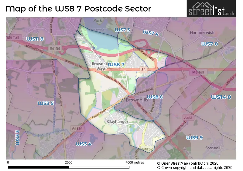
The WS8 7 postcode sector stands on the Staffordshire and West Midlands border.
Did you know? According to the 2021 Census, the WS8 7 postcode sector is home to a bustling 9,727 residents!
Given that each sector allows for 400 unique postcode combinations. Letters C, I, K, M, O and V are not allowed in the last two letters of a postcode. With 186 postcodes already in use, this leaves 214 units available.
The largest settlement in the WS8 7 postal code is WALSALL followed by Brownhills, and Clayhanger.
The WS8 7 Postcode shares a border with WS3 5 (WALSALL, Pelsall), WS7 4 (BURNTWOOD, Chasetown), WS8 6 (Brownhills, WALSALL), WS3 4 (WALSALL, Pelsall), WS7 3 (BURNTWOOD, Chasetown, Burntwood Business Park), WS9 9 (WALSALL, Walsall Wood, Stonnall) and WS11 9 (Norton Canes, CANNOCK).
The sector is within the post town of WALSALL.
WS8 7 is a postcode sector within the WS8 postcode district which is within the WS Walsall postcode area.
The Royal Mail delivery office for the WS8 7 postal sector is the Walsall Delivery Office.
The area of the WS8 7 postcode sector is 2.68 square miles which is 6.95 square kilometres or 1,716.85 square acres.
The WS8 7 postcode sector is crossed by the M6 motorway.
The WS8 7 postcode sector is crossed by the A5 Major A road.
Waterways within the WS8 7 postcode sector include the Daw End Branch Canal, Wyrley & Essington Canal.

Map of the WS8 7 Postcode Sector
Explore the WS8 7 postcode sector by using our free interactive map.
| W | S | 8 | - | 7 | X | X |
| W | S | 8 | Space | 7 | Letter | Letter |
Official List of Streets
WALSALL (76 Streets)
Clayhanger (26 Streets)
Brownhills (30 Streets)
Unofficial Streets or Alternative Spellings
Aldridge
CHESTER ROAD ASH CLOSE ASPEN WAY BESCOT JUNCTION TO WICHNOR JUNCTION (LICHFIELD) LINE BROWNHILLS BUSINESS PARK BULLOWS ROAD COMMON SIDE COPPICE SIDE GREEN LANE HAWTHORN DRIVE HAWTHORNE DRIVE LOCAL CYCLE ROUTE MCCLEAN WAY MIDDLETON RAILWAY AQUEDUCT NORTHFIELDS WAY PARK VIEW DRIVE POOL ROAD PROFITT CLOSE RISING SUN ROUNDABOUT SOUTH STAFFORDSHIRE LINE STREETS CORNER THE PARADE WHITE HORSE ROAD WULFRUN WAYBrownhills
CHASE ROAD CURLEW DRIVEWalsall Wood
COPPICE ROADPelsall
LICHFIELD ROADBURNTWOOD
BURNTWOOD WAYNorton Canes
BLENHEIM ROAD BROWNHILLS ROAD GREYHOUND CROFT RED LION LANE WILLOW ROADWeather Forecast for WS8 7
Press Button to Show Forecast for Brownhills
| Time Period | Icon | Description | Temperature | Rain Probability | Wind |
|---|---|---|---|---|---|
| 21:00 to 00:00 | Cloudy | 5.0°C (feels like 4.0°C) | 6.00% | ENE 4 mph |
Press Button to Show Forecast for Brownhills
| Time Period | Icon | Description | Temperature | Rain Probability | Wind |
|---|---|---|---|---|---|
| 00:00 to 03:00 | Cloudy | 4.0°C (feels like 2.0°C) | 7.00% | ENE 7 mph | |
| 03:00 to 06:00 | Partly cloudy (night) | 3.0°C (feels like 0.0°C) | 1.00% | ENE 4 mph | |
| 06:00 to 09:00 | Partly cloudy (day) | 3.0°C (feels like 0.0°C) | 1.00% | ENE 7 mph | |
| 09:00 to 12:00 | Cloudy | 6.0°C (feels like 4.0°C) | 5.00% | ENE 7 mph | |
| 12:00 to 15:00 | Overcast | 8.0°C (feels like 7.0°C) | 10.00% | ENE 4 mph | |
| 15:00 to 18:00 | Cloudy | 9.0°C (feels like 8.0°C) | 8.00% | ENE 4 mph | |
| 18:00 to 21:00 | Cloudy | 8.0°C (feels like 7.0°C) | 9.00% | ENE 4 mph | |
| 21:00 to 00:00 | Partly cloudy (night) | 5.0°C (feels like 2.0°C) | 7.00% | E 7 mph |
Press Button to Show Forecast for Brownhills
| Time Period | Icon | Description | Temperature | Rain Probability | Wind |
|---|---|---|---|---|---|
| 00:00 to 03:00 | Partly cloudy (night) | 3.0°C (feels like 1.0°C) | 8.00% | ENE 7 mph | |
| 03:00 to 06:00 | Cloudy | 3.0°C (feels like 0.0°C) | 12.00% | ENE 7 mph | |
| 06:00 to 09:00 | Cloudy | 3.0°C (feels like 0.0°C) | 12.00% | ENE 9 mph | |
| 09:00 to 12:00 | Cloudy | 7.0°C (feels like 4.0°C) | 15.00% | E 9 mph | |
| 12:00 to 15:00 | Overcast | 9.0°C (feels like 7.0°C) | 23.00% | E 9 mph | |
| 15:00 to 18:00 | Overcast | 10.0°C (feels like 7.0°C) | 23.00% | ENE 11 mph | |
| 18:00 to 21:00 | Cloudy | 9.0°C (feels like 7.0°C) | 17.00% | ENE 11 mph | |
| 21:00 to 00:00 | Cloudy | 7.0°C (feels like 4.0°C) | 20.00% | NE 11 mph |
Press Button to Show Forecast for Brownhills
| Time Period | Icon | Description | Temperature | Rain Probability | Wind |
|---|---|---|---|---|---|
| 00:00 to 03:00 | Cloudy | 6.0°C (feels like 3.0°C) | 21.00% | NE 11 mph | |
| 03:00 to 06:00 | Light rain | 6.0°C (feels like 2.0°C) | 52.00% | NE 13 mph | |
| 06:00 to 09:00 | Heavy rain | 6.0°C (feels like 2.0°C) | 77.00% | NNE 13 mph | |
| 09:00 to 12:00 | Heavy rain | 7.0°C (feels like 4.0°C) | 76.00% | NNE 11 mph | |
| 12:00 to 15:00 | Light rain | 9.0°C (feels like 6.0°C) | 55.00% | NNW 11 mph | |
| 15:00 to 18:00 | Light rain | 9.0°C (feels like 6.0°C) | 55.00% | NNW 11 mph | |
| 18:00 to 21:00 | Light rain shower (day) | 9.0°C (feels like 7.0°C) | 39.00% | W 9 mph | |
| 21:00 to 00:00 | Clear night | 7.0°C (feels like 5.0°C) | 12.00% | SW 7 mph |
Schools and Places of Education Within the WS8 7 Postcode Sector
Holy Trinity Church of England Primary School
Voluntary controlled school
Church Street, Walsall, West Midlands, WS8 7EG
Head: Mrs Rebecca Graham
Ofsted Rating: Good
Inspection: 2022-10-19 (554 days ago)
Website: Visit Holy Trinity Church of England Primary School Website
Phone: 01543452327
Number of Pupils: 204
Watling Street Primary School
Community school
Watling Street, Walsall, West Midlands, WS8 7LW
Head: Mrs Donna Probert
Ofsted Rating: Good
Inspection: 2022-11-16 (526 days ago)
Website: Visit Watling Street Primary School Website
Phone: 01543452320
Number of Pupils: 230
House Prices in the WS8 7 Postcode Sector
| Type of Property | 2018 Average | 2018 Sales | 2017 Average | 2017 Sales | 2016 Average | 2016 Sales | 2015 Average | 2015 Sales |
|---|---|---|---|---|---|---|---|---|
| Detached | £238,419 | 39 | £233,058 | 33 | £203,197 | 39 | £187,874 | 40 |
| Semi-Detached | £164,306 | 55 | £141,800 | 55 | £139,663 | 72 | £132,915 | 63 |
| Terraced | £146,323 | 30 | £138,416 | 33 | £136,197 | 31 | £119,635 | 26 |
| Flats | £99,172 | 8 | £87,400 | 7 | £84,700 | 5 | £66,214 | 7 |
Important Postcodes WS8 7 in the Postcode Sector
WS8 7BP is the postcode for WALSALL WOOD SCHOOL, BROWNHILLS ROAD, and Walsall Wood Junior & Infant School, Brownhills Road
WS8 7EG is the postcode for HOLY TRINITY CHURCH OF ENGLAND PRIMARY SCHOOL, CHURCH STREET, CLAYHANGER, and Holy Trinity C of E Primary School, Church Street
WS8 7EN is the postcode for Walsall Metropolitan Borough Council, Environmental Depot, 200 Pelsall Road, and WALSALL BOROUGH COUNCIL, ENVIRONMENTAL DEPOT, 200 PELSALL ROAD
WS8 7JB is the postcode for Brownhills Park View Centre, Chester Road North
WS8 7JW is the postcode for Brownhills Activity Centre, Chester Road North, and Brownhills Activity Centre, Chester Road North, Brownhills
WS8 7LA is the postcode for Brownhills West Primary School, Shannon Drive
WS8 7LW is the postcode for Watling Street Primary School, Watling Street, and Watling Street Primary School, Watling Street, Brownhills
WS8 7NL is the postcode for Chasewater Innovation Centre, Chasewater Country Park, Pool Road
WS8 7QG is the postcode for Brownhills Ormiston Academy, Deakin Avenue, and Brownhills School, Deakin Avenue
| The WS8 7 Sector is within these Local Authorities |
|
|---|---|
| The WS8 7 Sector is within these Counties |
|
| The WS8 7 Sector is within these Water Company Areas |
|