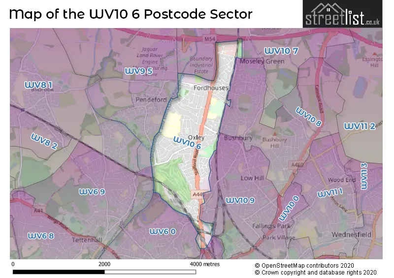
The WV10 6 postcode sector stands on the West Midlands and Staffordshire border.
Did you know? According to the 2021 Census, the WV10 6 postcode sector is home to a bustling 14,256 residents!
Given that each sector allows for 400 unique postcode combinations. Letters C, I, K, M, O and V are not allowed in the last two letters of a postcode. With 265 postcodes already in use, this leaves 135 units available.
The largest settlements in the WV10 6 postal code are WOLVERHAMPTON and Oxley.
The WV10 6 Postcode shares a border with WV1 1 (WOLVERHAMPTON), WV1 4 (WOLVERHAMPTON), WV6 0 (WOLVERHAMPTON), WV6 9 (WOLVERHAMPTON, Tettenhall), WV9 5 (WOLVERHAMPTON, Coven, Pendeford), WV10 7 (Featherstone, Shareshill, Four Ashes), WV10 8 (WOLVERHAMPTON, Wednesfield, Westcroft) and WV10 9 (WOLVERHAMPTON).
The sector is within the post town of WOLVERHAMPTON.
WV10 6 is a postcode sector within the WV10 postcode district which is within the WV Wolverhampton postcode area.
The Royal Mail delivery office for the WV10 6 postal sector is the Wolverhampton Delivery Office.
The area of the WV10 6 postcode sector is 1.61 square miles which is 4.18 square kilometres or 1,032.89 square acres.
The WV10 6 postcode sector is crossed by the M54 motorway.
The WV10 6 postcode sector is crossed by the A449 Major A road.
Waterways within the WV10 6 postcode sector include the Birmingham Canal Navigations, Staffordshire and Worcestershire Canal, Shropshire Union Canal.

Map of the WV10 6 Postcode Sector
Explore the WV10 6 postcode sector by using our free interactive map.
| W | V | 1 | 0 | - | 6 | X | X |
| W | V | 1 | 0 | Space | 6 | Letter | Letter |
Official List of Streets
WOLVERHAMPTON (138 Streets)
Fordhouses (2 Streets)
Oxley (2 Streets)
Unofficial Streets or Alternative Spellings
Coven Heath
STAFFORD ROAD AETHELRED COURT ALDERSLEY JUNCTION BRIDGE BRABOURNE AVENUE COXWELL AVENUE DUNSTALL PARK BRIDGE FORDHOUSES ROUNDABOUT LOCK TAIL BRIDGE MAMMOTH DRIVE MARSH LANE PARADE SAINT ANNES ROAD SHORT CUT TO CANAL THREE TUNS ISLAND THREE TUNS PARADE VINE ISLANDWOLVERHAMPTON
AINSWORTH ROAD BLAYDON ROAD ELSTON HALL LANE FAIRFAX ROAD PRIMROSE AVENUE VIADUCT DRIVE WOOD LANEPendeford
WOBASTON ROADWeather Forecast for WV10 6
Press Button to Show Forecast for Oxley
| Time Period | Icon | Description | Temperature | Rain Probability | Wind |
|---|---|---|---|---|---|
| 00:00 to 03:00 | Cloudy | 6.0°C (feels like 4.0°C) | 4.00% | NE 4 mph | |
| 03:00 to 06:00 | Clear night | 3.0°C (feels like 2.0°C) | 0.00% | NNW 4 mph | |
| 06:00 to 09:00 | Sunny day | 4.0°C (feels like 2.0°C) | 0.00% | NNW 4 mph | |
| 09:00 to 12:00 | Partly cloudy (day) | 7.0°C (feels like 6.0°C) | 0.00% | N 7 mph | |
| 12:00 to 15:00 | Cloudy | 10.0°C (feels like 8.0°C) | 4.00% | N 9 mph | |
| 15:00 to 18:00 | Cloudy | 11.0°C (feels like 9.0°C) | 6.00% | N 9 mph | |
| 18:00 to 21:00 | Cloudy | 10.0°C (feels like 9.0°C) | 5.00% | N 7 mph | |
| 21:00 to 00:00 | Cloudy | 8.0°C (feels like 6.0°C) | 4.00% | NNE 4 mph |
Press Button to Show Forecast for Oxley
| Time Period | Icon | Description | Temperature | Rain Probability | Wind |
|---|---|---|---|---|---|
| 00:00 to 03:00 | Partly cloudy (night) | 5.0°C (feels like 4.0°C) | 0.00% | NNE 4 mph | |
| 03:00 to 06:00 | Cloudy | 5.0°C (feels like 4.0°C) | 5.00% | ENE 2 mph | |
| 06:00 to 09:00 | Overcast | 6.0°C (feels like 4.0°C) | 9.00% | NNE 4 mph | |
| 09:00 to 12:00 | Overcast | 7.0°C (feels like 5.0°C) | 14.00% | NE 7 mph | |
| 12:00 to 15:00 | Overcast | 9.0°C (feels like 7.0°C) | 10.00% | NE 7 mph | |
| 15:00 to 18:00 | Overcast | 10.0°C (feels like 8.0°C) | 11.00% | NE 9 mph | |
| 18:00 to 21:00 | Cloudy | 9.0°C (feels like 8.0°C) | 7.00% | NE 7 mph | |
| 21:00 to 00:00 | Cloudy | 6.0°C (feels like 4.0°C) | 6.00% | NE 4 mph |
Press Button to Show Forecast for Oxley
| Time Period | Icon | Description | Temperature | Rain Probability | Wind |
|---|---|---|---|---|---|
| 00:00 to 03:00 | Cloudy | 4.0°C (feels like 3.0°C) | 6.00% | ENE 4 mph | |
| 03:00 to 06:00 | Overcast | 5.0°C (feels like 3.0°C) | 10.00% | ESE 2 mph | |
| 06:00 to 09:00 | Overcast | 5.0°C (feels like 4.0°C) | 15.00% | SSE 2 mph | |
| 09:00 to 12:00 | Cloudy | 7.0°C (feels like 6.0°C) | 15.00% | S 4 mph | |
| 12:00 to 15:00 | Light rain | 10.0°C (feels like 8.0°C) | 46.00% | SW 7 mph | |
| 15:00 to 18:00 | Light rain | 11.0°C (feels like 9.0°C) | 44.00% | ENE 9 mph | |
| 18:00 to 21:00 | Overcast | 10.0°C (feels like 8.0°C) | 20.00% | NE 9 mph | |
| 21:00 to 00:00 | Overcast | 9.0°C (feels like 7.0°C) | 16.00% | NE 7 mph |
Press Button to Show Forecast for Oxley
| Time Period | Icon | Description | Temperature | Rain Probability | Wind |
|---|---|---|---|---|---|
| 00:00 to 03:00 | Cloudy | 8.0°C (feels like 6.0°C) | 10.00% | NNE 7 mph | |
| 03:00 to 06:00 | Overcast | 7.0°C (feels like 5.0°C) | 10.00% | NE 7 mph | |
| 06:00 to 09:00 | Cloudy | 6.0°C (feels like 3.0°C) | 6.00% | NNE 7 mph | |
| 09:00 to 12:00 | Overcast | 8.0°C (feels like 6.0°C) | 9.00% | NE 9 mph | |
| 12:00 to 15:00 | Overcast | 10.0°C (feels like 8.0°C) | 13.00% | NNE 9 mph | |
| 15:00 to 18:00 | Cloudy | 11.0°C (feels like 9.0°C) | 9.00% | NNE 9 mph | |
| 18:00 to 21:00 | Cloudy | 10.0°C (feels like 9.0°C) | 8.00% | NNE 9 mph | |
| 21:00 to 00:00 | Cloudy | 8.0°C (feels like 7.0°C) | 6.00% | NE 4 mph |
Schools and Places of Education Within the WV10 6 Postcode Sector
Ormiston NEW Academy
Academy sponsor led
Marsh Lane, Wolverhampton, West Midlands, WV10 6SE
Head: Mr Craig Cooling
Ofsted Rating: Good
Inspection: 2022-02-16 (794 days ago)
Website: Visit Ormiston NEW Academy Website
Phone:
Number of Pupils: 867
Rakegate Primary School
Community school
Rakegate Close, Wolverhampton, West Midlands, WV10 6US
Head: Mrs Sarah Horton
Ofsted Rating: Good
Inspection: 2023-06-07 (318 days ago)
Website: Visit Rakegate Primary School Website
Phone: 01902558608
Number of Pupils: 462
St Anthony's Catholic Primary Academy
Academy converter
Stafford Road, Wolverhampton, West Midlands, WV10 6NW
Head: Mrs T Davis
Ofsted Rating: Good
Inspection: 2023-07-04 (291 days ago)
Website: Visit St Anthony's Catholic Primary Academy Website
Phone: 01902558935
Number of Pupils: 346
House Prices in the WV10 6 Postcode Sector
| Type of Property | 2018 Average | 2018 Sales | 2017 Average | 2017 Sales | 2016 Average | 2016 Sales | 2015 Average | 2015 Sales |
|---|---|---|---|---|---|---|---|---|
| Detached | £223,633 | 74 | £212,632 | 73 | £208,247 | 63 | £186,163 | 38 |
| Semi-Detached | £154,566 | 159 | £147,440 | 163 | £136,480 | 149 | £124,817 | 110 |
| Terraced | £136,248 | 65 | £121,845 | 77 | £136,215 | 64 | £113,186 | 28 |
| Flats | £93,471 | 17 | £86,708 | 12 | £92,757 | 15 | £94,456 | 32 |
Important Postcodes WV10 6 in the Postcode Sector
WV10 6HU is the postcode for Aethelred Court, Leverton Rise
WV10 6NN is the postcode for Elston Hall Primary School, Stafford Road
WV10 6NW is the postcode for St. Anthonys Catholic Primary School, Stafford Road, St Anthony's Catholic Primary Academy, Stafford Road, ST ANTHONYS ROMAN CATHOLIC PRIMARY SCHOOL, STAFFORD ROAD, and ST ANTHONYS ROMAN CATHOLIC PRIMARY SCHOOL, STAFFORD ROAD, WOLVERHAMPTON
WV10 6RU is the postcode for 68 Marsh Lane
WV10 6SE is the postcode for SIXTH FORM CENTRE, North East Wolverhampton Academy, Marsh Lane, EXCELLENCE BUILDING, North East Wolverhampton Academy, Marsh Lane, Pendeford Business & Enterprise College, Oak House, Marsh Lane, and ENDEAVOUR BUILDING, North East Wolverhampton Academy, Marsh Lane
WV10 6SJ is the postcode for Rakegate Primary School, Sandwell Road
WV10 6UF is the postcode for Oxley Medical Centre, Probert Road, Oxley Day Centre, Probert Road, and Probert Court, Probert Road
WV10 6US is the postcode for Rakegate Primary School, Rakegate Close
| The WV10 6 Sector is within these Local Authorities |
|
|---|---|
| The WV10 6 Sector is within these Counties |
|
| The WV10 6 Sector is within these Water Company Areas |
|