The WV10 9 postcode sector is within the county of West Midlands.
Did you know? According to the 2021 Census, the WV10 9 postcode sector is home to a bustling 14,687 residents!
Given that each sector allows for 400 unique postcode combinations. Letters C, I, K, M, O and V are not allowed in the last two letters of a postcode. With 261 postcodes already in use, this leaves 139 units available.
The WV10 9 postal code covers the settlement of WOLVERHAMPTON.
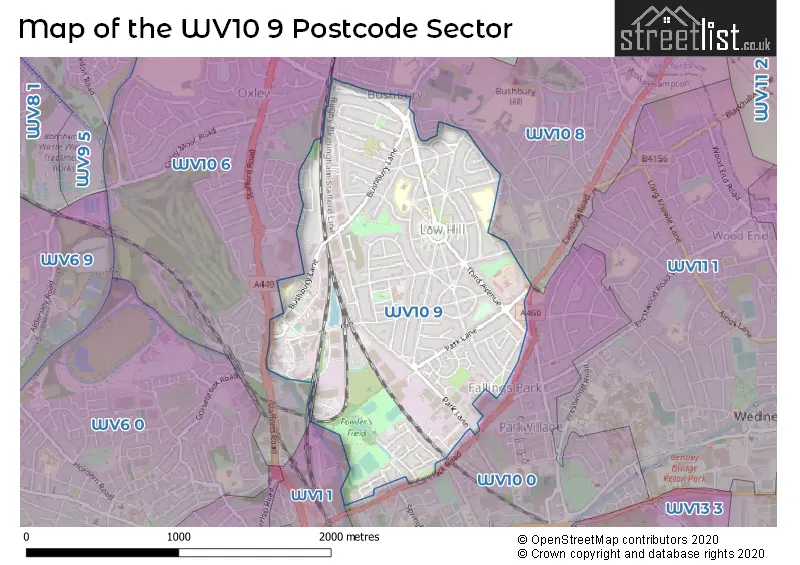
The WV10 9 Postcode shares a border with WV1 1 (WOLVERHAMPTON), WV10 0 (WOLVERHAMPTON, Heath Town), WV10 6 (WOLVERHAMPTON, Oxley) and WV10 8 (WOLVERHAMPTON, Wednesfield, Westcroft).
The sector is within the post town of WOLVERHAMPTON.
WV10 9 is a postcode sector within the WV10 postcode district which is within the WV Wolverhampton postcode area.
The Royal Mail delivery office for the WV10 9 postal sector is the Wolverhampton Delivery Office.
The area of the WV10 9 postcode sector is 1.20 square miles which is 3.10 square kilometres or 765.40 square acres.
Waterways within the WV10 9 postcode sector include the Birmingham Canal Navigations.

Map of the WV10 9 Postcode Sector
Explore the WV10 9 postcode sector by using our free interactive map.
| W | V | 1 | 0 | - | 9 | X | X |
| W | V | 1 | 0 | Space | 9 | Letter | Letter |
Official List of Streets
WOLVERHAMPTON (103 Streets)
Park Village (2 Streets)
Bushbury (3 Streets)
Unofficial Streets or Alternative Spellings
WOLVERHAMPTON
CADWELL CRESCENT CHARTWELL DRIVE CROFT GARDENS DAYTONA GROVE GOODWOOD DRIVE INDIANAPOLIS GARDENS KNOCKHILL GARDENS MALLORY ROAD OLD FALLINGS LANE OULTON DRIVE RANGER DRIVE SILVERSTONE DRIVE SNETTERTON GARDENS THREE TUNS LANE THRUXTON AVENUE WOLSELEY GATE WOOD LANEFallings Park
CANNOCK ROADCoven Heath
STAFFORD ROAD BROOKLANDS CLOSE CHALLENGE WAY COXWELL AVENUE DICKENSON AVENUE GLAISHER DRIVE HAWSKFORD CRESCENT MALVERN COURT MAMMOTH DRIVE ROCKINGHAM CLOSE SHORT ROAD WRIGHT STREETWeather Forecast for WV10 9
Press Button to Show Forecast for Bushbury
| Time Period | Icon | Description | Temperature | Rain Probability | Wind |
|---|---|---|---|---|---|
| 09:00 to 12:00 | Cloudy | 7.0°C (feels like 4.0°C) | 11.00% | WNW 9 mph | |
| 12:00 to 15:00 | Cloudy | 8.0°C (feels like 6.0°C) | 33.00% | NW 9 mph | |
| 15:00 to 18:00 | Light rain | 8.0°C (feels like 6.0°C) | 43.00% | NNE 9 mph | |
| 18:00 to 21:00 | Cloudy | 7.0°C (feels like 6.0°C) | 6.00% | ENE 7 mph | |
| 21:00 to 00:00 | Cloudy | 6.0°C (feels like 5.0°C) | 7.00% | NE 4 mph |
Press Button to Show Forecast for Bushbury
| Time Period | Icon | Description | Temperature | Rain Probability | Wind |
|---|---|---|---|---|---|
| 00:00 to 03:00 | Cloudy | 5.0°C (feels like 3.0°C) | 6.00% | ENE 4 mph | |
| 03:00 to 06:00 | Cloudy | 3.0°C (feels like 1.0°C) | 4.00% | ENE 4 mph | |
| 06:00 to 09:00 | Cloudy | 3.0°C (feels like 1.0°C) | 4.00% | ENE 7 mph | |
| 09:00 to 12:00 | Cloudy | 6.0°C (feels like 4.0°C) | 6.00% | ENE 7 mph | |
| 12:00 to 15:00 | Overcast | 8.0°C (feels like 7.0°C) | 9.00% | ENE 4 mph | |
| 15:00 to 18:00 | Overcast | 9.0°C (feels like 8.0°C) | 12.00% | ENE 4 mph | |
| 18:00 to 21:00 | Cloudy | 9.0°C (feels like 7.0°C) | 10.00% | ENE 4 mph | |
| 21:00 to 00:00 | Partly cloudy (night) | 5.0°C (feels like 3.0°C) | 8.00% | E 7 mph |
Press Button to Show Forecast for Bushbury
| Time Period | Icon | Description | Temperature | Rain Probability | Wind |
|---|---|---|---|---|---|
| 00:00 to 03:00 | Partly cloudy (night) | 4.0°C (feels like 1.0°C) | 8.00% | ENE 7 mph | |
| 03:00 to 06:00 | Cloudy | 3.0°C (feels like 0.0°C) | 11.00% | ENE 7 mph | |
| 06:00 to 09:00 | Cloudy | 3.0°C (feels like 0.0°C) | 11.00% | ENE 7 mph | |
| 09:00 to 12:00 | Overcast | 7.0°C (feels like 4.0°C) | 17.00% | ENE 9 mph | |
| 12:00 to 15:00 | Overcast | 9.0°C (feels like 6.0°C) | 21.00% | ENE 9 mph | |
| 15:00 to 18:00 | Overcast | 10.0°C (feels like 8.0°C) | 23.00% | ENE 9 mph | |
| 18:00 to 21:00 | Cloudy | 9.0°C (feels like 7.0°C) | 18.00% | ENE 9 mph | |
| 21:00 to 00:00 | Cloudy | 7.0°C (feels like 4.0°C) | 20.00% | NE 11 mph |
Press Button to Show Forecast for Bushbury
| Time Period | Icon | Description | Temperature | Rain Probability | Wind |
|---|---|---|---|---|---|
| 00:00 to 03:00 | Overcast | 6.0°C (feels like 3.0°C) | 19.00% | NE 11 mph | |
| 03:00 to 06:00 | Light rain | 6.0°C (feels like 3.0°C) | 53.00% | NE 11 mph | |
| 06:00 to 09:00 | Heavy rain | 6.0°C (feels like 3.0°C) | 75.00% | NNE 11 mph | |
| 09:00 to 12:00 | Heavy rain | 7.0°C (feels like 4.0°C) | 77.00% | N 11 mph | |
| 12:00 to 15:00 | Light rain | 9.0°C (feels like 6.0°C) | 55.00% | N 11 mph | |
| 15:00 to 18:00 | Light rain | 9.0°C (feels like 7.0°C) | 53.00% | NNE 11 mph | |
| 18:00 to 21:00 | Light rain shower (day) | 9.0°C (feels like 7.0°C) | 41.00% | N 9 mph | |
| 21:00 to 00:00 | Partly cloudy (night) | 7.0°C (feels like 5.0°C) | 11.00% | NNE 7 mph |
Schools and Places of Education Within the WV10 9 Postcode Sector
Bushbury Lane Academy
Academy sponsor led
Ripon Road, Wolverhampton, West Midlands, WV10 9TR
Head: Miss Lisa Smith
Ofsted Rating: Requires improvement
Inspection: 2020-02-05 (1541 days ago)
Website: Visit Bushbury Lane Academy Website
Phone: 01902556486
Number of Pupils: 227
Low Hill Nursery School
Local authority nursery school
Jenks Avenue, Wolverhampton, West Midlands, WV10 9JN
Head: Mrs Natalie Showell
Ofsted Rating: Outstanding
Inspection: 2023-07-04 (296 days ago)
Website: Visit Low Hill Nursery School Website
Phone: 01902558124
Number of Pupils: 141
Whitgreave Primary School
Community school
Goodyear Avenue, Wolverhampton, West Midlands, WV10 9JP
Head: Mrs Sarah Redfern
Ofsted Rating: Outstanding
Inspection: 2023-01-26 (455 days ago)
Website: Visit Whitgreave Primary School Website
Phone: 01902558930
Number of Pupils: 462
House Prices in the WV10 9 Postcode Sector
| Type of Property | 2018 Average | 2018 Sales | 2017 Average | 2017 Sales | 2016 Average | 2016 Sales | 2015 Average | 2015 Sales |
|---|---|---|---|---|---|---|---|---|
| Detached | £160,000 | 1 | £185,600 | 5 | £135,000 | 1 | £109,500 | 6 |
| Semi-Detached | £120,658 | 65 | £111,023 | 48 | £92,551 | 62 | £89,283 | 67 |
| Terraced | £97,187 | 32 | £94,128 | 39 | £74,272 | 45 | £77,280 | 40 |
| Flats | £98,167 | 3 | £67,025 | 5 | £44,000 | 3 | £67,188 | 4 |
Important Postcodes WV10 9 in the Postcode Sector
WV10 9AW is the postcode for PLAYING FIELDS CHANGING ROOM, Fowlers Park, Nine Elms Lane
WV10 9HS is the postcode for Whitgreave Infant School, Low Hill Crescent
WV10 9JL is the postcode for Low Hill Social Services, 16 Showell Circus, and Wolverhampton City Council, Low Hill Library, Showell Circus
WV10 9JN is the postcode for Low Hill Nursery School, Jenks Avenue
WV10 9JP is the postcode for Whitgreave Junior School, Goodyear Avenue
WV10 9LZ is the postcode for Low Hill Strengthening Families Hub, Fourth Avenue
WV10 9NN is the postcode for Showell Court, Othello Road
WV10 9PG is the postcode for Poplars Medical Practice, The Poplars, Third Avenue
WV10 9ST is the postcode for Showell Park EAPC, Fifth Avenue
WV10 9SX is the postcode for Low Hill Medical Centre, 191 First Avenue
WV10 9TH is the postcode for Steps to Health, Low Hill Community Health Centre, Showell Circus
WV10 9TR is the postcode for Bushbury Lane Academy, Ripon Road
| The WV10 9 Sector is within these Local Authorities |
|
|---|---|
| The WV10 9 Sector is within these Counties |
|
| The WV10 9 Sector is within these Water Company Areas |
|