The WV4 5 postcode sector stands on the Staffordshire and West Midlands border.
Did you know? According to the 2021 Census, the WV4 5 postcode sector is home to a bustling 10,865 residents!
Given that each sector allows for 400 unique postcode combinations. Letters C, I, K, M, O and V are not allowed in the last two letters of a postcode. With 252 postcodes already in use, this leaves 148 units available.
The largest settlement in the WV4 5 postal code is WOLVERHAMPTON followed by Penn, and Goldthorn Park.
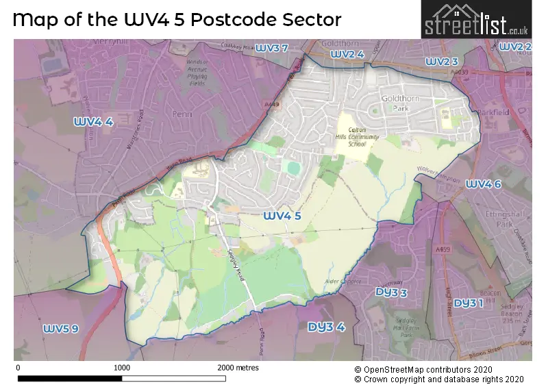
The WV4 5 Postcode shares a border with WV3 0 (WOLVERHAMPTON), WV2 3 (WOLVERHAMPTON, Blakenhall), WV3 7 (WOLVERHAMPTON, Bradmore, Penn Fields), WV4 4 (WOLVERHAMPTON, Penn), WV4 6 (WOLVERHAMPTON, Lanesfield, Ettingshall), DY3 3 (DUDLEY, Sedgley), DY3 4 (Swindon, DUDLEY, Himley), WV5 9 (Wombourne) and WV2 4 (WOLVERHAMPTON).
The sector is within the post town of WOLVERHAMPTON.
WV4 5 is a postcode sector within the WV4 postcode district which is within the WV Wolverhampton postcode area.
The Royal Mail delivery office for the WV4 5 postal sector is the Wolverhampton Delivery Office.
The area of the WV4 5 postcode sector is 2.21 square miles which is 5.73 square kilometres or 1,414.84 square acres.
Waterways within the WV4 5 postcode sector include the Wom Brook.

Map of the WV4 5 Postcode Sector
Explore the WV4 5 postcode sector by using our free interactive map.
| W | V | 4 | - | 5 | X | X |
| W | V | 4 | Space | 5 | Letter | Letter |
Official List of Streets
WOLVERHAMPTON (102 Streets)
Penn (11 Streets)
Goldthorn Park (2 Streets)
Unofficial Streets or Alternative Spellings
WOLVERHAMPTON
COALWAY AVENUE DEBORAH CLOSE GOLDTHORN HILL HOLLYBUSH LANE SHOWELL LANE SPRINGHILL LANE UPPER VILLIERS STREET WOLVERHAMPTON ROAD EASTParkfields
LAWNSWOOD AVENUE GOLTHORN CRESCENT GREATHALL GROVE LEE MANOR DRIVE PENWOOD LANE ROSEMARY AVE RYCROFT AVENUE SAINT CATHERINES CRESCENT THIRLSTONE DRIVE TURF COTTAGES WITTON RD WYTHMERE LANEDUDLEY
PENN ROADWombourne
STOURBRIDGE ROADWeather Forecast for WV4 5
Press Button to Show Forecast for Spring Hill
| Time Period | Icon | Description | Temperature | Rain Probability | Wind |
|---|---|---|---|---|---|
| 09:00 to 12:00 | Cloudy | 7.0°C (feels like 5.0°C) | 11.00% | WNW 9 mph | |
| 12:00 to 15:00 | Cloudy | 9.0°C (feels like 6.0°C) | 5.00% | NW 9 mph | |
| 15:00 to 18:00 | Light rain | 8.0°C (feels like 6.0°C) | 50.00% | NNE 9 mph | |
| 18:00 to 21:00 | Cloudy | 7.0°C (feels like 6.0°C) | 8.00% | NE 7 mph | |
| 21:00 to 00:00 | Cloudy | 6.0°C (feels like 5.0°C) | 6.00% | NE 4 mph |
Press Button to Show Forecast for Spring Hill
| Time Period | Icon | Description | Temperature | Rain Probability | Wind |
|---|---|---|---|---|---|
| 00:00 to 03:00 | Cloudy | 5.0°C (feels like 3.0°C) | 7.00% | ENE 4 mph | |
| 03:00 to 06:00 | Cloudy | 4.0°C (feels like 2.0°C) | 6.00% | ENE 4 mph | |
| 06:00 to 09:00 | Cloudy | 3.0°C (feels like 1.0°C) | 4.00% | E 4 mph | |
| 09:00 to 12:00 | Cloudy | 6.0°C (feels like 4.0°C) | 6.00% | ENE 7 mph | |
| 12:00 to 15:00 | Overcast | 8.0°C (feels like 7.0°C) | 9.00% | ENE 4 mph | |
| 15:00 to 18:00 | Cloudy | 9.0°C (feels like 8.0°C) | 9.00% | ENE 4 mph | |
| 18:00 to 21:00 | Cloudy | 9.0°C (feels like 8.0°C) | 10.00% | ENE 4 mph | |
| 21:00 to 00:00 | Partly cloudy (night) | 6.0°C (feels like 3.0°C) | 8.00% | ENE 7 mph |
Press Button to Show Forecast for Spring Hill
| Time Period | Icon | Description | Temperature | Rain Probability | Wind |
|---|---|---|---|---|---|
| 00:00 to 03:00 | Partly cloudy (night) | 4.0°C (feels like 1.0°C) | 8.00% | ENE 7 mph | |
| 03:00 to 06:00 | Cloudy | 3.0°C (feels like 1.0°C) | 12.00% | NE 4 mph | |
| 06:00 to 09:00 | Cloudy | 3.0°C (feels like 1.0°C) | 10.00% | NE 7 mph | |
| 09:00 to 12:00 | Cloudy | 7.0°C (feels like 4.0°C) | 15.00% | ENE 9 mph | |
| 12:00 to 15:00 | Overcast | 9.0°C (feels like 7.0°C) | 21.00% | ENE 9 mph | |
| 15:00 to 18:00 | Overcast | 10.0°C (feels like 8.0°C) | 23.00% | ENE 9 mph | |
| 18:00 to 21:00 | Overcast | 9.0°C (feels like 7.0°C) | 20.00% | ENE 9 mph | |
| 21:00 to 00:00 | Cloudy | 7.0°C (feels like 4.0°C) | 20.00% | NE 11 mph |
Press Button to Show Forecast for Spring Hill
| Time Period | Icon | Description | Temperature | Rain Probability | Wind |
|---|---|---|---|---|---|
| 00:00 to 03:00 | Cloudy | 6.0°C (feels like 3.0°C) | 19.00% | NE 11 mph | |
| 03:00 to 06:00 | Cloudy | 6.0°C (feels like 3.0°C) | 25.00% | NNE 11 mph | |
| 06:00 to 09:00 | Heavy rain | 6.0°C (feels like 3.0°C) | 75.00% | NNE 11 mph | |
| 09:00 to 12:00 | Heavy rain | 7.0°C (feels like 4.0°C) | 77.00% | NNE 11 mph | |
| 12:00 to 15:00 | Light rain | 9.0°C (feels like 5.0°C) | 53.00% | N 13 mph | |
| 15:00 to 18:00 | Light rain | 9.0°C (feels like 7.0°C) | 54.00% | NNE 11 mph | |
| 18:00 to 21:00 | Light rain shower (day) | 9.0°C (feels like 7.0°C) | 39.00% | N 9 mph | |
| 21:00 to 00:00 | Clear night | 7.0°C (feels like 5.0°C) | 11.00% | N 7 mph |
Schools and Places of Education Within the WV4 5 Postcode Sector
Colton Hills Community School
Community school
Jeremy Road, Wolverhampton, West Midlands, WV4 5DG
Head: Ms Julie Hunter
Ofsted Rating: Good
Inspection: 2023-11-15 (162 days ago)
Website: Visit Colton Hills Community School Website
Phone: 01902558420
Number of Pupils: 1021
Goldthorn Park Primary School
Academy converter
Ward Road, Wolverhampton, West Midlands, WV4 5ET
Head: Mrs Rachel Purshouse
Ofsted Rating: Good
Inspection: 2022-03-02 (785 days ago)
Website: Visit Goldthorn Park Primary School Website
Phone: 01902558730
Number of Pupils: 434
House Prices in the WV4 5 Postcode Sector
| Type of Property | 2018 Average | 2018 Sales | 2017 Average | 2017 Sales | 2016 Average | 2016 Sales | 2015 Average | 2015 Sales |
|---|---|---|---|---|---|---|---|---|
| Detached | £286,723 | 42 | £257,392 | 66 | £262,321 | 74 | £219,793 | 64 |
| Semi-Detached | £192,907 | 49 | £186,248 | 62 | £173,651 | 68 | £165,713 | 52 |
| Terraced | £178,954 | 27 | £145,452 | 29 | £154,194 | 20 | £158,445 | 19 |
| Flats | £136,783 | 12 | £167,552 | 24 | £161,863 | 50 | £111,417 | 6 |
Important Postcodes WV4 5 in the Postcode Sector
WV4 5DG is the postcode for Colton Hills Community School, Jeremy Road, MAIN BUILDING, Colton Hills Community School, Jeremy Road, and DANCE STUDIO, Colton Hills Community School, Jeremy Road
WV4 5ET is the postcode for GOLDTHORN PARK (JUNIORS) PRIMARY SCHOOL, Goldthorn Park Primary School, Ward Road, INFANT BUILDING, Goldthorn Park Primary School, Ward Road, JUNIOR BUILDING, Goldthorn Park Primary School, Ward Road, and GOLDTHORN PARK (INFANTS) PRIMARY SCHOOL, Goldthorn Park Primary School, Ward Road
WV4 5HN is the postcode for JUNIPER, Penn Hospital, Penn Road, ELDERLY MENTAL HEALTH PENN HOSPITAL, Wolverhampton City PCT, Penn Hospital, MAIN BUILDING, Penn Hospital, Penn Road, JASMINE, Penn Hospital, Penn Road, ADULT MENTAL HEALTH PENN HOSPITAL, Wolverhampton City PCT, Penn Hospital, and Wolverhampton City PCT, Penn Hospital
WV4 5HP is the postcode for MAIN BUILDING, Penn Hall School, Vicarage Road, DAY CENTRE, Penn Hall School, Vicarage Road, and Penn Hall School, Vicarage Road
WV4 5LG is the postcode for KS1 BUILDING, St. Bartholomews School, Sedgley Road, and KS2 BUILDING, St. Bartholomews School, Sedgley Road
WV4 5PY is the postcode for Penn Manor Medical Centre, Manor Road
| The WV4 5 Sector is within these Local Authorities |
|
|---|---|
| The WV4 5 Sector is within these Counties |
|
| The WV4 5 Sector is within these Water Company Areas |
|