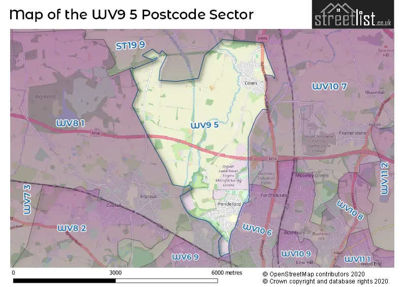
The WV9 5 postcode sector stands on the Staffordshire and West Midlands border.
Did you know? According to the 2021 Census, the WV9 5 postcode sector is home to a bustling 6,834 residents!
Given that each sector allows for 400 unique postcode combinations. Letters C, I, K, M, O and V are not allowed in the last two letters of a postcode. With 185 postcodes already in use, this leaves 215 units available.
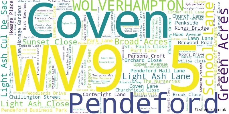
The largest settlement in the WV9 5 postal code is WOLVERHAMPTON followed by Coven, and Pendeford.
The WV9 5 Postcode shares a border with ST19 9 (Brewood, Wheaton Aston, Bishops Wood), WV6 9 (WOLVERHAMPTON, Tettenhall), WV10 6 (WOLVERHAMPTON, Oxley), WV10 7 (Featherstone, Shareshill, Four Ashes) and WV8 1 (Codsall, WOLVERHAMPTON, Pendeford).
The sector is within the post town of WOLVERHAMPTON.
WV9 5 is a postcode sector within the WV9 postcode district which is within the WV Wolverhampton postcode area.
The Royal Mail delivery office for the WV9 5 postal sector is the Wolverhampton Delivery Office.
The area of the WV9 5 postcode sector is 5.57 square miles which is 14.42 square kilometres or 3,563.70 square acres.
The WV9 5 postcode sector is crossed by the M54 motorway.
The WV9 5 postcode sector is crossed by the A449 Major A road.
Waterways within the WV9 5 postcode sector include the Staffordshire and Worcestershire Canal, Shropshire Union Canal, River Penk, Penk.

Map of the WV9 5 Postcode Sector
Explore the WV9 5 postcode sector by using our free interactive map.
| W | V | 9 | - | 5 | X | X |
| W | V | 9 | Space | 5 | Letter | Letter |
Official List of Streets
WOLVERHAMPTON (59 Streets)
Pendeford (19 Streets)
Coven (54 Streets)
Unofficial Streets or Alternative Spellings
Coven Heath
STAFFORD ROADCross Green
OLD STAFFORD ROAD BALLIOL ROAD BARLEY FIELD CELADINE DRIVE CELEDINE DRIVE COW LANE CRESWELL COURT ELMSWORTH CRESCENT LIGHT ASH LOWER AVENUE OVERSTRAND PENKSIDE WALK SHAWHALL LANE SIDESTRAND WATER SIDE WAY WILLOW WOBASTON ROAD ROUNDABOUTCodsall
BARNHURST LANEBrewood
COVEN ROAD PARK LANECodsall Wood
CHILLINGTON STREETWeather Forecast for WV9 5
Press Button to Show Forecast for Codsall
| Time Period | Icon | Description | Temperature | Rain Probability | Wind |
|---|---|---|---|---|---|
| 03:00 to 06:00 | Cloudy | 3.0°C (feels like 0.0°C) | 8.00% | WSW 4 mph | |
| 06:00 to 09:00 | Cloudy | 4.0°C (feels like 2.0°C) | 49.00% | WSW 7 mph | |
| 09:00 to 12:00 | Cloudy | 8.0°C (feels like 5.0°C) | 6.00% | WNW 11 mph | |
| 12:00 to 15:00 | Light rain | 9.0°C (feels like 7.0°C) | 43.00% | NW 9 mph | |
| 15:00 to 18:00 | Light rain shower (day) | 9.0°C (feels like 6.0°C) | 48.00% | NNE 9 mph | |
| 18:00 to 21:00 | Cloudy | 8.0°C (feels like 6.0°C) | 6.00% | NE 4 mph | |
| 21:00 to 00:00 | Cloudy | 6.0°C (feels like 5.0°C) | 4.00% | NE 4 mph |
Press Button to Show Forecast for Codsall
| Time Period | Icon | Description | Temperature | Rain Probability | Wind |
|---|---|---|---|---|---|
| 00:00 to 03:00 | Cloudy | 5.0°C (feels like 2.0°C) | 6.00% | ENE 7 mph | |
| 03:00 to 06:00 | Partly cloudy (night) | 3.0°C (feels like 1.0°C) | 2.00% | ENE 4 mph | |
| 06:00 to 09:00 | Partly cloudy (day) | 3.0°C (feels like 1.0°C) | 2.00% | E 4 mph | |
| 09:00 to 12:00 | Cloudy | 7.0°C (feels like 5.0°C) | 6.00% | ENE 4 mph | |
| 12:00 to 15:00 | Cloudy | 9.0°C (feels like 7.0°C) | 9.00% | ENE 4 mph | |
| 15:00 to 18:00 | Cloudy | 10.0°C (feels like 9.0°C) | 9.00% | ENE 4 mph | |
| 18:00 to 21:00 | Cloudy | 9.0°C (feels like 8.0°C) | 9.00% | ENE 4 mph | |
| 21:00 to 00:00 | Cloudy | 6.0°C (feels like 3.0°C) | 10.00% | E 7 mph |
Press Button to Show Forecast for Codsall
| Time Period | Icon | Description | Temperature | Rain Probability | Wind |
|---|---|---|---|---|---|
| 00:00 to 03:00 | Partly cloudy (night) | 4.0°C (feels like 1.0°C) | 8.00% | ENE 7 mph | |
| 03:00 to 06:00 | Cloudy | 3.0°C (feels like 0.0°C) | 11.00% | ENE 7 mph | |
| 06:00 to 09:00 | Cloudy | 4.0°C (feels like 1.0°C) | 10.00% | ENE 7 mph | |
| 09:00 to 12:00 | Overcast | 7.0°C (feels like 5.0°C) | 18.00% | E 9 mph | |
| 12:00 to 15:00 | Overcast | 9.0°C (feels like 7.0°C) | 21.00% | E 9 mph | |
| 15:00 to 18:00 | Overcast | 10.0°C (feels like 8.0°C) | 23.00% | ENE 9 mph | |
| 18:00 to 21:00 | Cloudy | 10.0°C (feels like 7.0°C) | 18.00% | ENE 9 mph | |
| 21:00 to 00:00 | Cloudy | 7.0°C (feels like 5.0°C) | 19.00% | NE 9 mph |
Press Button to Show Forecast for Codsall
| Time Period | Icon | Description | Temperature | Rain Probability | Wind |
|---|---|---|---|---|---|
| 00:00 to 03:00 | Cloudy | 6.0°C (feels like 3.0°C) | 20.00% | NE 9 mph | |
| 03:00 to 06:00 | Light rain | 6.0°C (feels like 3.0°C) | 53.00% | NNE 9 mph | |
| 06:00 to 09:00 | Heavy rain | 6.0°C (feels like 3.0°C) | 75.00% | NNE 11 mph | |
| 09:00 to 12:00 | Heavy rain | 7.0°C (feels like 4.0°C) | 77.00% | NNE 11 mph | |
| 12:00 to 15:00 | Light rain | 9.0°C (feels like 6.0°C) | 53.00% | N 11 mph | |
| 15:00 to 18:00 | Light rain | 10.0°C (feels like 7.0°C) | 55.00% | NNE 11 mph | |
| 18:00 to 21:00 | Light rain shower (day) | 10.0°C (feels like 8.0°C) | 40.00% | N 9 mph | |
| 21:00 to 00:00 | Partly cloudy (night) | 7.0°C (feels like 5.0°C) | 11.00% | N 7 mph |
Schools and Places of Education Within the WV9 5 Postcode Sector
St Paul's Church of England Aided Primary School
Voluntary aided school
Emsworth Crescent, Wolverhampton, West Midlands, WV9 5NR
Head: Mrs Jennifer Ferretti
Ofsted Rating: Requires improvement
Inspection: 2022-09-28 (575 days ago)
Website: Visit St Paul's Church of England Aided Primary School Website
Phone: 01902558621
Number of Pupils: 236
House Prices in the WV9 5 Postcode Sector
| Type of Property | 2018 Average | 2018 Sales | 2017 Average | 2017 Sales | 2016 Average | 2016 Sales | 2015 Average | 2015 Sales |
|---|---|---|---|---|---|---|---|---|
| Detached | £229,625 | 20 | £237,635 | 37 | £241,128 | 39 | £207,531 | 24 |
| Semi-Detached | £177,822 | 30 | £157,258 | 38 | £144,339 | 53 | £154,772 | 46 |
| Terraced | £172,824 | 6 | £136,545 | 11 | £118,029 | 14 | £116,000 | 11 |
| Flats | £71,300 | 5 | £78,896 | 13 | £78,052 | 13 | £77,800 | 5 |
Important Postcodes WV9 5 in the Postcode Sector
WV9 5AD is the postcode for ST PAULS CHURCH OF ENGLAND FIRST SCHOOL, SCHOOL LANE, and St. Pauls C of E First School, School Lane
WV9 5NJ is the postcode for Nelson Mandela House, Whitburn Close, Priory Green Primary School, Whitburn Close, Pendeford Health Centre, Whitburn Close, and Wolverhampton City Council, Whitburn Close
WV9 5NR is the postcode for St Paul's CE Primary School, Emsworth Crescent, and St. Pauls C of E Primary School, Emsworth Crescent
| The WV9 5 Sector is within these Local Authorities |
|
|---|---|
| The WV9 5 Sector is within these Counties |
|
| The WV9 5 Sector is within these Water Company Areas |
|