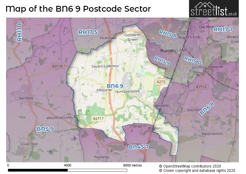
The BN6 9 postcode sector stands on the West Sussex and East Sussex border.
Did you know? According to the 2021 Census, the BN6 9 postcode sector is home to a bustling 9,805 residents!
Given that each sector allows for 400 unique postcode combinations. Letters C, I, K, M, O and V are not allowed in the last two letters of a postcode. With 307 postcodes already in use, this leaves 93 units available.
The largest settlement in the BN6 9 postal code is Hurstpierpoint followed by Sayers Common, and HASSOCKS.
The BN6 9 Postcode shares a border with RH15 8 (BURGESS HILL), BN45 7 (Pyecombe, Poynings, Saddlescombe), RH15 0 (BURGESS HILL), RH15 9 (BURGESS HILL), RH17 5 (Cuckfield, Bolney, Warninglid), BN5 9 (HENFIELD, Small Dole, Woodmancote) and BN6 8 (HASSOCKS, Ditchling, Streat).
The sector is within the post town of HASSOCKS.
BN6 9 is a postcode sector within the BN6 postcode district which is within the BN Brighton postcode area.
The Royal Mail delivery office for the BN6 9 postal sector is the Hassocks Delivery Office.
The area of the BN6 9 postcode sector is 14.24 square miles which is 36.87 square kilometres or 9,111.14 square acres.
The BN6 9 postcode sector is crossed by the A23 Major A road.

Map of the BN6 9 Postcode Sector
Explore the BN6 9 postcode sector by using our free interactive map.
| B | N | 6 | - | 9 | X | X |
| B | N | 6 | Space | 9 | Letter | Letter |
Official List of Streets
Hurstpierpoint (84 Streets)
Albourne (16 Streets)
HASSOCKS (20 Streets)
Sayers Common (25 Streets)
Clayton (6 Streets)
Newtimber (5 Streets)
Goddards Green (3 Streets)
Unofficial Streets or Alternative Spellings
BURGESS HILL
JANE MURRAY WAY ARUNBECK ATHOLE STREET BARLEYCROFT BARLEYCROFT, THE STREET COLLEGE PLACE DALE HILL DIPLOCKS MEWS HALTON SHAWS HUNTERS MEAD, THE STREET HURSTPIERPOINT COLLEGE LONDON ROAD ROUNDABOUT LYNTON FIELDS CLOSE MALTINGS FARM, PROW MILL RACE NORTHBROOKS NORTHEND LANE NORTHERN ARC AVENUE OAKLANDS PARK OSBORN CLOSE, REEDS LANE PIT ROAD RUCKFORD MILL SUNLEIGH COURT SUNSET LANE THE ACORNS THE ACORNS, OAKHURST THE HAM THE MAPLES THE NOOK, REEDS LANE THE ROWANS TOTT LANE TRUMPKINS WALNUT TREE COTTAGES, LONDON ROAD WOODPECKER CRESCENTBURGESS HILL,
LONDON ROADAnsty
BISHOPSTONE LANE CUCKFIELD ROADBolney
STAIRBRIDGE LANEHASSOCKS
LITTLE COPSE ROAD NEW ROAD SHEPHERDS WALK SOUTH BANK STONEPOUND ROADFulking
CLAPPERS LANEWeather Forecast for BN6 9
Press Button to Show Forecast for Hurstpierpoint
| Time Period | Icon | Description | Temperature | Rain Probability | Wind |
|---|---|---|---|---|---|
| 21:00 to 00:00 | Clear night | 8.0°C (feels like 8.0°C) | 0.00% | SSE 2 mph |
Press Button to Show Forecast for Hurstpierpoint
| Time Period | Icon | Description | Temperature | Rain Probability | Wind |
|---|---|---|---|---|---|
| 00:00 to 03:00 | Clear night | 7.0°C (feels like 6.0°C) | 0.00% | S 2 mph | |
| 03:00 to 06:00 | Clear night | 6.0°C (feels like 5.0°C) | 0.00% | SE 4 mph | |
| 06:00 to 09:00 | Sunny day | 8.0°C (feels like 7.0°C) | 1.00% | E 2 mph | |
| 09:00 to 12:00 | Sunny day | 14.0°C (feels like 13.0°C) | 2.00% | SE 7 mph | |
| 12:00 to 15:00 | Cloudy | 15.0°C (feels like 13.0°C) | 6.00% | SSE 9 mph | |
| 15:00 to 18:00 | Cloudy | 14.0°C (feels like 13.0°C) | 7.00% | SSE 9 mph | |
| 18:00 to 21:00 | Cloudy | 13.0°C (feels like 13.0°C) | 7.00% | SSE 4 mph | |
| 21:00 to 00:00 | Overcast | 11.0°C (feels like 10.0°C) | 23.00% | ESE 4 mph |
Press Button to Show Forecast for Hurstpierpoint
| Time Period | Icon | Description | Temperature | Rain Probability | Wind |
|---|---|---|---|---|---|
| 00:00 to 03:00 | Cloudy | 11.0°C (feels like 10.0°C) | 45.00% | ENE 7 mph | |
| 03:00 to 06:00 | Light rain | 10.0°C (feels like 9.0°C) | 51.00% | ENE 4 mph | |
| 06:00 to 09:00 | Light rain | 11.0°C (feels like 9.0°C) | 54.00% | ENE 7 mph | |
| 09:00 to 12:00 | Light rain | 13.0°C (feels like 12.0°C) | 50.00% | E 7 mph | |
| 12:00 to 15:00 | Light rain shower (day) | 14.0°C (feels like 13.0°C) | 42.00% | S 7 mph | |
| 15:00 to 18:00 | Heavy rain shower (day) | 15.0°C (feels like 14.0°C) | 56.00% | NNW 7 mph | |
| 18:00 to 21:00 | Light rain shower (day) | 14.0°C (feels like 13.0°C) | 38.00% | NW 7 mph | |
| 21:00 to 00:00 | Partly cloudy (night) | 11.0°C (feels like 10.0°C) | 5.00% | WNW 7 mph |
Press Button to Show Forecast for Hurstpierpoint
| Time Period | Icon | Description | Temperature | Rain Probability | Wind |
|---|---|---|---|---|---|
| 00:00 to 03:00 | Partly cloudy (night) | 10.0°C (feels like 9.0°C) | 3.00% | WNW 7 mph | |
| 03:00 to 06:00 | Partly cloudy (night) | 9.0°C (feels like 8.0°C) | 2.00% | WNW 7 mph | |
| 06:00 to 09:00 | Partly cloudy (day) | 10.0°C (feels like 9.0°C) | 1.00% | NNW 7 mph | |
| 09:00 to 12:00 | Partly cloudy (day) | 14.0°C (feels like 13.0°C) | 2.00% | NNE 9 mph | |
| 12:00 to 15:00 | Cloudy | 17.0°C (feels like 16.0°C) | 5.00% | NNE 9 mph | |
| 15:00 to 18:00 | Partly cloudy (day) | 18.0°C (feels like 17.0°C) | 5.00% | NW 7 mph | |
| 18:00 to 21:00 | Partly cloudy (day) | 17.0°C (feels like 16.0°C) | 3.00% | NNW 7 mph | |
| 21:00 to 00:00 | Clear night | 12.0°C (feels like 11.0°C) | 2.00% | NNE 4 mph |
Press Button to Show Forecast for Hurstpierpoint
| Time Period | Icon | Description | Temperature | Rain Probability | Wind |
|---|---|---|---|---|---|
| 00:00 to 03:00 | Clear night | 9.0°C (feels like 9.0°C) | 1.00% | NNE 4 mph | |
| 03:00 to 06:00 | Clear night | 8.0°C (feels like 7.0°C) | 1.00% | N 4 mph | |
| 06:00 to 09:00 | Cloudy | 10.0°C (feels like 9.0°C) | 4.00% | N 4 mph | |
| 09:00 to 12:00 | Cloudy | 14.0°C (feels like 14.0°C) | 4.00% | NNE 4 mph | |
| 12:00 to 15:00 | Cloudy | 17.0°C (feels like 16.0°C) | 4.00% | E 4 mph | |
| 15:00 to 18:00 | Cloudy | 18.0°C (feels like 17.0°C) | 10.00% | SE 7 mph | |
| 18:00 to 21:00 | Cloudy | 17.0°C (feels like 16.0°C) | 4.00% | S 7 mph | |
| 21:00 to 00:00 | Cloudy | 12.0°C (feels like 11.0°C) | 3.00% | S 4 mph |
Schools and Places of Education Within the BN6 9 Postcode Sector
St Lawrence CofE Primary School
Academy converter
Trinity Road, Hassocks, West Sussex, BN6 9UY
Head: Mrs Marianne Brand
Ofsted Rating: Good
Inspection: 2021-11-03 (913 days ago)
Website: Visit St Lawrence CofE Primary School Website
Phone: 01273833229
Number of Pupils: 616
House Prices in the BN6 9 Postcode Sector
| Type of Property | 2018 Average | 2018 Sales | 2017 Average | 2017 Sales | 2016 Average | 2016 Sales | 2015 Average | 2015 Sales |
|---|---|---|---|---|---|---|---|---|
| Detached | £699,750 | 70 | £763,869 | 76 | £619,159 | 64 | £617,235 | 56 |
| Semi-Detached | £437,146 | 40 | £459,924 | 47 | £429,381 | 53 | £435,587 | 54 |
| Terraced | £432,262 | 21 | £381,190 | 21 | £394,482 | 29 | £359,530 | 27 |
| Flats | £213,177 | 11 | £258,536 | 14 | £228,875 | 12 | £213,189 | 9 |
Important Postcodes BN6 9 in the Postcode Sector
BN6 9DH is the postcode for Albourne C of E Primary School, The Street
BN6 9HD is the postcode for West Sussex County Council Pookbourne Lane Depot, Pookbourne Lane
BN6 9SA is the postcode for St. Lawrence C of E Primary School, 10 Cuckfield Road
BN6 9UQ is the postcode for The Health Centre, Trinity Road, and THE HEALTH CENTRE, TRINITY ROAD, HURSTPIERPOINT
BN6 9UY is the postcode for St. Lawrence C of E Primary School, Trinity Road
| The BN6 9 Sector is within these Local Authorities |
|
|---|---|
| The BN6 9 Sector is within these Counties |
|
| The BN6 9 Sector is within these Water Company Areas |
|
Tourist Attractions within the BN6 9 Postcode Area
We found 1 visitor attractions within the BN6 postcode area
| Washbrooks Farm Centre |
|---|
| Farms |
| Farm / Rare Breeds / Farm Animals |
| View Washbrooks Farm Centre on Google Maps |