The CB21 postcode district is a postal district located in the CB Cambridge postcode area with a population of 15,880 residents according to the 2021 England and Wales Census.
The area of the CB21 postcode district is 61.98 square miles which is 160.53 square kilometres or 39,667.17 acres.
Currently, the CB21 district has about 430 postcode units spread across 3 geographic postcode sectors.
Given that each sector allows for 400 unique postcode combinations, the district has a capacity of 1,200 postcodes. With 430 postcodes already in use, this leaves 770 units available.
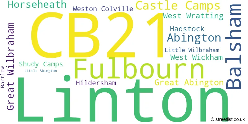
The largest settlement in the CB21 postal code is Linton followed by Fulbourn, and Balsham.
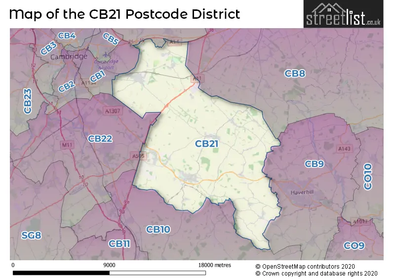
The CB21 Postcode shares a border with CB25 (Burwell, Waterbeach, Bottisham), CB10 (SAFFRON WALDEN, Great Chesterford, Wimbish), CB22 (Sawston, Great Shelford, Duxford), CB9 (HAVERHILL, Kedington, Steeple Bumpstead) and CB1 (CAMBRIDGE, Teversham, Cherry Hinton).
The primary settlement in the CB21 postcode district is Linton, located in the county of Cambridgeshire in England. Other significant settlements in the district include Balsham, Bartlow, Castle Camps, Horseheath, Shudy Camps, West Wickham, Fulbourn, Great Wilbraham, Little Wilbraham, West Wratting, Weston Colville, Abington, Great Abington, Hildersham, and Little Abington. The post town for the CB21 district is Cambridge.
For the district CB21, we have data on 3 postcode sectors. Here's a breakdown: The sector CB21 4, covers Linton and Balsham and Castle Camps in Cambridgeshire. The sector CB21 5, covers Fulbourn and Great Wilbraham and West Wratting in Cambridgeshire. The sector CB21 6, covers Abington and Great Abington and Hildersham in Cambridgeshire.

Map of the CB21 Postcode District
Explore the CB21 postcode district by using our free interactive map.
When it comes to local government, postal geography often disregards political borders. However, for a breakdown in the CB21 District: the district mostly encompasses the South Cambridgeshire District (424 postcodes), and finally, the Uttlesford District area (13 postcodes).
Weather Forecast for CB21
Press Button to Show Forecast for Bartlow
| Time Period | Icon | Description | Temperature | Rain Probability | Wind |
|---|---|---|---|---|---|
| 03:00 to 06:00 | Partly cloudy (night) | 0.0°C (feels like -2.0°C) | 1.00% | N 4 mph | |
| 06:00 to 09:00 | Partly cloudy (day) | 3.0°C (feels like 1.0°C) | 2.00% | NNE 4 mph | |
| 09:00 to 12:00 | Partly cloudy (day) | 8.0°C (feels like 6.0°C) | 2.00% | NE 7 mph | |
| 12:00 to 15:00 | Overcast | 10.0°C (feels like 9.0°C) | 9.00% | ENE 4 mph | |
| 15:00 to 18:00 | Overcast | 10.0°C (feels like 9.0°C) | 11.00% | E 7 mph | |
| 18:00 to 21:00 | Cloudy | 9.0°C (feels like 7.0°C) | 10.00% | ESE 7 mph | |
| 21:00 to 00:00 | Cloudy | 6.0°C (feels like 4.0°C) | 9.00% | E 7 mph |
Press Button to Show Forecast for Bartlow
| Time Period | Icon | Description | Temperature | Rain Probability | Wind |
|---|---|---|---|---|---|
| 00:00 to 03:00 | Cloudy | 5.0°C (feels like 3.0°C) | 12.00% | E 7 mph | |
| 03:00 to 06:00 | Cloudy | 5.0°C (feels like 2.0°C) | 13.00% | ENE 7 mph | |
| 06:00 to 09:00 | Light rain | 6.0°C (feels like 3.0°C) | 46.00% | ENE 9 mph | |
| 09:00 to 12:00 | Overcast | 9.0°C (feels like 6.0°C) | 20.00% | ENE 11 mph | |
| 12:00 to 15:00 | Cloudy | 11.0°C (feels like 9.0°C) | 18.00% | E 11 mph | |
| 15:00 to 18:00 | Cloudy | 12.0°C (feels like 10.0°C) | 18.00% | E 11 mph | |
| 18:00 to 21:00 | Cloudy | 11.0°C (feels like 8.0°C) | 20.00% | ENE 11 mph | |
| 21:00 to 00:00 | Light rain | 9.0°C (feels like 6.0°C) | 48.00% | ENE 9 mph |
Press Button to Show Forecast for Bartlow
| Time Period | Icon | Description | Temperature | Rain Probability | Wind |
|---|---|---|---|---|---|
| 00:00 to 03:00 | Light rain | 9.0°C (feels like 6.0°C) | 48.00% | ENE 9 mph | |
| 03:00 to 06:00 | Light rain | 9.0°C (feels like 6.0°C) | 50.00% | E 9 mph | |
| 06:00 to 09:00 | Light rain | 9.0°C (feels like 7.0°C) | 51.00% | E 9 mph | |
| 09:00 to 12:00 | Light rain | 11.0°C (feels like 8.0°C) | 54.00% | SSE 11 mph | |
| 12:00 to 15:00 | Light rain shower (day) | 13.0°C (feels like 10.0°C) | 46.00% | S 13 mph | |
| 15:00 to 18:00 | Light rain shower (day) | 13.0°C (feels like 10.0°C) | 42.00% | SSW 13 mph | |
| 18:00 to 21:00 | Light rain shower (day) | 12.0°C (feels like 10.0°C) | 34.00% | SSW 11 mph | |
| 21:00 to 00:00 | Clear night | 9.0°C (feels like 7.0°C) | 7.00% | S 9 mph |
Where is the CB21 Postcode District?
The postcode district CB21 is located in the town of Cambridge. It is nearby several other towns, including Haverhill to the South East (6.53 miles away), Saffron Walden to the South (7.52 miles away), Newmarket to the North East (8.40 miles away), Royston to the South West (15.32 miles away), and Ely to the North (19.07 miles away). Additionally, CB21 is approximately 46.64 miles away from the center of London.
The district is within the post town of CAMBRIDGE.
The sector has postcodes within the nation of England.
The CB21 Postcode District is covers the following regions.
- Cambridgeshire CC - East Anglia - East of England
- West Essex - Essex - East of England
| Postcode Sector | Delivery Office |
|---|---|
| CB21 4 | Balsham Scale Payment Delivery Office |
| CB21 4 | Linton Scale Payment Delivery Office |
| CB21 5 | Fulbourn Scale Payment Delivery Office |
| CB21 6 | Great Abington Scale Payment Delivery Office |
| C | B | 2 | 1 | - | X | X | X |
| C | B | 2 | 1 | Space | Numeric | Letter | Letter |
Current Monthly Rental Prices
| # Bedrooms | Min Price | Max Price | Avg Price |
|---|
Current House Prices
| # Bedrooms | Min Price | Max Price | Avg Price |
|---|
Estate Agents who Operate in the CB21 District
| Logo | Name | Brand Name | Address | Contact Number | Total Properties |
|---|
- Balsham
- Bartlow
- Cambridge
- Cardinal's Green
- Castle Camps
- Frog End
- Fulbourn
- Great Abington
- Great Wilbraham
- Hadstock
- Helions Bumpstead
- Hildersham
- Horseheath
- Linton
- Little Abington
- Little Wilbraham
- Nosterfield End
- Shudy Camps
- Six Mile Bottom
- Steventon End
- Streetly End
- West Wickham
- West Wratting
- Weston Colville
- Weston Green
| Type of Property | 2018 Average | 2018 Sales | 2017 Average | 2017 Sales | 2016 Average | 2016 Sales | 2015 Average | 2015 Sales |
|---|---|---|---|---|---|---|---|---|
| Detached | £550,629 | 96 | £588,591 | 81 | £532,381 | 90 | £521,623 | 86 |
| Semi-Detached | £354,891 | 62 | £373,042 | 65 | £351,639 | 69 | £325,947 | 42 |
| Terraced | £314,846 | 33 | £282,409 | 44 | £299,431 | 46 | £254,188 | 36 |
| Flats | £146,133 | 3 | £199,000 | 7 | £194,330 | 10 | £306,875 | 8 |