The CR0 0 postcode sector stands on the Greater London and Surrey border.
Did you know? According to the 2021 Census, the CR0 0 postcode sector is home to a bustling 18,072 residents!
Given that each sector allows for 400 unique postcode combinations. Letters C, I, K, M, O and V are not allowed in the last two letters of a postcode. With 245 postcodes already in use, this leaves 155 units available.
The CR0 0 postal code covers the settlement of CROYDON .
The CR0 0 Postcode shares a border with BR4 9 (WEST WICKHAM ), CR6 9 (WARLINGHAM , CHELSHAM ), BR2 6 (KESTON ) and CR0 9 (CROYDON , FIELD WAY ).
The sector is within the post town of CROYDON.
CR0 0 is a postcode sector within the CR0 postcode district which is within the CR Croydon postcode area.
The Royal Mail delivery office for the CR0 0 postal sector is the unknown.
The area of the CR0 0 postcode sector is 1.31 square miles which is 3.39 square kilometres or 837.19 square acres.

Map of the CR0 0 Postcode Sector
Explore the CR0 0 postcode sector by using our free interactive map.
| C | R | 0 | - | 0 | X | X |
| C | R | 0 | Space | 0 | Letter | Letter |
Official List of Streets
New Addington (87 Streets)
Unofficial Streets or Alternative Spellings
New Addington
APPLEGARTH OAK BANK THE LINDENS FIELD WAY KENNEL WOOD CRESCENT VULCAN WAYCROYDON,
FEATHERBED LANE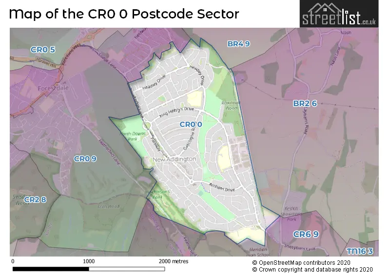
House Prices in the CR0 0 Postcode Sector
| Type of Property | 2018 Average | 2018 Sales | 2017 Average | 2017 Sales | 2016 Average | 2016 Sales | 2015 Average | 2015 Sales |
|---|---|---|---|---|---|---|---|---|
| Detached | £0 | 0 | £0 | 0 | £0 | 0 | £0 | 0 |
| Semi-Detached | £338,074 | 60 | £340,678 | 73 | £313,135 | 61 | £283,794 | 70 |
| Terraced | £338,028 | 47 | £324,511 | 47 | £310,365 | 48 | £272,524 | 40 |
| Flats | £227,389 | 18 | £239,945 | 10 | £227,664 | 21 | £194,736 | 22 |
Important Postcodes CR0 0 in the Postcode Sector
CR0 0AH is the postcode for SURREY BLOCK, Meridian High School, Fairchildes Avenue, KITCHEN & DINING BLOCK, Meridian High School, Fairchildes Avenue, KENT BLOCK, Meridian High School, Fairchildes Avenue, Fairchildes Primary School, Fairchildes Avenue, and KITCHEN & DINING ROOM, Meridian High School, Fairchildes Avenue
CR0 0EG is the postcode for Rowdown Primary School, Calley Down Crescent
CR0 0EP is the postcode for 47a, Calley Down Crescent, New Addington
CR0 0JA is the postcode for Parkway Health Centre, Parkway, and PARKWAY HEALTH CENTRE, PARKWAY, CROYDON
CR0 0JB is the postcode for New Addington Leisure Centre, Central Parade, NEW ADDINGTON LEISURE & COMMUNITY CENTRE, 88, Central Parade, New Addington, and London Borough of Croydon, New Addington Library, 90 Central Parade
CR0 0JD is the postcode for New Addington Centre, 61, Central Parade
CR0 0JJ is the postcode for THARREO HOUSE, Salcot Crescent, and Crescent Resource Centre, Salcot Crescent
CR0 0PA is the postcode for Tudor Academy, King Henrys Drive, New Addington, Tudor Academy, King Henrys Drive, and Wolsey Infant School, King Henrys Drive
CR0 0PL is the postcode for Goldcrest Club, Goldcrest Way
CR0 0QA is the postcode for New Addington Fire Station, 197-199 Lodge Lane
CR0 0RG is the postcode for School of the Good Shepherd, Dunley Drive, JUNIOR SCHOOL, School of the Good Shepherd, Dunley Drive, and INFANT SCHOOL, School of the Good Shepherd, Dunley Drive
CR0 0RJ is the postcode for Castle Hill Academy, Dunley Drive, MIDDLE YEAR BUILDING, Castle Hill Academy, Dunley Drive, and EARLY YEAR BUILDING, Castle Hill Academy, Dunley Drive
| The CR0 0 Sector is within these Local Authorities |
|
|---|---|
| The CR0 0 Sector is within these Counties |
|
| The CR0 0 Sector is within these Water Company Areas |
|