The CR0 3 postcode sector is within the county of Greater London.
Did you know? According to the 2021 Census, the CR0 3 postcode sector is home to a bustling 20,009 residents!
Given that each sector allows for 400 unique postcode combinations. Letters C, I, K, M, O and V are not allowed in the last two letters of a postcode. With 255 postcodes already in use, this leaves 145 units available.
The largest settlements in the CR0 3 postal code are CROYDON and BEDDINGTON .
The CR0 3 Postcode shares a border with CR4 1 (MITCHAM ), CR4 4 (MITCHAM , MITCHAM JUNCTION ), CR0 1 (CROYDON ), CR0 2 (CROYDON ), CR0 4 (CROYDON , BEDDINGTON , WALLINGTON ), CR7 6 (THORNTON HEATH ) and CR7 7 (THORNTON HEATH ).
The sector is within the post town of CROYDON.
CR0 3 is a postcode sector within the CR0 postcode district which is within the CR Croydon postcode area.
The Royal Mail delivery office for the CR0 3 postal sector is the unknown.
The area of the CR0 3 postcode sector is 1.02 square miles which is 2.64 square kilometres or 651.46 square acres.

Map of the CR0 3 Postcode Sector
Explore the CR0 3 postcode sector by using our free interactive map.
| C | R | 0 | - | 3 | X | X |
| C | R | 0 | Space | 3 | Letter | Letter |
Official List of Streets
CROYDON (108 Streets)
Unofficial Streets or Alternative Spellings
CROYDON
AMPERE WAY BEDDINGTON FARM ROAD COOMBER WAY CHURCH ALLEY CHURCHILL MEWS LOMBARD ROUNDABOUT ROMAN WAY WATNEYS ROADCROYDON,
PURLEY WAY THORNTON ROADTHORNTON HEATH
KESTON ROAD MAYDAY ROADMITCHAM
BEECH GROVE CASTLETON ROAD COMMONSIDE EAST CROYDON ROAD NEW BARNS AVENUECroydon
LONDON ROAD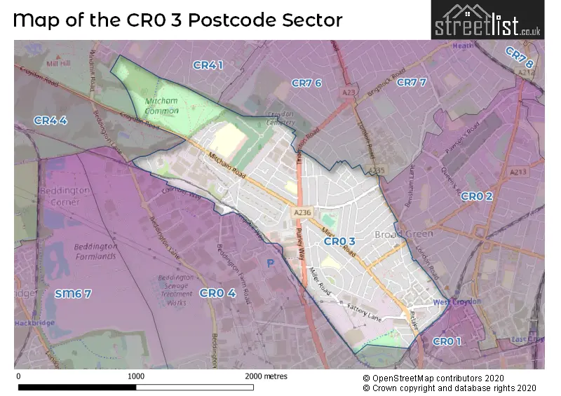
House Prices in the CR0 3 Postcode Sector
| Type of Property | 2018 Average | 2018 Sales | 2017 Average | 2017 Sales | 2016 Average | 2016 Sales | 2015 Average | 2015 Sales |
|---|---|---|---|---|---|---|---|---|
| Detached | £0 | 0 | £0 | 0 | £0 | 0 | £0 | 0 |
| Semi-Detached | £372,205 | 22 | £371,263 | 19 | £343,305 | 20 | £296,242 | 23 |
| Terraced | £340,806 | 98 | £338,141 | 112 | £321,983 | 142 | £278,680 | 116 |
| Flats | £187,538 | 43 | £222,317 | 41 | £200,790 | 30 | £197,978 | 49 |
Important Postcodes CR0 3 in the Postcode Sector
CR0 3AQ is the postcode for Department of Transport, Redhouse Road, and Driver and Vehicle Standards Agency, Redhouse Road
CR0 3BS is the postcode for WEST THORNTON PRIMARY SCHOOL, ROSECOURT ROAD, and West Thornton Primary Academy, Rosecourt Road
CR0 3DH is the postcode for London Borough of Sutton, Unit 1 Therapia Trading Estate, Therapia Lane
CR0 3HH is the postcode for WEST THORNTON PRIMARY ACADEMY, CANTERBURY ROAD
CR0 3JP is the postcode for Unit 3, 40 Purley Way, and London Fire Brigade, Unit 3
CR0 3JT is the postcode for Harris Primary Academy, Thomson Crescent, and Kingsley Primary Academy, Thomson Crescent
CR0 3RL is the postcode for Royal Mail, Croydon Delivery Office, 36-40 Factory Lane, and Cleanaway Ltd, Stubbs Mead Depot, Factory Lane
| The CR0 3 Sector is within these Local Authorities |
|
|---|---|
| The CR0 3 Sector is within these Counties |
|
| The CR0 3 Sector is within these Water Company Areas |
|