The CR0 4 postcode sector is within the county of Greater London.
Did you know? According to the 2021 Census, the CR0 4 postcode sector is home to a bustling 19,767 residents!
Given that each sector allows for 400 unique postcode combinations. Letters C, I, K, M, O and V are not allowed in the last two letters of a postcode. With 337 postcodes already in use, this leaves 63 units available.
The largest settlement in the CR0 4 postal code is CROYDON followed by BEDDINGTON , and WALLINGTON .
The CR0 4 Postcode shares a border with SM6 7 (WALLINGTON , HACKBRIDGE , BEDDINGTON ), SM6 8 (WALLINGTON ), SM6 9 (WALLINGTON ), CR4 4 (MITCHAM , MITCHAM JUNCTION ), CR0 1 (CROYDON ), CR0 3 (CROYDON , BEDDINGTON ) and CR2 6 (SOUTH CROYDON ).
The sector is within the post town of CROYDON.
CR0 4 is a postcode sector within the CR0 postcode district which is within the CR Croydon postcode area.
The Royal Mail delivery office for the CR0 4 postal sector is the unknown.
The area of the CR0 4 postcode sector is 2.16 square miles which is 5.60 square kilometres or 1,384.93 square acres.
Waterways within the CR0 4 postcode sector include the River Wandle.

Map of the CR0 4 Postcode Sector
Explore the CR0 4 postcode sector by using our free interactive map.
| C | R | 0 | - | 4 | X | X |
| C | R | 0 | Space | 4 | Letter | Letter |
Official List of Streets
CROYDON (165 Streets)
Unofficial Streets or Alternative Spellings
SOUTH CROYDON
WALDRONHYRST WARHAM ROADCROYDON
ABBEY ROAD BOURNE STREET BROOKMEAD ROAD CUTHBERT ROAD LOWER COOMBE STREET NEWMAN ROAD OLD TOWN THE CROYDON FLYOVER BEACON PLACE BEDDINGTON CROSS COLLYER ROAD COURTNEY PLACE DAVENANT ROAD ELAND PLACE FARADAY WAY GALVANI WAY LAWDON GARDENS MILE ROAD PETERSHAM TERRACE PROGRESS BUSINESS PARK PURLEY ROAD ROMAN WAY SILVERWING INDUSTRIAL ESTATE ST JOHNS ROAD STAFFORD CROSS THE TRAMSHEDS TURNERS WAY VALLEY PARK WADDON MARSH WAY WALDRONS PATHCROYDON,
PURLEY WAY STAFFORD ROADWALLINGTON
ARCHWAY CLOSE GUY ROAD PLOUGH LANE THE CHASE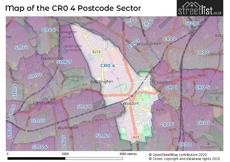
House Prices in the CR0 4 Postcode Sector
| Type of Property | 2018 Average | 2018 Sales | 2017 Average | 2017 Sales | 2016 Average | 2016 Sales | 2015 Average | 2015 Sales |
|---|---|---|---|---|---|---|---|---|
| Detached | £572,143 | 7 | £467,143 | 7 | £397,500 | 4 | £400,621 | 12 |
| Semi-Detached | £441,075 | 53 | £434,966 | 59 | £396,356 | 61 | £370,708 | 54 |
| Terraced | £369,268 | 79 | £348,713 | 64 | £339,798 | 77 | £313,878 | 82 |
| Flats | £239,477 | 88 | £254,284 | 133 | £247,699 | 196 | £257,517 | 369 |
Important Postcodes CR0 4 in the Postcode Sector
CR0 4BH is the postcode for THE NEST, The Minster Nursery & Infant School, Warrington Road, MAIN BUILDING, St. Andrews School, Warrington Road, The Minster Nursery & Infant School, Warrington Road, St. Andrews School, Warrington Road, The Minster Nursery and Infant School and The Minster Junior School, Warrington Road, and The Minster Infant & Junior Schools, Warrington Road
CR0 4DY is the postcode for Medical Clinic, 1a Coldharbour Road
CR0 4EJ is the postcode for Aerodrome Primary Academy, Goodwin Road, and Duppas Primary School, Goodwin Road
CR0 4FE is the postcode for HARRIS PRIMARY ACADEMY PURLEY WAY, 47 PROPELLER CRESCENT
CR0 4HA is the postcode for Croydon Educational Psychology Service, Victoria House, Southbridge Place
CR0 4HN is the postcode for Violet Lane Medical Practice, 231 Violet Lane
CR0 4HY is the postcode for Waddon Youth Centre, 85 Waddon Way
CR0 4PD is the postcode for The Link Secondary School, 82-84 Croydon Road, and The Link Secondary School, 82-84 Croydon Road, Beddington
CR0 4PG is the postcode for The Link Primary School, 138 Croydon Road, and The Link Primary School, 138 Croydon Road, Beddington
CR0 4RG is the postcode for Waddon Infant School, Purley Way, and Waddon Leisure Centre, 451 Purley Way
CR0 4RN is the postcode for Operations Support Centre, London Fire Brigade, Unit 1
CR0 4UA is the postcode for Beddington Park Primary School, Derry Road
CR0 4UL is the postcode for Beddington Park Academy, Mallinson Road
| The CR0 4 Sector is within these Local Authorities |
|
|---|---|
| The CR0 4 Sector is within these Counties |
|
| The CR0 4 Sector is within these Water Company Areas |
|