The CR0 5 postcode sector is within the county of Greater London.
Did you know? According to the 2021 Census, the CR0 5 postcode sector is home to a bustling 11,412 residents!
Given that each sector allows for 400 unique postcode combinations. Letters C, I, K, M, O and V are not allowed in the last two letters of a postcode. With 239 postcodes already in use, this leaves 161 units available.
The CR0 5 postal code covers the settlement of CROYDON .
The CR0 5 Postcode shares a border with BR4 9 (WEST WICKHAM ), CR0 6 (CROYDON ), CR0 7 (CROYDON ), CR0 8 (CROYDON ), CR2 8 (SOUTH CROYDON ), CR0 1 (CROYDON ), CR0 9 (CROYDON , FIELD WAY ) and CR2 7 (SOUTH CROYDON ).
The sector is within the post town of CROYDON.
CR0 5 is a postcode sector within the CR0 postcode district which is within the CR Croydon postcode area.
The Royal Mail delivery office for the CR0 5 postal sector is the unknown.
The area of the CR0 5 postcode sector is 2.89 square miles which is 7.47 square kilometres or 1,846.60 square acres.

Map of the CR0 5 Postcode Sector
Explore the CR0 5 postcode sector by using our free interactive map.
| C | R | 0 | - | 5 | X | X |
| C | R | 0 | Space | 5 | Letter | Letter |
Official List of Streets
CROYDON (126 Streets)
Unofficial Streets or Alternative Spellings
New Addington
LODGE LANECROYDON
BARCLAY ROAD BILLINTON HILL BLAKE ROAD CHERRY ORCHARD ROAD CLYDE ROAD COLSON ROAD GEORGE STREET HARTLAND WAY SHIRLEY ROAD SOUTH WAY ST. ARVANS CLOSE WEST WAY WEST WAY GARDENS WICKHAM ROAD BRIDLE ROAD HAZLEDEAN ROAD NEW PLACE SISKIN COURT ST BERNARDS SUNKEN ROAD THANESCROFT COURT THE DENE THE PADDOCKSSOUTH CROYDON
BIRDHURST AVENUE BIRDHURST ROAD CAMPDEN ROAD CASTLEMAINE AVENUE CHAPEL VIEW CROHAM PARK AVENUE CROSSWAYS KERR CLOSE SOUTH PARK HILL ROADCROYDON,
BALLARDS FARM ROAD BALLARDS WAY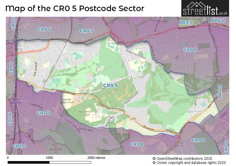
House Prices in the CR0 5 Postcode Sector
| Type of Property | 2018 Average | 2018 Sales | 2017 Average | 2017 Sales | 2016 Average | 2016 Sales | 2015 Average | 2015 Sales |
|---|---|---|---|---|---|---|---|---|
| Detached | £885,499 | 38 | £850,639 | 29 | £895,500 | 28 | £719,179 | 28 |
| Semi-Detached | £605,667 | 12 | £501,471 | 17 | £507,333 | 6 | £446,775 | 16 |
| Terraced | £462,398 | 31 | £499,013 | 36 | £457,655 | 29 | £414,822 | 30 |
| Flats | £234,080 | 106 | £295,854 | 78 | £302,715 | 81 | £258,722 | 123 |
Important Postcodes CR0 5 in the Postcode Sector
CR0 5AQ is the postcode for Metropolitan Police, Police Station, Addington Village Road
CR0 5EF is the postcode for Block F, Shirley High School, Shirley Church Road, MATHS BLOCK, Shirley High School, Shirley Church Road, BLOCK E, Shirley High School, Shirley Church Road, Shirley High School, Shirley Church Road, SPORTS HALL ., Shirley High School, Shirley Church Road, FOOD TECHNOLOGY BLOCK, Shirley High School, Shirley Church Road, BLOCK A, Shirley High School, Shirley Church Road, Main Block, Shirley High School, Shirley Church Road, and BLOCK C, Shirley High School, Shirley Church Road
CR0 5EL is the postcode for St. Johns Church of England (V.A.) School, Spring Park Road, St John's C of E Primary School, Spring Park Road, Shirley, and St Johns Church Of England Primary School, Spring Park Road
CR0 5JF is the postcode for Wilhelmena House, 21 Park Hill Rise
CR0 5JQ is the postcode for ARCHBISHOP TENNISONS CHURCH OF ENGLAND SCHOOL, SELBORNE ROAD, CROYDON, Archbishop Tenisons C of E School, Selborne Road, SPORTS HALL, Archbishop Tenisons C of E School, Selborne Road, and Archbishop Tennisons Church Of England School, Selborne Road
CR0 5NS is the postcode for PARK HILL JUNIOR SCHOOL SITE, Park Hill Junior School, Stanhope Road, Park Hill Infant School, Stanhope Road, and Park Hill Junior School, Stanhope Road
CR0 5RD is the postcode for Geoffrey Harris House, Coombe Road
CR0 5RH is the postcode for Heathfield, Coombe Lane
| The CR0 5 Sector is within these Local Authorities |
|
|---|---|
| The CR0 5 Sector is within these Counties |
|
| The CR0 5 Sector is within these Water Company Areas |
|