The CR0 6 postcode sector is within the county of Greater London.
Did you know? According to the 2021 Census, the CR0 6 postcode sector is home to a bustling 23,284 residents!
Given that each sector allows for 400 unique postcode combinations. Letters C, I, K, M, O and V are not allowed in the last two letters of a postcode. With 310 postcodes already in use, this leaves 90 units available.
The CR0 6 postal code covers the settlement of CROYDON .
The CR0 6 Postcode shares a border with CR0 5 (CROYDON ), CR0 7 (CROYDON ), SE25 4 (SOUTH NORWOOD ), SE25 5 (SOUTH NORWOOD ), CR0 1 (CROYDON ) and CR0 2 (CROYDON ).
The sector is within the post town of CROYDON.
CR0 6 is a postcode sector within the CR0 postcode district which is within the CR Croydon postcode area.
The Royal Mail delivery office for the CR0 6 postal sector is the unknown.
The area of the CR0 6 postcode sector is 0.81 square miles which is 2.09 square kilometres or 515.92 square acres.

Map of the CR0 6 Postcode Sector
Explore the CR0 6 postcode sector by using our free interactive map.
| C | R | 0 | - | 6 | X | X |
| C | R | 0 | Space | 6 | Letter | Letter |
Official List of Streets
CROYDON (110 Streets)
Unofficial Streets or Alternative Spellings
CROYDON
ADDISCOMBE GROVE BINGHAM ROAD BROCKENHURST ROAD FERNHURST ROAD KINGSCOTE ROAD LEYBURN GARDENS PARK HILL RISE PARKVIEW ROAD SHERWOOD ROAD SHIRLEY ROAD STROUD GREEN WAY WOODBURY CLOSE ADDISCOMBE RAILWAY PARK ALEXANDRA PLACE BRIDGE ROW CRABTREE WALK DALMALLY PASSAGE EDWIN PLACE HERON ROAD JACKSONS PLACE REGENT PLACE THE NARROWS WYDENHURST ROADCroydon
BACKLEY GARDENS HERMITAGE LANE SONNING ROAD TENNISON ROAD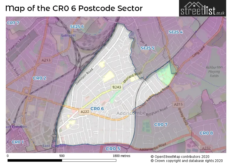
House Prices in the CR0 6 Postcode Sector
| Type of Property | 2018 Average | 2018 Sales | 2017 Average | 2017 Sales | 2016 Average | 2016 Sales | 2015 Average | 2015 Sales |
|---|---|---|---|---|---|---|---|---|
| Detached | £586,688 | 8 | £645,000 | 2 | £467,765 | 4 | £477,557 | 11 |
| Semi-Detached | £500,244 | 32 | £473,842 | 19 | £428,665 | 40 | £380,073 | 41 |
| Terraced | £396,052 | 124 | £403,420 | 116 | £389,917 | 132 | £341,435 | 174 |
| Flats | £315,441 | 128 | £344,591 | 384 | £293,651 | 166 | £220,453 | 175 |
Important Postcodes CR0 6 in the Postcode Sector
CR0 6AH is the postcode for Stovell House Surgery, 188 Lower Addiscombe Road
CR0 6BA is the postcode for Sheppard Building, Ark Oval Primary Academy, 98 Cherry Orchard Road, Croydon Business Venture Ltd, Acorn House, 74-94 Cherry Orchard Road, BEAUMONT BUILDING, Ark Oval Primary Academy, 98 Cherry Orchard Road, and Ark Oval Primary Academy, 98 Cherry Orchard Road
CR0 6DD is the postcode for Croydon College, Davidson Campus
CR0 6JA is the postcode for Davidson Primary Academy, Dartnell Road, and John Wood School and Nursery, Dartnell Road
CR0 6JB is the postcode for Davidson Infant & Junior School, Dartnell Road
CR0 6JN is the postcode for BLOCK D, Robert Fitzroy Academy, 80 Brampton Road, THE ROBERT FITZROY ACADEMY, 80 BRAMPTON ROAD, CROYDON, The Robert Fitzroy Academy, 80 Brampton Road, and Robert Fitzroy Academy, 80 Brampton Road
CR0 6NA is the postcode for Chaffinch Brook, (Part of Beckmead School Family), 32-34 Morland Road, Ark Blake Academy, 6 Morland Road, London Borough of Croydon, Morland Lodge, 4 Morland Road, London Borough of Croydon, Rees House, 2 Morland Road, and Community & Voluntary Services, Rees House, 2 Morland Road
CR0 6NF is the postcode for CHILDREN'S CENTRE, The Woodside Academy, Morland Road, The Woodside Academy, Morland Road, UPPER SCHOOL, The Woodside Academy, Morland Road, LOWER SCHOOL, The Woodside Academy, Morland Road, and Woodside Primary School & Childrens Centre, Morland Road
CR0 6SD is the postcode for East Croydon Medical Centre, 59 Addiscombe Road
CR0 6SR is the postcode for British Transport Police, Knollys House
CR0 6TY is the postcode for Tunstall Nursery School, 27 Tunstall Road
| The CR0 6 Sector is within these Local Authorities |
|
|---|---|
| The CR0 6 Sector is within these Counties |
|
| The CR0 6 Sector is within these Water Company Areas |
|