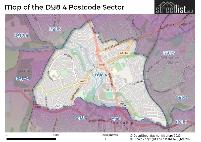
The DY8 4 postcode sector stands on the Staffordshire and West Midlands border.
Did you know? According to the 2021 Census, the DY8 4 postcode sector is home to a bustling 14,119 residents!
Given that each sector allows for 400 unique postcode combinations. Letters C, I, K, M, O and V are not allowed in the last two letters of a postcode. With 289 postcodes already in use, this leaves 111 units available.
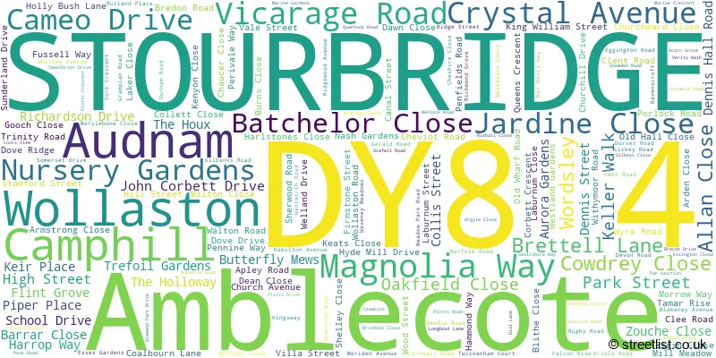
The largest settlement in the DY8 4 postal code is STOURBRIDGE followed by Wollaston, and Amblecote.
The DY8 4 Postcode shares a border with DY5 2 (BRIERLEY HILL, Quarry Bank), DY5 3 (BRIERLEY HILL, Brockmoor), DY7 5 (Enville, Bobbington, STOURBRIDGE), DY8 5 (STOURBRIDGE, Wordsley), DY7 6 (Kinver, Stourton, STOURBRIDGE), DY8 1 (STOURBRIDGE), DY8 3 (STOURBRIDGE, Wollaston) and DY9 7 (STOURBRIDGE).
The sector is within the post town of STOURBRIDGE.
DY8 4 is a postcode sector within the DY8 postcode district which is within the DY Dudley postcode area.
The Royal Mail delivery office for the DY8 4 postal sector is the Stourbridge Delivery Office.
The area of the DY8 4 postcode sector is 1.18 square miles which is 3.07 square kilometres or 758.13 square acres.
Waterways within the DY8 4 postcode sector include the Stourbridge Canal, Stourbridge Town Arm, River Stour.

Map of the DY8 4 Postcode Sector
Explore the DY8 4 postcode sector by using our free interactive map.
| D | Y | 8 | - | 4 | X | X |
| D | Y | 8 | Space | 4 | Letter | Letter |
Official List of Streets
STOURBRIDGE (155 Streets)
Wollaston (10 Streets)
Amblecote (7 Streets)
Audnam (1 Streets)
Unofficial Streets or Alternative Spellings
BRIERLEY HILL
STAMFORD ROADSTOURBRIDGE
BRIDGE STREET HARLSTONES CLOSE HARRISON ROAD MILL RACE LANE OAK PARK ROAD PARK STREET SUTTON STREETWordsley
BROOK STREET HIGH STREET CAROL GARDENS HOLLYBUSH LANE MEADOWPARK ROAD NEVILLE GARRATT BRIDGE THE CRESCENT VINE STREETBRIERLEY HILL,
BRETTELL LANEStourton
HYPERION ROADWeather Forecast for DY8 4
Press Button to Show Forecast for Amblecote
| Time Period | Icon | Description | Temperature | Rain Probability | Wind |
|---|---|---|---|---|---|
| 21:00 to 00:00 | Clear night | 12.0°C (feels like 11.0°C) | 0.00% | N 4 mph |
Press Button to Show Forecast for Amblecote
| Time Period | Icon | Description | Temperature | Rain Probability | Wind |
|---|---|---|---|---|---|
| 00:00 to 03:00 | Clear night | 10.0°C (feels like 10.0°C) | 0.00% | N 2 mph | |
| 03:00 to 06:00 | Clear night | 8.0°C (feels like 7.0°C) | 0.00% | NNW 2 mph | |
| 06:00 to 09:00 | Sunny day | 9.0°C (feels like 8.0°C) | 0.00% | W 2 mph | |
| 09:00 to 12:00 | Sunny day | 14.0°C (feels like 14.0°C) | 0.00% | SSE 2 mph | |
| 12:00 to 15:00 | Cloudy | 17.0°C (feels like 16.0°C) | 5.00% | SSW 4 mph | |
| 15:00 to 18:00 | Cloudy | 18.0°C (feels like 16.0°C) | 8.00% | SSE 4 mph | |
| 18:00 to 21:00 | Cloudy | 16.0°C (feels like 15.0°C) | 7.00% | SSW 4 mph | |
| 21:00 to 00:00 | Cloudy | 14.0°C (feels like 13.0°C) | 5.00% | SSW 4 mph |
Press Button to Show Forecast for Amblecote
| Time Period | Icon | Description | Temperature | Rain Probability | Wind |
|---|---|---|---|---|---|
| 00:00 to 03:00 | Cloudy | 12.0°C (feels like 12.0°C) | 5.00% | WNW 2 mph | |
| 03:00 to 06:00 | Cloudy | 11.0°C (feels like 10.0°C) | 5.00% | NW 4 mph | |
| 06:00 to 09:00 | Cloudy | 11.0°C (feels like 10.0°C) | 6.00% | NNW 4 mph | |
| 09:00 to 12:00 | Cloudy | 14.0°C (feels like 13.0°C) | 7.00% | N 4 mph | |
| 12:00 to 15:00 | Cloudy | 17.0°C (feels like 16.0°C) | 9.00% | NNE 7 mph | |
| 15:00 to 18:00 | Cloudy | 17.0°C (feels like 16.0°C) | 12.00% | NNE 7 mph | |
| 18:00 to 21:00 | Light rain shower (day) | 16.0°C (feels like 14.0°C) | 33.00% | N 7 mph | |
| 21:00 to 00:00 | Cloudy | 13.0°C (feels like 11.0°C) | 7.00% | NNW 7 mph |
Press Button to Show Forecast for Amblecote
| Time Period | Icon | Description | Temperature | Rain Probability | Wind |
|---|---|---|---|---|---|
| 00:00 to 03:00 | Clear night | 11.0°C (feels like 9.0°C) | 1.00% | NNW 7 mph | |
| 03:00 to 06:00 | Cloudy | 10.0°C (feels like 9.0°C) | 5.00% | NNW 7 mph | |
| 06:00 to 09:00 | Cloudy | 11.0°C (feels like 9.0°C) | 6.00% | NNW 7 mph | |
| 09:00 to 12:00 | Cloudy | 13.0°C (feels like 12.0°C) | 6.00% | N 7 mph | |
| 12:00 to 15:00 | Cloudy | 16.0°C (feels like 15.0°C) | 5.00% | N 7 mph | |
| 15:00 to 18:00 | Cloudy | 18.0°C (feels like 17.0°C) | 6.00% | NNW 7 mph | |
| 18:00 to 21:00 | Cloudy | 17.0°C (feels like 16.0°C) | 5.00% | N 7 mph | |
| 21:00 to 00:00 | Partly cloudy (night) | 13.0°C (feels like 12.0°C) | 1.00% | N 7 mph |
Press Button to Show Forecast for Amblecote
| Time Period | Icon | Description | Temperature | Rain Probability | Wind |
|---|---|---|---|---|---|
| 00:00 to 03:00 | Cloudy | 11.0°C (feels like 10.0°C) | 4.00% | NNE 4 mph | |
| 03:00 to 06:00 | Cloudy | 9.0°C (feels like 8.0°C) | 4.00% | NE 4 mph | |
| 06:00 to 09:00 | Cloudy | 10.0°C (feels like 9.0°C) | 5.00% | NE 4 mph | |
| 09:00 to 12:00 | Cloudy | 13.0°C (feels like 13.0°C) | 4.00% | ENE 4 mph | |
| 12:00 to 15:00 | Cloudy | 17.0°C (feels like 16.0°C) | 4.00% | NNW 4 mph | |
| 15:00 to 18:00 | Cloudy | 18.0°C (feels like 18.0°C) | 4.00% | SSW 4 mph | |
| 18:00 to 21:00 | Cloudy | 18.0°C (feels like 17.0°C) | 4.00% | WSW 4 mph | |
| 21:00 to 00:00 | Cloudy | 15.0°C (feels like 14.0°C) | 3.00% | W 4 mph |
Schools and Places of Education Within the DY8 4 Postcode Sector
Amblecote Primary School
Community school
School Drive, Stourbridge, West Midlands, DY8 4DQ
Head: Mrs Jane Cook
Ofsted Rating: Good
Inspection: 2022-03-23 (773 days ago)
Website: Visit Amblecote Primary School Website
Phone: 01384818335
Number of Pupils: 307
Glasshouse College
Special post 16 institution
Wollaston Road, Stourbridge, West Midlands, DY8 4HF
Head: Mr Alex Griffin
Ofsted Rating: Good
Inspection: 2021-10-14 (933 days ago)
Website: Visit Glasshouse College Website
Phone: 01384399400
Number of Pupils: 0
St James's CofE Primary School
Voluntary aided school
Kingsway, Stourbridge, West Midlands, DY8 4RU
Head: Mrs Natalie Sefton
Ofsted Rating: Good
Inspection: 2023-06-28 (311 days ago)
Website: Visit St James's CofE Primary School Website
Phone: 01384818810
Number of Pupils: 417
House Prices in the DY8 4 Postcode Sector
| Type of Property | 2018 Average | 2018 Sales | 2017 Average | 2017 Sales | 2016 Average | 2016 Sales | 2015 Average | 2015 Sales |
|---|---|---|---|---|---|---|---|---|
| Detached | £256,348 | 50 | £263,492 | 78 | £258,238 | 84 | £254,388 | 78 |
| Semi-Detached | £177,525 | 104 | £181,095 | 96 | £173,255 | 116 | £163,905 | 113 |
| Terraced | £157,666 | 54 | £177,213 | 67 | £151,060 | 63 | £133,193 | 74 |
| Flats | £115,643 | 28 | £135,436 | 53 | £115,076 | 56 | £95,000 | 17 |
Important Postcodes DY8 4 in the Postcode Sector
DY8 4AP is the postcode for DUDLEY PCT, Hollybush House, Vicarage Road
DY8 4AZ is the postcode for Red House Glass Cone, Wordsley, High Street
DY8 4BP is the postcode for The Unicorn Centre, Brettell Lane, and The Crystal Gateway, Brettell Lane Centre, Brettell Lane
DY8 4DG is the postcode for Hill House, High Street
DY8 4DQ is the postcode for Amblecote Primary School, School Drive
DY8 4HZ is the postcode for Stourbridge Social Care & Health Centre, John Corbett Drive
DY8 4JB is the postcode for SUNFLOWER CENTRE, Dudley Group Of Hospitals NHS Trust, Corbett Hospital, Stourbridge Health & Social Care Centre, John Corbett Drive, HOLLYBUSH HOUSE, Dudley Group Of Hospitals NHS Trust, Corbett Hospital, Corbett Hospital, Vicarage Road, and Dudley Group Of Hospitals NHS Trust, Corbett Hospital
DY8 4RU is the postcode for St. James C of E Primary School, Kingsway
| The DY8 4 Sector is within these Local Authorities |
|
|---|---|
| The DY8 4 Sector is within these Counties |
|
| The DY8 4 Sector is within these Water Company Areas |
|
Tourist Attractions within the DY8 4 Postcode Area
We found 1 visitor attractions within the DY8 postcode area
| Red House Glass Cone |
|---|
| Historic Properties |
| Historic Monument / Archaeological Site |
| View Red House Glass Cone on Google Maps |