Given that each sector allows for 400 unique postcode combinations. Letters C, I, K, M, O and V are not allowed in the last two letters of a postcode. With 195 postcodes already in use, this leaves 205 units available.
The EH13 0 postal code covers the settlement of EDINBURGH.
The EH13 0 Postcode shares a border with EH14 3 (EDINBURGH), EH14 6 (CURRIE), EH10 7 (EDINBURGH), EH13 9 (EDINBURGH), EH14 1 (EDINBURGH), EH14 2 (EDINBURGH), EH14 5 (CURRIE, JUNIPER GREEN, BALERNO) and EH26 0 (PENICUIK, Milton Bridge, Auchendinny).
The sector is within the post town of EDINBURGH.
EH13 0 is a postcode sector within the EH13 postcode district which is within the EH Edinburgh postcode area.
The Royal Mail delivery office for the EH13 0 postal sector is the Edinburgh Dell Delivery Office.
The area of the EH13 0 postcode sector is 3.70 square miles which is 9.58 square kilometres or 2,366.08 square acres.

Map of the EH13 0 Postcode Sector
Explore the EH13 0 postcode sector by using our free interactive map.
| E | H | 1 | 3 | - | 0 | X | X |
| E | H | 1 | 3 | Space | 0 | Letter | Letter |
Official List of Streets
EDINBURGH (82 Streets)
Unofficial Streets or Alternative Spellings
EDINBURGH
COLINTON MAINS DRIVE DREGHORN LINK ELLIOT GARDENS ELLIOT PLACE OXGANGS ROAD NORTH ASSAULT COURSE BONALY FARM COTTAGES CAPELAW BYPASS CAPELAW HILL CITY OF EDINBURGH BYPASS COLINTON MAINS GARDEN CUDDIES LANE DREGHORN DROP EASTER HAILES GATE NEW DROVERS PATH NIBBLER OLD FARM COURT PHANTOMS CLEUGH REDFORD HOUSE ESTATE SPYLAW HOUSE THE CITY OF EDINBURGH BYPASS THE LONG STEPS THE SHOOT THE TURLIES WATER OF LEITH WALKWAYEDINBURGH,
LANARK ROAD WESTER HAILES ROAD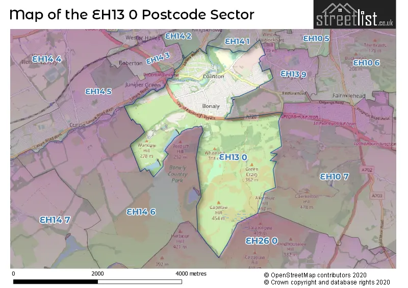
| The EH13 0 Sector is within these Local Authorities | |
|---|---|
| The EH13 0 Sector is within these Counties | |
| The EH13 0 Sector is within these Water Company Areas |