Given that each sector allows for 400 unique postcode combinations. Letters C, I, K, M, O and V are not allowed in the last two letters of a postcode. With 183 postcodes already in use, this leaves 217 units available.
The EH13 9 postal code covers the settlement of EDINBURGH.
The EH13 9 Postcode shares a border with EH10 5 (EDINBURGH), EH10 6 (EDINBURGH), EH10 7 (EDINBURGH), EH13 0 (EDINBURGH) and EH14 1 (EDINBURGH).
The sector is within the post town of EDINBURGH.
EH13 9 is a postcode sector within the EH13 postcode district which is within the EH Edinburgh postcode area.
The Royal Mail delivery office for the EH13 9 postal sector is the Edinburgh Dell Delivery Office.
The area of the EH13 9 postcode sector is 0.82 square miles which is 2.12 square kilometres or 523.69 square acres.


Map of the EH13 9 Postcode Sector
Explore the EH13 9 postcode sector by using our free interactive map.
| E | H | 1 | 3 | - | 9 | X | X |
| E | H | 1 | 3 | Space | 9 | Letter | Letter |
Official List of Streets
EDINBURGH (59 Streets)
Unofficial Streets or Alternative Spellings
EDINBURGH
CAIYSTANE GARDENS CAIYSTANE TERRACE DREGHORN LOAN FOX SPRING CRESCENT GREENBANK CRESCENT NEW SWANSTON SWANSTON MUIR BYREHOPE WAY CAERKETTON CRESCENT CHATTERIG CITY OF EDINBURGH BYPASS COCKIT HAT COCKMYLANE COLINTON MAINS GARDEN DREGHORN AVENUE DREGHORN BARRACKS MACFIE LOAN SCALD LAW DRIVE SHEARIE KNOWE GARDENS THE BACK PATH THE CITY OF EDINBURGH BYPASS WEST CAMUS PATH WHITE LADY WALK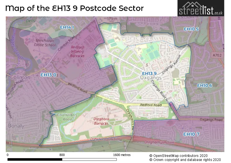
| The EH13 9 Sector is within these Local Authorities | |
|---|---|
| The EH13 9 Sector is within these Counties | |
| The EH13 9 Sector is within these Water Company Areas |