Given that each sector allows for 400 unique postcode combinations. Letters C, I, K, M, O and V are not allowed in the last two letters of a postcode. With 321 postcodes already in use, this leaves 79 units available.
The EH17 8 postal code covers the settlement of EDINBURGH.
The EH17 8 Postcode shares a border with EH16 4 (EDINBURGH), EH10 7 (EDINBURGH), EH17 7 (EDINBURGH), EH16 6 (EDINBURGH), EH22 1 (DALKEITH, Danderhall, Newton Village), EH18 1 (LASSWADE) and EH20 9 (LOANHEAD, Straiton).
The sector is within the post town of EDINBURGH.
EH17 8 is a postcode sector within the EH17 postcode district which is within the EH Edinburgh postcode area.
The Royal Mail delivery office for the EH17 8 postal sector is the Edinburgh Sedelivery Office.
The area of the EH17 8 postcode sector is 2.92 square miles which is 7.56 square kilometres or 1,867.30 square acres.


Map of the EH17 8 Postcode Sector
Explore the EH17 8 postcode sector by using our free interactive map.
| E | H | 1 | 7 | - | 8 | X | X |
| E | H | 1 | 7 | Space | 8 | Letter | Letter |
Official List of Streets
EDINBURGH (200 Streets)
Unofficial Streets or Alternative Spellings
EDINBURGH
FERNIEHILL DRIVE FROGSTON ROAD WEST GRACEMOUNT DRIVE GRACEMOUNT ROAD HOWDEN HALL ROADEDINBURGH,
GILMERTON ROAD BANNERMAN CRUIK BROOMHILLS ROAD CITY OF EDINBURGH BYPASS CROOSTON CRESCENT DRUM COURT FORDELL WAY FOUNDRY LANE GRUNDIES WELL ROAD INNES GAIT LANG LOAN SOUTHOUSE CROSSWAY SOUTHOUSE PLACE THE CITY OF EDINBURGH BYPASSStraiton
STRAITON ROAD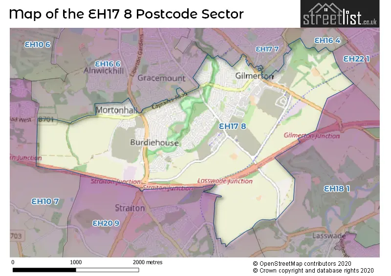
| The EH17 8 Sector is within these Local Authorities | |
|---|---|
| The EH17 8 Sector is within these Counties | |
| The EH17 8 Sector is within these Water Company Areas |