Given that each sector allows for 400 unique postcode combinations. Letters C, I, K, M, O and V are not allowed in the last two letters of a postcode. With 205 postcodes already in use, this leaves 195 units available.
The EH5 3 postal code covers the settlement of EDINBURGH.
The EH5 3 Postcode shares a border with EH3 5 (EDINBURGH), EH5 1 (EDINBURGH), EH5 2 (EDINBURGH), EH6 4 (EDINBURGH) and EH7 4 (EDINBURGH).
The sector is within the post town of EDINBURGH.
EH5 3 is a postcode sector within the EH5 postcode district which is within the EH Edinburgh postcode area.
The Royal Mail delivery office for the EH5 3 postal sector is the Leith Delivery Office 5.
The area of the EH5 3 postcode sector is 0.41 square miles which is 1.07 square kilometres or 264.15 square acres.

Map of the EH5 3 Postcode Sector
Explore the EH5 3 postcode sector by using our free interactive map.
| E | H | 5 | - | 3 | X | X |
| E | H | 5 | Space | 3 | Letter | Letter |
Official List of Streets
EDINBURGH (70 Streets)
Unofficial Streets or Alternative Spellings
EDINBURGH
BOSWALL GREEN CRAIGHALL CRESCENT CRAIGHALL ROAD FRASER AVENUE GRIERSON AVENUE INVERLEITH ROW MONMOUTH TERRACE STANLEY ROAD WARDIE STEPS WARRISTON ROAD BANGHOLM WOODS SINGLETRACK CHANCELOT PATH FERRY ROAD PATH GOLDENACRE PATH HAWTHORNVALE PATH MCKELVIE PARADE TRINITY PATH TRINITY TUNNEL VICTORIA SQUARE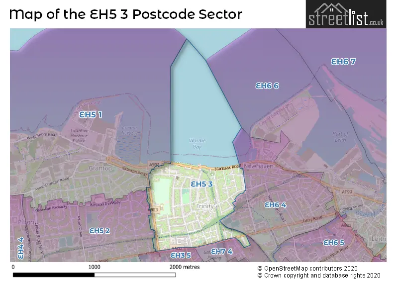
| The EH5 3 Sector is within these Local Authorities | |
|---|---|
| The EH5 3 Sector is within these Counties | |
| The EH5 3 Sector is within these Water Company Areas |