Given that each sector allows for 400 unique postcode combinations. Letters C, I, K, M, O and V are not allowed in the last two letters of a postcode. With 227 postcodes already in use, this leaves 173 units available.
The largest settlement in the EH52 5 postal code is BROXBURN followed by Uphall, and East Mains Industrial Estate.
The EH52 5 Postcode shares a border with EH29 9 (KIRKLISTON), EH28 8 (Ratho, NEWBRIDGE, Ratho Station), EH52 6 (Winchburgh, BROXBURN, Uphall), EH53 0 (East Calder, Mid Calder, Pumpherston) and EH54 5 (LIVINGSTON, Uphall Station, Houstoun Industrial Estate).
The sector is within the post town of BROXBURN.
EH52 5 is a postcode sector within the EH5 postcode district which is within the EH Edinburgh postcode area.
The Royal Mail delivery office for the EH52 5 postal sector is the unknown.
The area of the EH52 5 postcode sector is 5.84 square miles which is 15.12 square kilometres or 3,737.09 square acres.

Map of the EH52 5 Postcode Sector
Explore the EH52 5 postcode sector by using our free interactive map.
| E | H | 5 | 2 | - | 5 | X | X |
| E | H | 5 | 2 | Space | 5 | Letter | Letter |
Official List of Streets
BROXBURN (95 Streets)
Uphall (26 Streets)
East Mains Industrial Estate (10 Streets)
Unofficial Streets or Alternative Spellings
BROXBURN
BUCHAN ROAD CARDROSS ROAD CLEGHORN DRIVE FREELAND AVENUE KIRKHILL PARK KIRKHILL ROAD PORT BUCHANPumpherston
DRUMSHORELAND ROADUphall
ECCLESMACHAN ROAD FORKNEUK ROAD LOANFOOT ROAD STRATHBROCK PLACE WYNDFORD AVENUEUphall Station
JAMES YOUNG AVENUEBROXBURN,
EDINBURGH ROAD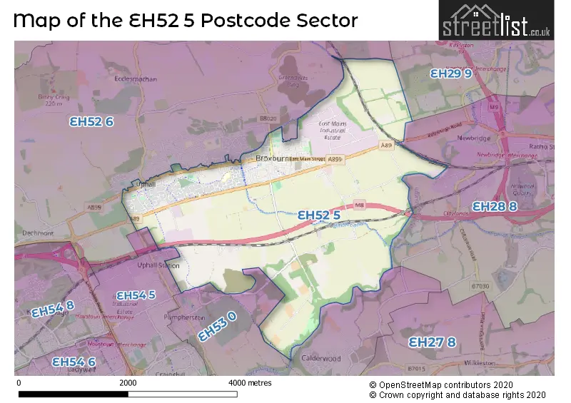
| The EH52 5 Sector is within these Local Authorities | |
|---|---|
| The EH52 5 Sector is within these Counties | |
| The EH52 5 Sector is within these Water Company Areas |