Given that each sector allows for 400 unique postcode combinations. Letters C, I, K, M, O and V are not allowed in the last two letters of a postcode. With 309 postcodes already in use, this leaves 91 units available.
The largest settlement in the EH52 6 postal code is Winchburgh followed by BROXBURN, and Uphall.
The EH52 6 Postcode shares a border with EH29 9 (KIRKLISTON), EH48 1 (BATHGATE), EH48 4 (BATHGATE, Torphichen), EH30 9 (SOUTH QUEENSFERRY, Dalmeny, Craigiehall), EH54 8 (LIVINGSTON, Deans), EH49 6 (LINLITHGOW, Bridgend, Whitecross), EH49 7 (LINLITHGOW, Linlithgow Bridge, Blackness), EH52 5 (BROXBURN, Uphall, East Mains Industrial Estate) and EH54 5 (LIVINGSTON, Uphall Station, Houstoun Industrial Estate).
The sector is within the post town of BROXBURN.
EH52 6 is a postcode sector within the EH5 postcode district which is within the EH Edinburgh postcode area.
The Royal Mail delivery office for the EH52 6 postal sector is the unknown.
The area of the EH52 6 postcode sector is 14.23 square miles which is 36.85 square kilometres or 9,105.05 square acres.

Map of the EH52 6 Postcode Sector
Explore the EH52 6 postcode sector by using our free interactive map.
| E | H | 5 | 2 | - | 6 | X | X |
| E | H | 5 | 2 | Space | 6 | Letter | Letter |
Official List of Streets
Winchburgh (65 Streets)
Dechmont (13 Streets)
BROXBURN (63 Streets)
Ecclesmachan (3 Streets)
Uphall (27 Streets)
Unofficial Streets or Alternative Spellings
BROXBURN
CHURCH STREET LUMSDEN COURTUphall
HAWTHORN PLACE MILLBANK PLACE STATION ROAD WEST MAIN STREET BADGER WOOD CLARKSON ROAD CLUB HOUSE ROAD CUNNINGHAR ROAD DECHMONT ROUNDABOUT DEVON LANE DUDDINGSTONE TERRACE EASTERN DISTRIBUTOR ROAD FARINSFELL GATE DEMONSTRATION AREA GLENTROOL BRIDGE HOUSTON MAINS HOLDINGS LADY WALK LIVINGSTON ROAD LOAN PATH NORTH GREENDYKES ROAD RAILWAY PATH SOUTH RASHIERIGG STONEBYRES CRESCENT TIMBER BRIDGE UNION CANAL TOWPATH WELLPARKBridgend
AULDHILL ROAD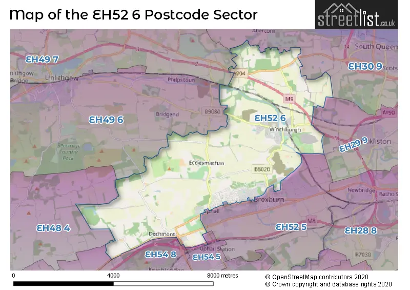
| The EH52 6 Sector is within these Local Authorities | |
|---|---|
| The EH52 6 Sector is within these Counties | |
| The EH52 6 Sector is within these Water Company Areas |