Given that each sector allows for 400 unique postcode combinations. Letters C, I, K, M, O and V are not allowed in the last two letters of a postcode. With 288 postcodes already in use, this leaves 112 units available.
The EH54 6 postal code covers the settlement of LIVINGSTON.
The EH54 6 Postcode shares a border with EH54 7 (LIVINGSTON, Livingston Village, Kirkton Campus), EH54 8 (LIVINGSTON, Deans), EH53 0 (East Calder, Mid Calder, Pumpherston), EH54 5 (LIVINGSTON, Uphall Station, Houstoun Industrial Estate) and EH54 9 (LIVINGSTON, Murieston, Bellsquarry).
The sector is within the post town of LIVINGSTON.
EH54 6 is a postcode sector within the EH5 postcode district which is within the EH Edinburgh postcode area.
The Royal Mail delivery office for the EH54 6 postal sector is the unknown.
The area of the EH54 6 postcode sector is 2.75 square miles which is 7.13 square kilometres or 1,762.85 square acres.

Map of the EH54 6 Postcode Sector
Explore the EH54 6 postcode sector by using our free interactive map.
| E | H | 5 | 4 | - | 6 | X | X |
| E | H | 5 | 4 | Space | 6 | Letter | Letter |
Official List of Streets
LIVINGSTON (156 Streets)
Unofficial Streets or Alternative Spellings
LIVINGSTON
APPLETON PARKWAY BANKTON LANELivingston Village
KIRKTON NORTH ROAD MAIN STREETHoustoun Industrial Estate
HOUSTOUN ROADKirkton Campus
SIMPSON PARKWAY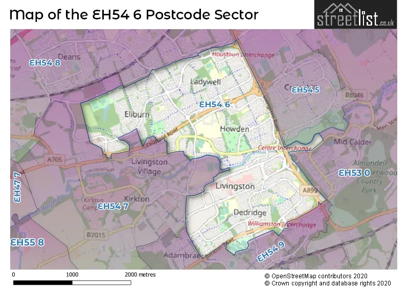
| The EH54 6 Sector is within these Local Authorities | |
|---|---|
| The EH54 6 Sector is within these Counties | |
| The EH54 6 Sector is within these Water Company Areas |