Given that each sector allows for 400 unique postcode combinations. Letters C, I, K, M, O and V are not allowed in the last two letters of a postcode. With 191 postcodes already in use, this leaves 209 units available.
The EH7 4 postal code covers the settlement of EDINBURGH.
The EH7 4 Postcode shares a border with EH3 5 (EDINBURGH), EH1 3 (EDINBURGH), EH3 6 (EDINBURGH), EH5 3 (EDINBURGH), EH6 4 (EDINBURGH), EH6 5 (EDINBURGH), EH6 8 (EDINBURGH) and EH7 5 (EDINBURGH).
The sector is within the post town of EDINBURGH.
EH7 4 is a postcode sector within the EH7 postcode district which is within the EH Edinburgh postcode area.
The Royal Mail delivery office for the EH7 4 postal sector is the Edinburgh East Central Delivery Office.
The area of the EH7 4 postcode sector is 0.44 square miles which is 1.15 square kilometres or 284.18 square acres.


Map of the EH7 4 Postcode Sector
Explore the EH7 4 postcode sector by using our free interactive map.
| E | H | 7 | - | 4 | X | X |
| E | H | 7 | Space | 4 | Letter | Letter |
Official List of Streets
EDINBURGH (66 Streets)
Unofficial Streets or Alternative Spellings
EDINBURGH
ALBERT STREET BANGHOLM LOAN BANGHOLM VIEW BELLEVUE CRESCENT BROUGHTON PLACE LANE BROUGHTON STREET BRUNSWICK STREET CANONMILLS CLARK AVENUE CORNWALLIS PLACE EYRE PLACE FERRY ROAD GAYFIELD PLACE LANE GAYFIELD SQUARE LEITH WALK LONDON ROAD MANSFIELD PLACE MONMOUTH TERRACE MONTGOMERY STREET MUNRO PLACE NEWHAVEN ROAD PILRIG HEIGHTS WARRISTON AVENUE WARRISTON GARDENS BELLEVUE CEMETERY ROAD CHANCELOT PATH CLAREMONT STREET EAST LANE GOLDENACRE PATH GREEN STREET HERIOT HILL TERRACE INCHKEITH COURT INFORMAL ROUTE OVER FORMER RAIL BRIDGE RODNEY STREET TUNNEL SOVEREIGN COURT ST MARKS PATH WARRISTON PATH WATER OF LEITH WALKWAY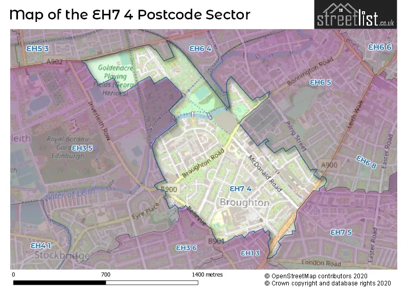
| The EH7 4 Sector is within these Local Authorities | |
|---|---|
| The EH7 4 Sector is within these Counties | |
| The EH7 4 Sector is within these Water Company Areas |