Given that each sector allows for 400 unique postcode combinations. Letters C, I, K, M, O and V are not allowed in the last two letters of a postcode. With 274 postcodes already in use, this leaves 126 units available.
The EH7 6 postal code covers the settlement of EDINBURGH.
The EH7 6 Postcode shares a border with EH8 8 (EDINBURGH), EH6 8 (EDINBURGH), EH6 7 (EDINBURGH), EH8 7 (EDINBURGH), EH7 5 (EDINBURGH) and EH15 1 (EDINBURGH).
The sector is within the post town of EDINBURGH.
EH7 6 is a postcode sector within the EH7 postcode district which is within the EH Edinburgh postcode area.
The Royal Mail delivery office for the EH7 6 postal sector is the Edinburgh East Central Delivery Office.
The area of the EH7 6 postcode sector is 1.01 square miles which is 2.62 square kilometres or 646.52 square acres.

Map of the EH7 6 Postcode Sector
Explore the EH7 6 postcode sector by using our free interactive map.
| E | H | 7 | - | 6 | X | X |
| E | H | 7 | Space | 6 | Letter | Letter |
Official List of Streets
EDINBURGH (91 Streets)
Unofficial Streets or Alternative Spellings
EDINBURGH
BAILEYFIELD ROAD CLOCKMILL LANE DALGETY ROAD DALGETY STREET LATTA PLACE LOCHEND BUTTERFLY WAY LOWER LONDON ROAD MEADOWBANK MEADOWBANK TERRACE PARSONS GREEN TERRACE PORTOBELLO ROAD SEAFIELD STREET SIR HARRY LAUDER ROAD WEST KILNACRE WILLOWBRAE ROAD BRYCE GROVE FISHWIVES CAUSEWAY GUMLEY PLACE PARKER ROAD RESTALRIG RAILWAY PATH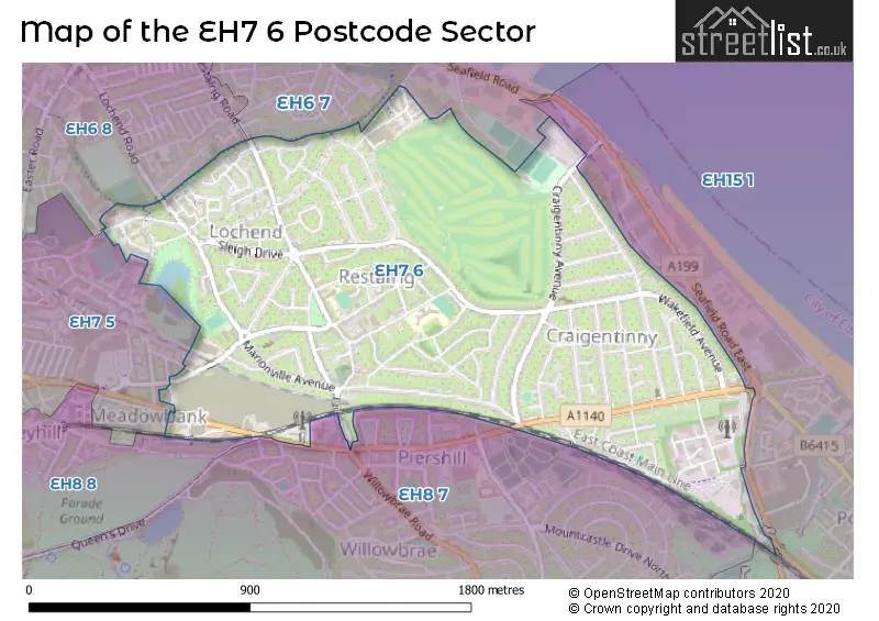
| The EH7 6 Sector is within these Local Authorities | |
|---|---|
| The EH7 6 Sector is within these Counties | |
| The EH7 6 Sector is within these Water Company Areas |