Given that each sector allows for 400 unique postcode combinations. Letters C, I, K, M, O and V are not allowed in the last two letters of a postcode. With 235 postcodes already in use, this leaves 165 units available.
The FK8 1 postal code covers the settlement of STIRLING.
The FK8 1 Postcode shares a border with FK7 7 (STIRLING, Fallin, Cowie), FK8 2 (STIRLING), FK8 3 (Kippen, Aberfoyle, Thornhill), FK9 4 (Bridge Of Allan, STIRLING, Blairdrummond) and FK9 5 (STIRLING, Blairlogie).
The sector is within the post town of STIRLING.
FK8 1 is a postcode sector within the FK8 postcode district which is within the FK Falkirk postcode area.
The Royal Mail delivery office for the FK8 1 postal sector is the Stirling Delivery Office.
The area of the FK8 1 postcode sector is 1.03 square miles which is 2.66 square kilometres or 656.78 square acres.


Map of the FK8 1 Postcode Sector
Explore the FK8 1 postcode sector by using our free interactive map.
| F | K | 8 | - | 1 | X | X |
| F | K | 8 | Space | 1 | Letter | Letter |
Official List of Streets
STIRLING (145 Streets)
Unofficial Streets or Alternative Spellings
STIRLING
BURGHMUIR ROAD CAUSEWAYHEAD ROAD CLARENDON ROAD GREENWOOD AVENUE PLAYERS ROAD PORT STREET STATION ROAD ACADEMY ROAD BACK O HILL ROUNDABOUT BACK OHILL ROAD BACK WALK BALLENGEICH PASS BALLENGEICH ROUNDABOUT CAMBUSKENNETH BRIDGE CRAIGHALL COURT CUSTOMS ROUNDABOUT DALGLEISH COURT DUMBARTON ROAD FORTH TRAIL FORTH VIEW FORTHSIDE BRIDGE FRIAR STREET KINGSTABLES LANE LAURENCECROFT MILLENNIUM WAY OHANLON WAY SEAFORTH PLACE SHORE ROAD SNOWDON STIRLING BRIDGE VALLEY LANE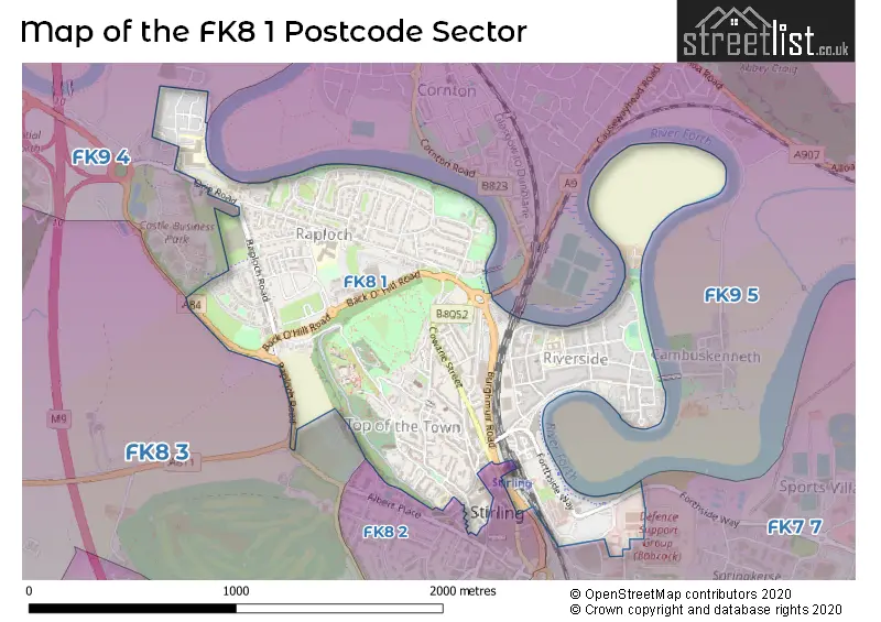
| The FK8 1 Sector is within these Local Authorities | |
|---|---|
| The FK8 1 Sector is within these Counties | |
| The FK8 1 Sector is within these Water Company Areas |