The HD5 9 postcode sector is within the county of West Yorkshire.
Did you know? According to the 2021 Census, the HD5 9 postcode sector is home to a bustling 11,701 residents!
Given that each sector allows for 400 unique postcode combinations. Letters C, I, K, M, O and V are not allowed in the last two letters of a postcode. With 255 postcodes already in use, this leaves 145 units available.
The largest settlements in the HD5 9 postal code are HUDDERSFIELD and Moldgreen.
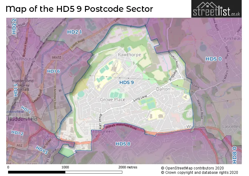
The HD5 9 Postcode shares a border with HD4 6 (HUDDERSFIELD, Thurstonland, Newsome), HD1 6 (HUDDERSFIELD, Hillhouse), HD1 3 (HUDDERSFIELD, Lockwood, Thornton Lodge), HD2 1 (HUDDERSFIELD, Bradley, Fartown), HD5 0 (HUDDERSFIELD, Kirkheaton, Tandem) and HD5 8 (HUDDERSFIELD, Almondbury, Waterloo).
The sector is within the post town of HUDDERSFIELD.
HD5 9 is a postcode sector within the HD5 postcode district which is within the HD Huddersfield postcode area.
The Royal Mail delivery office for the HD5 9 postal sector is the Huddersfield Delivery Office.
The area of the HD5 9 postcode sector is 1.28 square miles which is 3.32 square kilometres or 820.55 square acres.
Waterways within the HD5 9 postcode sector include the River Holme.

Map of the HD5 9 Postcode Sector
Explore the HD5 9 postcode sector by using our free interactive map.
| H | D | 5 | - | 9 | X | X |
| H | D | 5 | Space | 9 | Letter | Letter |
Official List of Streets
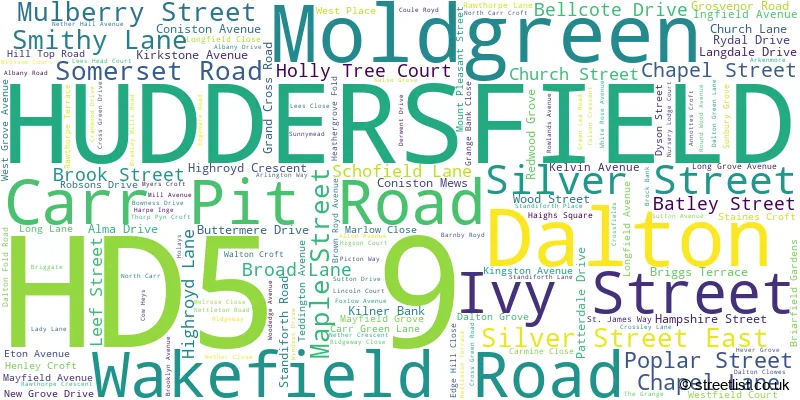
HUDDERSFIELD (128 Streets)
Dalton (1 Streets)
Moldgreen (13 Streets)
Unofficial Streets or Alternative Spellings
HUDDERSFIELD
DOG KENNEL BANK FLEMINGHOUSE LANE OLD WAKEFIELD ROAD SILVER STREET EAST ASPLEY HEIGHTS BACK CHAPEL LANE COLD ROYD LANE FIRST AVENUE HEYS VIEW KINGS MILL LANE MOUNT ZION ROAD OXFIELD COURT RIVERSIDE WAY ROOKERY ROAD SECOND AVENUE SILVER STREET WEST SOMERSET BRIDGE ST ANDREWS ROADAlmondbury
SOMERSET ROADFenay Bridge
WAKEFIELD ROADWeather Forecast for HD5 9
Press Button to Show Forecast for Huddersfield
| Time Period | Icon | Description | Temperature | Rain Probability | Wind |
|---|---|---|---|---|---|
| 03:00 to 06:00 | Cloudy | 9.0°C (feels like 9.0°C) | 6.00% | ENE 2 mph | |
| 06:00 to 09:00 | Cloudy | 10.0°C (feels like 10.0°C) | 15.00% | ENE 2 mph | |
| 09:00 to 12:00 | Overcast | 12.0°C (feels like 11.0°C) | 13.00% | ENE 4 mph | |
| 12:00 to 15:00 | Overcast | 14.0°C (feels like 13.0°C) | 21.00% | NE 4 mph | |
| 15:00 to 18:00 | Light rain | 15.0°C (feels like 14.0°C) | 49.00% | NE 7 mph | |
| 18:00 to 21:00 | Cloudy | 14.0°C (feels like 13.0°C) | 13.00% | NE 7 mph | |
| 21:00 to 00:00 | Overcast | 11.0°C (feels like 10.0°C) | 10.00% | NNE 9 mph |
Press Button to Show Forecast for Huddersfield
| Time Period | Icon | Description | Temperature | Rain Probability | Wind |
|---|---|---|---|---|---|
| 00:00 to 03:00 | Overcast | 9.0°C (feels like 7.0°C) | 10.00% | NNE 9 mph | |
| 03:00 to 06:00 | Overcast | 9.0°C (feels like 8.0°C) | 10.00% | NNE 9 mph | |
| 06:00 to 09:00 | Overcast | 10.0°C (feels like 8.0°C) | 9.00% | NNE 11 mph | |
| 09:00 to 12:00 | Cloudy | 13.0°C (feels like 11.0°C) | 4.00% | NE 13 mph | |
| 12:00 to 15:00 | Partly cloudy (day) | 16.0°C (feels like 14.0°C) | 1.00% | NE 13 mph | |
| 15:00 to 18:00 | Partly cloudy (day) | 16.0°C (feels like 14.0°C) | 1.00% | NE 13 mph | |
| 18:00 to 21:00 | Cloudy | 13.0°C (feels like 11.0°C) | 4.00% | NE 11 mph | |
| 21:00 to 00:00 | Overcast | 11.0°C (feels like 8.0°C) | 8.00% | NNE 11 mph |
Press Button to Show Forecast for Huddersfield
| Time Period | Icon | Description | Temperature | Rain Probability | Wind |
|---|---|---|---|---|---|
| 00:00 to 03:00 | Overcast | 10.0°C (feels like 8.0°C) | 9.00% | NNE 9 mph | |
| 03:00 to 06:00 | Overcast | 10.0°C (feels like 8.0°C) | 12.00% | N 7 mph | |
| 06:00 to 09:00 | Cloudy | 10.0°C (feels like 9.0°C) | 14.00% | N 7 mph | |
| 09:00 to 12:00 | Overcast | 12.0°C (feels like 11.0°C) | 17.00% | N 9 mph | |
| 12:00 to 15:00 | Cloudy | 15.0°C (feels like 13.0°C) | 15.00% | N 9 mph | |
| 15:00 to 18:00 | Cloudy | 16.0°C (feels like 15.0°C) | 13.00% | N 9 mph | |
| 18:00 to 21:00 | Cloudy | 14.0°C (feels like 13.0°C) | 13.00% | NNW 9 mph | |
| 21:00 to 00:00 | Overcast | 12.0°C (feels like 10.0°C) | 15.00% | WNW 7 mph |
Press Button to Show Forecast for Huddersfield
| Time Period | Icon | Description | Temperature | Rain Probability | Wind |
|---|---|---|---|---|---|
| 00:00 to 03:00 | Overcast | 11.0°C (feels like 9.0°C) | 13.00% | WNW 7 mph | |
| 03:00 to 06:00 | Overcast | 10.0°C (feels like 9.0°C) | 13.00% | WNW 7 mph | |
| 06:00 to 09:00 | Overcast | 10.0°C (feels like 9.0°C) | 11.00% | W 4 mph | |
| 09:00 to 12:00 | Cloudy | 12.0°C (feels like 11.0°C) | 11.00% | WSW 7 mph | |
| 12:00 to 15:00 | Cloudy | 15.0°C (feels like 14.0°C) | 9.00% | SW 7 mph | |
| 15:00 to 18:00 | Cloudy | 16.0°C (feels like 15.0°C) | 12.00% | WSW 7 mph | |
| 18:00 to 21:00 | Partly cloudy (day) | 16.0°C (feels like 14.0°C) | 9.00% | SW 7 mph | |
| 21:00 to 00:00 | Partly cloudy (night) | 13.0°C (feels like 12.0°C) | 5.00% | SW 7 mph |
Schools and Places of Education Within the HD5 9 Postcode Sector
Dalton School
Community school
Mayfield Avenue, Huddersfield, West Yorkshire, HD5 9HN
Head: Mr Ian Richardson
Ofsted Rating: Good
Inspection: 2021-10-14 (930 days ago)
Website: Visit Dalton School Website
Phone: 01484538729
Number of Pupils: 521
Netherhall Learning Campus High School
Community school
Netherhall Avenue, Huddersfield, West Yorkshire, HD5 9PG
Head: Mr Michael Kent
Ofsted Rating: Requires improvement
Inspection: 2022-05-18 (714 days ago)
Website: Visit Netherhall Learning Campus High School Website
Phone: 01484382140
Number of Pupils: 810
Netherhall Learning Campus Junior School
Community school
Rawthorpe Lane, Huddersfield, West Yorkshire, HD5 9NT
Head: Mrs Zoe Lowe
Ofsted Rating: Good
Inspection: 2023-09-20 (224 days ago)
Website: Visit Netherhall Learning Campus Junior School Website
Phone: 01484300080
Number of Pupils: 300
Netherhall St James CofE (VC) Infant and Nursery School
Voluntary controlled school
Rawthorpe Lane, Huddersfield, West Yorkshire, HD5 9NT
Head: Mrs Kirsty McGrath
Ofsted Rating: Good
Inspection: 2023-06-21 (315 days ago)
Website: Visit Netherhall St James CofE (VC) Infant and Nursery School Website
Phone: 01484226601
Number of Pupils: 215
House Prices in the HD5 9 Postcode Sector
| Type of Property | 2018 Average | 2018 Sales | 2017 Average | 2017 Sales | 2016 Average | 2016 Sales | 2015 Average | 2015 Sales |
|---|---|---|---|---|---|---|---|---|
| Detached | £189,769 | 13 | £205,214 | 14 | £195,788 | 12 | £212,857 | 14 |
| Semi-Detached | £124,091 | 71 | £123,306 | 56 | £116,245 | 71 | £109,093 | 68 |
| Terraced | £111,500 | 63 | £90,301 | 71 | £89,412 | 50 | £97,154 | 58 |
| Flats | £62,000 | 1 | £113,333 | 3 | £79,000 | 5 | £75,500 | 4 |
Important Postcodes HD5 9 in the Postcode Sector
HD5 9AA is the postcode for Kirklees Metropolitan Council, Riverbank Court, Wakefield Road
HD5 9HN is the postcode for Dalton Junior Infant & Nursery School, Mayfield Avenue
HD5 9HU is the postcode for St. Josephs Catholic Primary School, Grosvenor Road
HD5 9NT is the postcode for Rawthorpe St James CE (VC) I & N School, Rawthorpe Lane, Netherhall St James CE(VC) Infant & Nursery School, Nursery School, Rawthorpe Lane, Netherhall St James CE(VC) Infant & Nursery School, Rawthorpe Lane, Rawthorpe Junior School, Rawthorpe Lane, and NETHERHALL LEARNING CAMPUS JUNIOR SCHOOL, RAWTHORPE LANE, RAWTHORPE
HD5 9PG is the postcode for Nether Hall Learning Campus High School, Netherhall Avenue, and Rawthorpe High School, Netherhall Avenue
HD5 9QJ is the postcode for DRAM Sport and Community Centre, Ridgeway
HD5 9TS is the postcode for Mill Hill Community Health Centre, 86 Dalton Green Lane
HD5 9XP is the postcode for The Waterloo Practice, 613-615 Wakefield Road
| The HD5 9 Sector is within these Local Authorities |
|
|---|---|
| The HD5 9 Sector is within these Counties |
|
| The HD5 9 Sector is within these Water Company Areas |
|