The HR4 0 postcode sector is within the county of Herefordshire.
Did you know? According to the 2021 Census, the HR4 0 postcode sector is home to a bustling 11,304 residents!
Given that each sector allows for 400 unique postcode combinations. Letters C, I, K, M, O and V are not allowed in the last two letters of a postcode. With 242 postcodes already in use, this leaves 158 units available.
The HR4 0 postal code covers the settlement of HEREFORD.
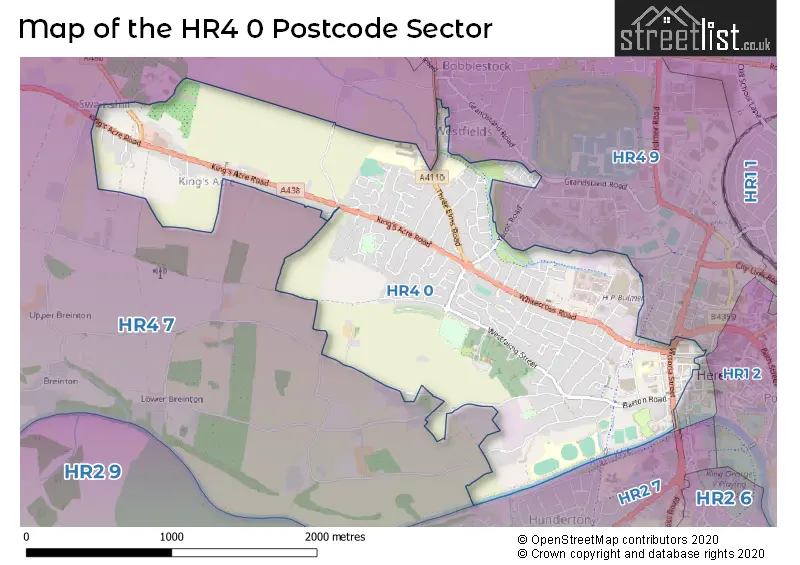
The HR4 0 Postcode shares a border with HR2 7 (HEREFORD, Belmont), HR4 7 (Credenhill, Burghill, Staunton-on-Wye) and HR4 9 (HEREFORD, Holmer).
The sector is within the post town of HEREFORD.
HR4 0 is a postcode sector within the HR4 postcode district which is within the HR Hereford postcode area.
The Royal Mail delivery office for the HR4 0 postal sector is the Hereford Delivery Office.
The area of the HR4 0 postcode sector is 1.97 square miles which is 5.10 square kilometres or 1,259.39 square acres.
The HR4 0 postcode sector is crossed by the A49 Major A road.
Waterways within the HR4 0 postcode sector include the River Wye.

Map of the HR4 0 Postcode Sector
Explore the HR4 0 postcode sector by using our free interactive map.
| H | R | 4 | - | 0 | X | X |
| H | R | 4 | Space | 0 | Letter | Letter |
Official List of Streets
HEREFORD (142 Streets)
Unofficial Streets or Alternative Spellings
HEREFORD
GRANDSTAND ROAD PORTLAND STREET ALL SAINTS STREET BAKERS LANE CHURCH WALK CROSSWAYS EASTERN AVENUE EDGAR STREET ROUNDABOUT FAYRE OAKES DRIVE FAYRE OAKES GREEN GREAT WESTERN WAY GRIMMER ROAD GUNNERS LANE MIDDLEWAY MINI ROUNDABOUT WESTERN AVENUE WHITE CROSS ROAD WHITE HORSE COURTStretton Sugwas
WYEVALE WAYSchools and Places of Education Within the HR4 0 Postcode Sector
Lord Scudamore Primary Academy
Academy converter
Friar Street, Hereford, Herefordshire, HR4 0AS
Head: Mrs Alison Taylor
Ofsted Rating: Good
Inspection: 2023-02-03 (480 days ago)
Website: Visit Lord Scudamore Primary Academy Website
Phone: 01432273951
Number of Pupils: 587
Trinity Primary School
Community school
Barricombe Drive, Hereford, Herefordshire, HR4 0NU
Head: Mrs Lyndsey Manning
Ofsted Rating: Good
Inspection: 2023-12-07 (173 days ago)
Website: Visit Trinity Primary School Website
Phone: 01432266268
Number of Pupils: 571
Whitecross Hereford
Academy converter
Three Elms Road, Hereford, Herefordshire, HR4 0RN
Head: Mr Timothy Knapp
Ofsted Rating: Good
Inspection: 2023-06-08 (355 days ago)
Website: Visit Whitecross Hereford Website
Phone: 01432376080
Number of Pupils: 940
House Prices in the HR4 0 Postcode Sector
| Type of Property | 2018 Average | 2018 Sales | 2017 Average | 2017 Sales | 2016 Average | 2016 Sales | 2015 Average | 2015 Sales |
|---|---|---|---|---|---|---|---|---|
| Detached | £302,256 | 50 | £304,791 | 65 | £275,216 | 34 | £282,523 | 37 |
| Semi-Detached | £217,462 | 60 | £213,076 | 91 | £204,851 | 61 | £228,613 | 57 |
| Terraced | £198,826 | 72 | £170,036 | 81 | £175,991 | 82 | £175,293 | 84 |
| Flats | £166,854 | 24 | £172,579 | 42 | £127,291 | 24 | £110,658 | 25 |
Important Postcodes HR4 0 in the Postcode Sector
HR4 0AS is the postcode for Lord Scudamore Primary School, Friars Street, and Museum Resource & Learning Centre, 58 Friars Street
HR4 0BH is the postcode for Greyfriars Surgery, 25 St. Nicholas Street
HR4 0BJ is the postcode for 44 Berrington Street
HR4 0DD is the postcode for Jobcentre Plus, 6 St. Nicholas Street
HR4 0DG is the postcode for Herefordshire College of Arts, Higher Education Centre, Whitecross Road
HR4 0JE is the postcode for Hereford Crematorium, Westfaling Street
HR4 0JF is the postcode for Quay House Medical Centre, 100 Westfaling Street
HR4 0LE is the postcode for Herefordshire District Council, The Cider Mills, Plough Lane
HR4 0NU is the postcode for TRINITY PRIMARY SCHOOL, Barricombe Drive, Aspen House, Barricombe Drive, and SWIMMING POOL, Aspen House, Barricombe Drive
HR4 0RN is the postcode for Whitecross High School, Three Elms Road
HR4 0XH is the postcode for Herefordshire Council
| The HR4 0 Sector is within these Local Authorities |
|
|---|---|
| The HR4 0 Sector is within these Counties |
|
| The HR4 0 Sector is within these Water Company Areas |
|