The HS2 postcode district is a postal district located in the HS Outer Hebrides postcode area with a population of 14,329 residents according to the 2011 Scotland Census.
The area of the HS2 postcode district is 66.25 square miles which is 171.57 square kilometres or 42,396.77 acres.
Currently, the HS2 district has about 360 postcode units spread across 2 geographic postcode sectors.
Given that each sector allows for 400 unique postcode combinations, the district has a capacity of 800 postcodes. With 360 postcodes already in use, this leaves 440 units available.
The largest settlement in the HS2 postal code is Newmarket followed by Sandwick, and Point.
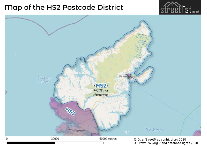
The postcode area has a boundary with Sea of the Hebredes and The Minch and The North Atlantic Ocean.
The HS2 Postcode shares a border with HS3 (Tarbert, ISLE OF HARRIS, Rhenigidale).
In the HS2 postcode district, the primary settlement is Isle of Lewis, located in the Western Isles. The most significant postal town is also Isle of Lewis. Other significant settlements in the district include Aignish, Back, Barvas, Borve, Coll, Cross, Holm, Laxdale, Lionel, Marybank, Newmarket, Point, Sandwick, Tong, and Vatisker. These settlements are also located in the Western Isles.
For the district HS2, we have data on 2 postcode sectors. Here's a breakdown:

Map of the HS2 Postcode District
Explore the HS2 postcode district by using our free interactive map.
When it comes to local government, postal geography often disregards political borders. However, for a breakdown in the HS2 District: the district mostly encompasses the Na h-Eileanan an Iar area with a total of 362 postcodes.
Weather Forecast for HS2
Press Button to Show Forecast for Kershader Youth Hostel
| Time Period | Icon | Description | Temperature | Rain Probability | Wind |
|---|---|---|---|---|---|
| 00:00 to 03:00 | Cloudy | 5.0°C (feels like 3.0°C) | 10.00% | NNW 7 mph | |
| 03:00 to 06:00 | Cloudy | 4.0°C (feels like 3.0°C) | 8.00% | WNW 4 mph | |
| 06:00 to 09:00 | Cloudy | 5.0°C (feels like 4.0°C) | 7.00% | NW 4 mph | |
| 09:00 to 12:00 | Cloudy | 6.0°C (feels like 5.0°C) | 16.00% | NNW 2 mph | |
| 12:00 to 15:00 | Light rain shower (day) | 7.0°C (feels like 5.0°C) | 46.00% | S 7 mph | |
| 15:00 to 18:00 | Light rain shower (day) | 7.0°C (feels like 6.0°C) | 45.00% | SW 4 mph | |
| 18:00 to 21:00 | Light rain | 7.0°C (feels like 5.0°C) | 47.00% | S 4 mph | |
| 21:00 to 00:00 | Cloudy | 5.0°C (feels like 4.0°C) | 6.00% | ESE 2 mph |
Press Button to Show Forecast for Kershader Youth Hostel
| Time Period | Icon | Description | Temperature | Rain Probability | Wind |
|---|---|---|---|---|---|
| 00:00 to 03:00 | Partly cloudy (night) | 4.0°C (feels like 2.0°C) | 1.00% | SE 2 mph | |
| 03:00 to 06:00 | Partly cloudy (night) | 4.0°C (feels like 2.0°C) | 2.00% | SE 4 mph | |
| 06:00 to 09:00 | Cloudy | 5.0°C (feels like 4.0°C) | 5.00% | ESE 4 mph | |
| 09:00 to 12:00 | Partly cloudy (day) | 8.0°C (feels like 6.0°C) | 4.00% | SE 7 mph | |
| 12:00 to 15:00 | Cloudy | 9.0°C (feels like 7.0°C) | 10.00% | SE 7 mph | |
| 15:00 to 18:00 | Cloudy | 9.0°C (feels like 8.0°C) | 12.00% | ENE 7 mph | |
| 18:00 to 21:00 | Partly cloudy (day) | 8.0°C (feels like 7.0°C) | 10.00% | N 7 mph | |
| 21:00 to 00:00 | Clear night | 6.0°C (feels like 4.0°C) | 5.00% | N 7 mph |
Press Button to Show Forecast for Kershader Youth Hostel
| Time Period | Icon | Description | Temperature | Rain Probability | Wind |
|---|---|---|---|---|---|
| 00:00 to 03:00 | Partly cloudy (night) | 5.0°C (feels like 3.0°C) | 6.00% | S 7 mph | |
| 03:00 to 06:00 | Partly cloudy (night) | 5.0°C (feels like 2.0°C) | 8.00% | S 7 mph | |
| 06:00 to 09:00 | Partly cloudy (day) | 6.0°C (feels like 4.0°C) | 14.00% | SSE 9 mph | |
| 09:00 to 12:00 | Cloudy | 9.0°C (feels like 6.0°C) | 22.00% | SSE 13 mph | |
| 12:00 to 15:00 | Light rain | 10.0°C (feels like 7.0°C) | 51.00% | SSE 13 mph | |
| 15:00 to 18:00 | Light rain | 10.0°C (feels like 7.0°C) | 51.00% | SE 13 mph | |
| 18:00 to 21:00 | Heavy rain | 10.0°C (feels like 7.0°C) | 71.00% | SE 13 mph | |
| 21:00 to 00:00 | Heavy rain | 9.0°C (feels like 6.0°C) | 71.00% | SE 13 mph |
Press Button to Show Forecast for Kershader Youth Hostel
| Time Period | Icon | Description | Temperature | Rain Probability | Wind |
|---|---|---|---|---|---|
| 00:00 to 03:00 | Light rain | 9.0°C (feels like 6.0°C) | 45.00% | SE 11 mph | |
| 03:00 to 06:00 | Cloudy | 8.0°C (feels like 6.0°C) | 12.00% | ESE 11 mph | |
| 06:00 to 09:00 | Cloudy | 9.0°C (feels like 6.0°C) | 12.00% | ESE 11 mph | |
| 09:00 to 12:00 | Cloudy | 11.0°C (feels like 8.0°C) | 10.00% | ESE 11 mph | |
| 12:00 to 15:00 | Partly cloudy (day) | 12.0°C (feels like 10.0°C) | 5.00% | ESE 11 mph | |
| 15:00 to 18:00 | Cloudy | 13.0°C (feels like 11.0°C) | 7.00% | ESE 11 mph | |
| 18:00 to 21:00 | Partly cloudy (day) | 12.0°C (feels like 10.0°C) | 4.00% | NNE 11 mph | |
| 21:00 to 00:00 | Clear night | 10.0°C (feels like 8.0°C) | 3.00% | E 11 mph |
Where is the HS2 Postcode District?
The HS2 postcode district is located in the Isle of Lewis, specifically in the town of Isle of Lewis. It is situated nearby several towns, such as Stornoway to the East (8.24 miles away), Isle of Harris to the South West (22.54 miles away), Isle of Scalpay to the South (22.90 miles away), and Gairloch to the South East (45.78 miles away). Additionally, the district is approximately 529.1 miles away from the center of London.
The district is within the post town of ISLE OF LEWIS.
The sector has postcodes within the nation of Scotland.
The HS2 Postcode District is in the Na h-Eileanan Siar (Western Isles) region of Highlands and Islands within the Scotland.
Postcode Districts that Share a Border with HS2
| Postcode Sector | Delivery Office |
|---|---|
| HS2 0 | Stornoway Delivery Office |
| HS2 0 | Barvas Scale Payment Delivery Office |
| HS2 0 | Ness Scale Payment Delivery Office |
| HS2 0 | Port Of Ness Scale Payment Delivery Office |
| HS2 9 | Stornoway Delivery Office |
| HS2 9 | Barvas Scale Payment Delivery Office |
| HS2 9 | Bernera Scale Payment Delivery Office |
| HS2 9 | Callanish Scale Payment Delivery Office |
| HS2 9 | Gravir Scale Payment Delivery Office |
| HS2 9 | Shawbost Scale Payment Delivery Office |
| HS2 9 | Balallan Scale Payment Delivery Office |
| HS2 9 | Timsgarry Scale Payment Delivery Office |
| H | S | 2 | - | X | X | X |
| H | S | 2 | Space | Numeric | Letter | Letter |
Current Monthly Rental Prices
| # Bedrooms | Min Price | Max Price | Avg Price |
|---|
Current House Prices
| # Bedrooms | Min Price | Max Price | Avg Price |
|---|---|---|---|
| £34,995 | £69,000 | £52,998 | |
| 2 | £300,000 | £300,000 | £300,000 |
| 3 | £165,000 | £195,000 | £180,000 |
| 4 | £200,000 | £450,000 | £286,667 |
Estate Agents who Operate in the HS2 District
| Logo | Name | Brand Name | Address | Contact Number | Total Properties |
|---|---|---|---|---|---|
 | Edinburgh | McEwan Fraser Legal | Claremont House 130 East Claremont Street Edinburgh EH7 4LB | 0131 381 4292 | 3 |
 | Carlisle | C & D Rural | Lakeside, Townfoot, Longtown, Carlisle, CA6 5LY | 01228 279009 | 2 |
 | Beauly | Bell Ingram | 5 High Street Beauly IV4 7BS | 01463 211703 | 2 |
 | Alloa | County Estates | 16-18 Mar Street, Alloa, FK10 1HR | 01259 235874 | 1 |
 | Nationwide | Express Estate Agency | St Georges House, 56 Peter St, Manchester M2 3NQ | 03330 165458 | 1 |
- Aird
- Aird Tong / �ird Thunga
- Bac
- Baile Ailein
- Barvas
- Bragar
- Breascleit / Breasclete
- Calanais / Callanish
- Carloway / C�rlabhagh
- Col
- Col Uarach
- Cros
- Crosbost
- Dail bho Dheas
- E�radal / Eorodale
- Garrabost
- Gravir / Grabhair
- Knock
- Lacasaidh
- L�onal
- Liurbost
- Lower Bayble
- Melbost / Mealabost
- Na Gearrannan
- Nis / Ness
- Pabail Uarach
- Portvoller
- Sanndabhaig
- Sgiogarstaigh
- Shader
- Shawbost
- Ste�rnabhagh
- Sulaisiadar
- Tarbert
- Timsgearraidh
- Tolastadh bho Thuath
- Tong