The HU4 6 postcode sector is within the county of East Riding of Yorkshire.
Did you know? According to the 2021 Census, the HU4 6 postcode sector is home to a bustling 13,764 residents!
Given that each sector allows for 400 unique postcode combinations. Letters C, I, K, M, O and V are not allowed in the last two letters of a postcode. With 242 postcodes already in use, this leaves 158 units available.
The largest settlements in the HU4 6 postal code are HULL and Gipsyville.
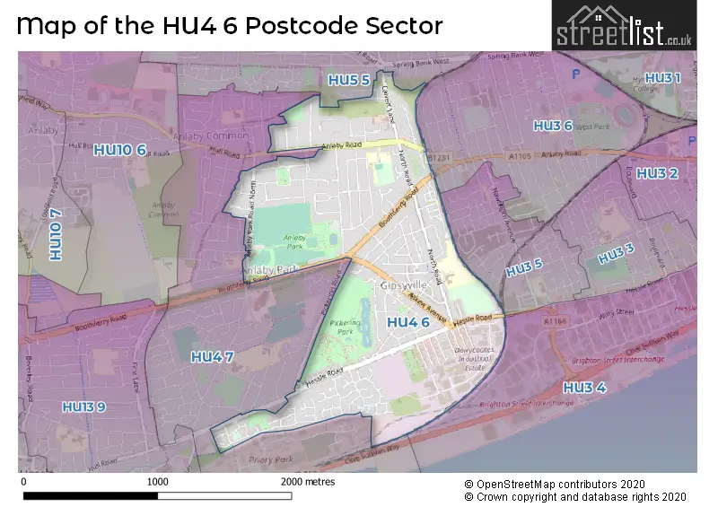
The HU4 6 Postcode shares a border with HU3 6 (HULL), HU4 7 (HULL, Anlaby Common), HU3 4 (HULL, Brighton Street Industrial Estate), HU3 5 (HULL) and HU5 5 (HULL).
The sector is within the post town of HULL.
HU4 6 is a postcode sector within the HU4 postcode district which is within the HU Hull postcode area.
The Royal Mail delivery office for the HU4 6 postal sector is the Hull City Delivery Office.
The area of the HU4 6 postcode sector is 1.30 square miles which is 3.37 square kilometres or 833.49 square acres.

Map of the HU4 6 Postcode Sector
Explore the HU4 6 postcode sector by using our free interactive map.
| H | U | 4 | - | 6 | X | X |
| H | U | 4 | Space | 6 | Letter | Letter |
Official List of Streets
HULL (107 Streets)
Anlaby Park (1 Streets)
Unofficial Streets or Alternative Spellings
HULL
ANLABY PARK ROAD SOUTH KENDAL WAY ROKEBY AVENUE SIBELIUS ROAD TILBURY ROAD ACCESS ROAD BLACK AND AMBER WAY CROSSFIELD ROAD DAIRYCOATES ROAD DERWENT AVENUE FALCON COURT FIVEWAYS FLEMING WALK GRAHAM AVENUE KIPLING WALK MARLBOROUGH AVENUE OLIVIER COURT PARK AVENUE PICKERING PARK PICKERING VIEW PLANTATION DRIVE ST BEDES COURT TENFOOT THE AVENUE WESTBOURNE AVENUE WHITEDALEHESSLE,
BOOTHFERRY ROAD HESSLE ROADBrighton Street Industrial Estate
FREIGHTLINER ROADSchools and Places of Education Within the HU4 6 Postcode Sector
Eastfield Primary School
Academy converter
791 Anlaby Road, Hull, , HU4 6BB
Head: Mrs Karen Barkworth
Ofsted Rating: Outstanding
Inspection: 2015-06-18 (3275 days ago)
Website: Visit Eastfield Primary School Website
Phone: 01482351150
Number of Pupils: 618
Francis Askew Primary School
Academy converter
North Road, Hull, , HU4 6LQ
Head: Mrs Laura Martin
Ofsted Rating: Good
Inspection: 2023-04-26 (406 days ago)
Website: Visit Francis Askew Primary School Website
Phone: 01482509627
Number of Pupils: 415
House Prices in the HU4 6 Postcode Sector
| Type of Property | 2018 Average | 2018 Sales | 2017 Average | 2017 Sales | 2016 Average | 2016 Sales | 2015 Average | 2015 Sales |
|---|---|---|---|---|---|---|---|---|
| Detached | £177,975 | 22 | £190,641 | 22 | £188,856 | 24 | £188,234 | 36 |
| Semi-Detached | £149,629 | 75 | £141,292 | 89 | £138,296 | 84 | £140,118 | 104 |
| Terraced | £108,290 | 101 | £100,772 | 86 | £106,075 | 93 | £108,357 | 138 |
| Flats | £78,650 | 13 | £85,493 | 9 | £71,071 | 7 | £91,400 | 8 |
Important Postcodes HU4 6 in the Postcode Sector
HU4 6BH is the postcode for The Calvert Practice, 110a Calvert Lane, and THE CALVERT CENTRE, 110A CALVERT LANE
HU4 6BL is the postcode for Humberside Fire & Rescue Service, Fire Station, Calvert Lane
HU4 6BS is the postcode for West Hull Long Term Support Centre, Lindsey Place
HU4 6DT is the postcode for Eastfield Adult Education Centre, Eastfield Road, and Eastfield Primary School, Eastfield Road
HU4 6LQ is the postcode for Francis Askew Primary School, North Road
HU4 6RF is the postcode for The Oaks Medical Centre, Council Avenue
HU4 6TE is the postcode for Humberside Police, Pickering Road
HU4 6XQ is the postcode for Costello Sports Stadium, Anlaby Park Road North
| The HU4 6 Sector is within these Local Authorities |
|
|---|---|
| The HU4 6 Sector is within these Counties |
|
| The HU4 6 Sector is within these Water Company Areas |
|