The LS22 5 postcode sector stands on the North Yorkshire and West Yorkshire border.
Did you know? According to the 2021 Census, the LS22 5 postcode sector is home to a bustling 3,857 residents!
Given that each sector allows for 400 unique postcode combinations. Letters C, I, K, M, O and V are not allowed in the last two letters of a postcode. With 152 postcodes already in use, this leaves 248 units available.
The largest settlement in the LS22 5 postal code is Collingham followed by WETHERBY, and Bickerton.
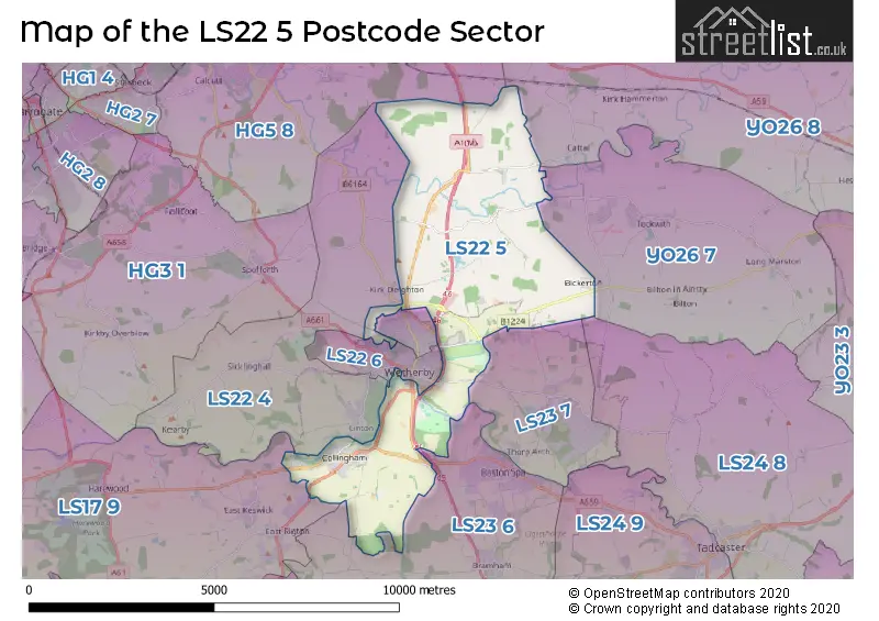
The LS22 5 Postcode shares a border with LS22 4 (Linton, Sicklinghall, Kirk Deighton), LS23 6 (Boston Spa, Bramham, Clifford), LS23 7 (Thorp Arch, Thorp Arch Estate, Walton), LS24 8 (TADCASTER, Healaugh, Colton), YO26 7 (Tockwith, Long Marston, Bilton-in-Ainsty), YO26 8 (Green Hammerton, Whixley, Kirk Hammerton), HG5 8 (KNARESBOROUGH, Goldsborough, Plompton), LS22 6 (WETHERBY), LS22 7 (WETHERBY) and LS17 9 (Bardsey, Harewood, East Keswick).
The sector is within the post town of WETHERBY.
LS22 5 is a postcode sector within the LS22 postcode district which is within the LS Leeds postcode area.
The Royal Mail delivery office for the LS22 5 postal sector is the Wetherby Delivery Office.
The area of the LS22 5 postcode sector is 15.23 square miles which is 39.44 square kilometres or 9,746.36 square acres.
The LS22 5 postcode sector is crossed by the A1M Major A road.
Waterways within the LS22 5 postcode sector include the River Wharfe, River Crimple, River Nidd, Collingham Beck.

Map of the LS22 5 Postcode Sector
Explore the LS22 5 postcode sector by using our free interactive map.
| L | S | 2 | 2 | - | 5 | X | X |
| L | S | 2 | 2 | Space | 5 | Letter | Letter |
Official List of Streets
WETHERBY (26 Streets)
Hunsingore (7 Streets)
Collingham (55 Streets)
Kirk Deighton (3 Streets)
North Deighton (2 Streets)
Bickerton (8 Streets)
Unofficial Streets or Alternative Spellings
WETHERBY
ASHBURN WAY BLOOM DRIVE DEIGHTON ROAD EZART AVENUE GLEBE FIELD DRIVE GREAT NORTH CLOSE HIGH STREET MONTAGU CRESCENT PENTAGON WAY QUARRY HILL LANECollingham
LANGWITH TERRACEKirk Deighton
ASHDALE LANE MARK LANE SCRIFTAIN LANE WETHERBY ROADBardsey
WETHERBY ROADSchools and Places of Education Within the LS22 5 Postcode Sector
Collingham Lady Elizabeth Hastings Church of England Voluntary Aided Primary School
Voluntary aided school
Linton Road, Wetherby, West Yorkshire, LS22 5BS
Head: Mr Paul Cook
Ofsted Rating: Good
Inspection: 2021-11-24 (911 days ago)
Website: Visit Collingham Lady Elizabeth Hastings Church of England Voluntary Aided Primary School Website
Phone: 01937573117
Number of Pupils: 208
House Prices in the LS22 5 Postcode Sector
| Type of Property | 2018 Average | 2018 Sales | 2017 Average | 2017 Sales | 2016 Average | 2016 Sales | 2015 Average | 2015 Sales |
|---|---|---|---|---|---|---|---|---|
| Detached | £589,331 | 48 | £474,324 | 50 | £474,133 | 35 | £453,123 | 40 |
| Semi-Detached | £372,075 | 19 | £342,282 | 14 | £330,950 | 11 | £317,214 | 14 |
| Terraced | £356,643 | 14 | £305,263 | 15 | £321,273 | 11 | £377,262 | 21 |
| Flats | £166,495 | 10 | £205,577 | 5 | £141,158 | 6 | £194,550 | 10 |
Important Postcodes LS22 5 in the Postcode Sector
LS22 5BS is the postcode for Lady Elizabeth Hastings Church Of England Primary School, Linton Road, Collingham, Lady Elizabeth Hastings C of E Primary School, Linton Road, and LADY ELIZABETH HASTINGS C OF E PRIMARY SCHOOL, LINTON ROAD, COLLINGHAM
LS22 5ED is the postcode for H M Young Offenders Institute, York Road, and VISITS HALL, H M Young Offenders Institute, York Road
LS22 5FN is the postcode for Wetherby Leisure Centre, Lodge Lane
| The LS22 5 Sector is within these Local Authorities |
|
|---|---|
| The LS22 5 Sector is within these Counties |
|
| The LS22 5 Sector is within these Water Company Areas |
|