The ME11 postcode district is a postal district located in the ME Medway postcode area with a population of 3,936 residents according to the 2021 England and Wales Census.
The area of the ME11 postcode district is 2.11 square miles which is 5.48 square kilometres or 1,353.55 acres.
Currently, the ME11 district has about 105 postcode units spread across 1 geographic postcode sectors.
Given that each sector allows for 400 unique postcode combinations, the district has a capacity of 400 postcodes. With 105 postcodes already in use, this leaves 295 units available.
The largest settlements in the ME11 postal code are QUEENBOROUGH and Rushenden.
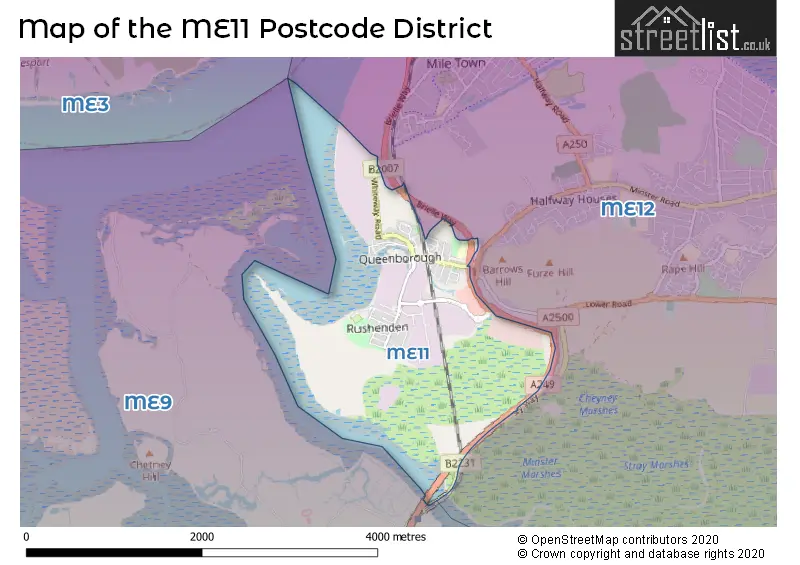
The postcode area has a boundary with Thames Estuary.
The ME11 Postcode shares a border with ME12 (Minster On Sea, SHEERNESS, Leysdown-on-Sea) and ME9 (Iwade, Teynham, Newington).
The primary settlement in the ME11 postcode district is Queenborough, located in the county of Kent. There is another significant settlement called Rushenden in the same postcode district. The post town for this postcode district is Queenborough.
For the district ME11, we have data on 1 postcode sectors. Here's a breakdown: The sector ME11 5, covers Queenborough in Kent.
ME11 Postcode Sectors

Map of the ME11 Postcode District
Explore the ME11 postcode district by using our free interactive map.
When it comes to local government, postal geography often disregards political borders. However, for a breakdown in the ME11 District: the district mostly encompasses the Swale District (B) area with a total of 105 postcodes.
Recent House Sales in ME11
| Date | Price | Address |
|---|---|---|
| 29/09/2023 | £260,000 | Hardy Close, Queenborough, ME11 5AU |
| 06/09/2023 | £430,000 | High Street, Queenborough, ME11 5AG |
| 04/09/2023 | £155,000 | Well Road, Rushenden, Queenborough, ME11 5LB |
| 24/07/2023 | £275,000 | Hardy Close, Queenborough, ME11 5AU |
| 21/07/2023 | £80,000 | Alsager Avenue, Queenborough, ME11 5JN |
| 21/07/2023 | £185,100 | First Avenue, Queenborough, ME11 5JF |
| 17/07/2023 | £490,000 | High Street, Queenborough, ME11 5AQ |
| 13/07/2023 | £222,500 | Harold Street, Queenborough, ME11 5BE |
| 13/07/2023 | £280,000 | High Street, Queenborough, ME11 5AG |
| 22/06/2023 | £255,000 | Barler Place, Queenborough, ME11 5BX |
Weather Forecast for ME11
Press Button to Show Forecast for Sheerness
| Time Period | Icon | Description | Temperature | Rain Probability | Wind |
|---|---|---|---|---|---|
| 09:00 to 12:00 | Cloudy | 8.0°C (feels like 5.0°C) | 5.00% | NE 9 mph | |
| 12:00 to 15:00 | Cloudy | 9.0°C (feels like 7.0°C) | 8.00% | E 9 mph | |
| 15:00 to 18:00 | Cloudy | 10.0°C (feels like 7.0°C) | 10.00% | E 9 mph | |
| 18:00 to 21:00 | Cloudy | 9.0°C (feels like 7.0°C) | 10.00% | E 9 mph | |
| 21:00 to 00:00 | Cloudy | 8.0°C (feels like 6.0°C) | 11.00% | E 9 mph |
Press Button to Show Forecast for Sheerness
| Time Period | Icon | Description | Temperature | Rain Probability | Wind |
|---|---|---|---|---|---|
| 00:00 to 03:00 | Cloudy | 8.0°C (feels like 6.0°C) | 16.00% | ENE 9 mph | |
| 03:00 to 06:00 | Cloudy | 8.0°C (feels like 5.0°C) | 17.00% | ENE 9 mph | |
| 06:00 to 09:00 | Cloudy | 8.0°C (feels like 5.0°C) | 17.00% | ENE 11 mph | |
| 09:00 to 12:00 | Overcast | 10.0°C (feels like 7.0°C) | 18.00% | E 11 mph | |
| 12:00 to 15:00 | Cloudy | 11.0°C (feels like 9.0°C) | 16.00% | E 13 mph | |
| 15:00 to 18:00 | Cloudy | 11.0°C (feels like 8.0°C) | 17.00% | ENE 13 mph | |
| 18:00 to 21:00 | Light rain | 11.0°C (feels like 8.0°C) | 52.00% | ENE 13 mph | |
| 21:00 to 00:00 | Light rain | 11.0°C (feels like 8.0°C) | 50.00% | ENE 16 mph |
Press Button to Show Forecast for Sheerness
| Time Period | Icon | Description | Temperature | Rain Probability | Wind |
|---|---|---|---|---|---|
| 00:00 to 03:00 | Light rain | 11.0°C (feels like 9.0°C) | 54.00% | E 11 mph | |
| 03:00 to 06:00 | Light rain | 11.0°C (feels like 9.0°C) | 51.00% | SE 11 mph | |
| 06:00 to 09:00 | Light rain | 10.0°C (feels like 8.0°C) | 48.00% | SE 11 mph | |
| 09:00 to 12:00 | Light rain shower (day) | 12.0°C (feels like 9.0°C) | 40.00% | SSE 16 mph | |
| 12:00 to 15:00 | Light rain shower (day) | 13.0°C (feels like 10.0°C) | 45.00% | S 16 mph | |
| 15:00 to 18:00 | Light rain shower (day) | 14.0°C (feels like 10.0°C) | 37.00% | SSW 16 mph | |
| 18:00 to 21:00 | Light rain shower (day) | 13.0°C (feels like 11.0°C) | 34.00% | SW 11 mph | |
| 21:00 to 00:00 | Partly cloudy (night) | 11.0°C (feels like 8.0°C) | 8.00% | SW 11 mph |
Where is the ME11 Postcode District?
The data provided indicates that the postcode district ME11 is located in Queenborough. Queenborough is surrounded by several nearby towns, including Sheerness to the north (1.87 miles away), Sittingbourne to the south (3.35 miles away), Rochester to the east (4.62 miles away), Gillingham to the west (8.25 miles away), Faversham to the southeast (9.79 miles away), and Canvey Island to the northwest (10.84 miles away). Furthermore, Queenborough is located at a distance of 38.43 miles from the center of London.
The district is within the post town of QUEENBOROUGH.
The sector has postcodes within the nation of England.
The ME11 Postcode District is in the Kent Thames Gateway region of Kent within the South East (England).
Postcode Sectors within the ME11 District
| Postcode Sector | Delivery Office |
|---|---|
| ME11 5 | Sheerness Delivery Office |
| M | E | 1 | 1 | - | X | X | X |
| M | E | 1 | 1 | Space | Numeric | Letter | Letter |
Current Monthly Rental Prices
| # Bedrooms | Min Price | Max Price | Avg Price |
|---|---|---|---|
| £570 | £570 | £570 | |
| 4 | £1,300 | £1,300 | £1,300 |
Current House Prices
| # Bedrooms | Min Price | Max Price | Avg Price |
|---|---|---|---|
| £2,000 | £300,000 | £151,000 | |
| 2 | £175,000 | £280,000 | £229,167 |
| 3 | £182,000 | £325,000 | £264,735 |
| 4 | £300,000 | £370,000 | £331,667 |
Estate Agents who Operate in the ME11 District
| Logo | Name | Brand Name | Address | Contact Number | Total Properties |
|---|---|---|---|---|---|
 | Sheerness | Wards | 10 Broadway, Sheerness, Kent, ME12 1AF | 01795 905207 | 6 |
 | Worthing | Homewise | 1 Liverpool Gardens Worthing BN11 1TF | 01903 497338 | 5 |
 | Sheerness | haart | 85 High Street, Sheerness, ME12 1TX | 01795 718654 | 3 |
 | Sittingbourne | Family Homes Sales & Lettings | 25a, West Street, Sittingbourne, ME10 1AL | 01795 718669 | 2 |
 | Sheerness | Mann | 35 Broadway, Sheerness, Kent, ME12 1TP | 01795 718638 | 2 |
| Type of Property | 2018 Average | 2018 Sales | 2017 Average | 2017 Sales | 2016 Average | 2016 Sales | 2015 Average | 2015 Sales |
|---|---|---|---|---|---|---|---|---|
| Detached | £251,997 | 7 | £190,000 | 1 | £175,000 | 1 | £177,667 | 3 |
| Semi-Detached | £228,320 | 42 | £192,800 | 10 | £178,433 | 15 | £156,940 | 18 |
| Terraced | £187,101 | 42 | £174,434 | 39 | £157,645 | 31 | £132,755 | 42 |
| Flats | £84,360 | 11 | £103,417 | 6 | £102,125 | 4 | £85,000 | 5 |