The NG23 6 postcode sector is within the county of Nottinghamshire.
Did you know? According to the 2021 Census, the NG23 6 postcode sector is home to a bustling 5,663 residents!
Given that each sector allows for 400 unique postcode combinations. Letters C, I, K, M, O and V are not allowed in the last two letters of a postcode. With 263 postcodes already in use, this leaves 137 units available.
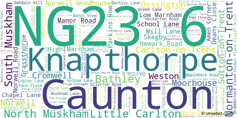
The largest settlement in the NG23 6 postal code is Sutton-on-Trent followed by North Muskham, and Caunton.
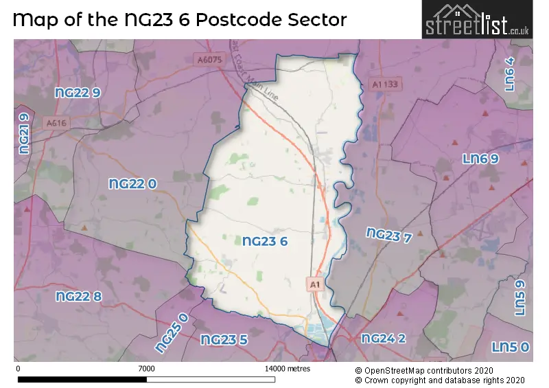
The NG23 6 Postcode shares a border with NG22 0 (Tuxford, East Markham, Wellow), NG22 8 (Bilsthorpe, Farnsfield, Kirklington), NG23 5 (Long Bennington, Claypole, Elston), NG23 7 (Collingham, Harby, Thorney), NG24 1 (NEWARK), NG24 2 (NEWARK, Coddington, Winthorpe) and NG25 0 (SOUTHWELL, Fiskerton, Oxton).
The sector is within the post town of NEWARK.
NG23 6 is a postcode sector within the NG23 postcode district which is within the NG Nottingham postcode area.
The Royal Mail delivery office for the NG23 6 postal sector is the Newark Delivery Office.
The area of the NG23 6 postcode sector is 39.98 square miles which is 103.55 square kilometres or 25,587.13 square acres.
The NG23 6 postcode sector is crossed by the A1 Major A road.
Waterways within the NG23 6 postcode sector include the River Trent, The Beck, Slough Dyke, The Fleet.

Map of the NG23 6 Postcode Sector
Explore the NG23 6 postcode sector by using our free interactive map.
| N | G | 2 | 3 | - | 6 | X | X |
| N | G | 2 | 3 | Space | 6 | Letter | Letter |
Official List of Streets
Caunton (13 Streets)
Sutton-on-Trent (37 Streets)
Little Carlton (4 Streets)
North Muskham (30 Streets)
Norwell (13 Streets)
South Muskham (7 Streets)
Normanton-on-Trent (12 Streets)
Weston (13 Streets)
Carlton-on-Trent (9 Streets)
Bathley (9 Streets)
Cromwell (6 Streets)
High Marnham (3 Streets)
Ossington (5 Streets)
Low Marnham (2 Streets)
Grassthorpe (2 Streets)
Unofficial Streets or Alternative Spellings
Hockerton
CAUNTON ROADTuxford
MARNHAM ROADEgmanton
HAGG LANE MOORHOUSE ROAD WESTON ROADNew Ollerton
NEWARK ROADWeather Forecast for NG23 6
Press Button to Show Forecast for Norwell
| Time Period | Icon | Description | Temperature | Rain Probability | Wind |
|---|---|---|---|---|---|
| 03:00 to 06:00 | Cloudy | 12.0°C (feels like 11.0°C) | 14.00% | ENE 2 mph | |
| 06:00 to 09:00 | Mist | 12.0°C (feels like 12.0°C) | 19.00% | WNW 2 mph | |
| 09:00 to 12:00 | Cloudy | 15.0°C (feels like 15.0°C) | 11.00% | NNW 4 mph | |
| 12:00 to 15:00 | Cloudy | 18.0°C (feels like 17.0°C) | 15.00% | NNW 4 mph | |
| 15:00 to 18:00 | Light rain shower (day) | 18.0°C (feels like 18.0°C) | 33.00% | N 4 mph | |
| 18:00 to 21:00 | Light rain shower (day) | 17.0°C (feels like 17.0°C) | 32.00% | NNW 4 mph | |
| 21:00 to 00:00 | Partly cloudy (night) | 14.0°C (feels like 13.0°C) | 4.00% | N 7 mph |
Press Button to Show Forecast for Norwell
| Time Period | Icon | Description | Temperature | Rain Probability | Wind |
|---|---|---|---|---|---|
| 00:00 to 03:00 | Clear night | 12.0°C (feels like 12.0°C) | 6.00% | N 7 mph | |
| 03:00 to 06:00 | Partly cloudy (night) | 12.0°C (feels like 11.0°C) | 10.00% | NNW 7 mph | |
| 06:00 to 09:00 | Overcast | 12.0°C (feels like 12.0°C) | 16.00% | NW 4 mph | |
| 09:00 to 12:00 | Overcast | 15.0°C (feels like 14.0°C) | 18.00% | NW 7 mph | |
| 12:00 to 15:00 | Cloudy | 18.0°C (feels like 17.0°C) | 19.00% | NNW 7 mph | |
| 15:00 to 18:00 | Light rain shower (day) | 19.0°C (feels like 18.0°C) | 40.00% | N 7 mph | |
| 18:00 to 21:00 | Partly cloudy (day) | 18.0°C (feels like 17.0°C) | 14.00% | ENE 7 mph | |
| 21:00 to 00:00 | Clear night | 14.0°C (feels like 13.0°C) | 3.00% | NNE 7 mph |
Press Button to Show Forecast for Norwell
| Time Period | Icon | Description | Temperature | Rain Probability | Wind |
|---|---|---|---|---|---|
| 00:00 to 03:00 | Partly cloudy (night) | 12.0°C (feels like 11.0°C) | 5.00% | NNE 7 mph | |
| 03:00 to 06:00 | Cloudy | 11.0°C (feels like 10.0°C) | 10.00% | N 7 mph | |
| 06:00 to 09:00 | Cloudy | 12.0°C (feels like 11.0°C) | 10.00% | N 7 mph | |
| 09:00 to 12:00 | Cloudy | 15.0°C (feels like 14.0°C) | 11.00% | N 9 mph | |
| 12:00 to 15:00 | Partly cloudy (day) | 18.0°C (feels like 16.0°C) | 13.00% | NNE 9 mph | |
| 15:00 to 18:00 | Partly cloudy (day) | 18.0°C (feels like 16.0°C) | 33.00% | NNE 9 mph | |
| 18:00 to 21:00 | Light rain shower (day) | 17.0°C (feels like 15.0°C) | 32.00% | NE 9 mph | |
| 21:00 to 00:00 | Clear night | 13.0°C (feels like 12.0°C) | 2.00% | NNE 7 mph |
Schools and Places of Education Within the NG23 6 Postcode Sector
Caunton Dean Hole CofE Primary School
Voluntary controlled school
Manor Road, Newark, Nottinghamshire, NG23 6AD
Head: Mr Alan Brown
Ofsted Rating: Good
Inspection: 2019-02-05 (1927 days ago)
Website: Visit Caunton Dean Hole CofE Primary School Website
Phone: 01636636219
Number of Pupils: 26
Muskham Primary School
Community school
Main Street, Newark, Nottinghamshire, NG23 6HD
Head: Mrs Amanda Crossland
Ofsted Rating: Good
Inspection: 2019-05-09 (1834 days ago)
Website: Visit Muskham Primary School Website
Phone: 01636702254
Number of Pupils: 172
Norwell CofE Primary School
Voluntary controlled school
School Lane, Newark, Nottinghamshire, NG23 6JP
Head: Mrs Kathryn King
Ofsted Rating: Good
Inspection: 2019-02-13 (1919 days ago)
Website: Visit Norwell CofE Primary School Website
Phone: 01636636244
Number of Pupils: 55
St Matthew's CofE Primary School
Voluntary controlled school
Mill Lane, Newark, Nottinghamshire, NG23 6RW
Head: Mrs Kathryn King
Ofsted Rating: Good
Inspection: 2019-02-06 (1926 days ago)
Website: Visit St Matthew's CofE Primary School Website
Phone: 01636821217
Number of Pupils: 44
Sutton-On-Trent Primary and Nursery School
Community school
Church Street, Newark, Nottinghamshire, NG23 6PD
Head: Mrs Jenny Hutchinson
Ofsted Rating: Good
Inspection: 2023-05-04 (378 days ago)
Website: Visit Sutton-On-Trent Primary and Nursery School Website
Phone: 01636821286
Number of Pupils: 126
House Prices in the NG23 6 Postcode Sector
| Type of Property | 2018 Average | 2018 Sales | 2017 Average | 2017 Sales | 2016 Average | 2016 Sales | 2015 Average | 2015 Sales |
|---|---|---|---|---|---|---|---|---|
| Detached | £350,852 | 61 | £289,074 | 68 | £286,074 | 62 | £277,840 | 72 |
| Semi-Detached | £208,385 | 13 | £193,700 | 15 | £182,133 | 29 | £185,274 | 29 |
| Terraced | £233,750 | 4 | £170,825 | 6 | £122,000 | 2 | £154,438 | 8 |
| Flats | £0 | 0 | £0 | 0 | £0 | 0 | £0 | 0 |
Important Postcodes NG23 6 in the Postcode Sector
NG23 6HD is the postcode for Muskham Primary School, Main Street, and Muskham Primary School, Main Street, North Muskham
NG23 6JP is the postcode for Norwell C of E Primary School, School Lane
NG23 6PD is the postcode for Sutton On Trent Primary School, Church Street, Sutton Primary School, Church Street, and OLD BLOCK, Sutton Primary School, Church Street
NG23 6RW is the postcode for St. Matthews C of E School, Mill Lane
| The NG23 6 Sector is within these Local Authorities |
|
|---|---|
| The NG23 6 Sector is within these Counties |
|
| The NG23 6 Sector is within these Water Company Areas |
|