The NG34 9 postcode sector is within the county of Lincolnshire.
Did you know? According to the 2021 Census, the NG34 9 postcode sector is home to a bustling 11,309 residents!
Given that each sector allows for 400 unique postcode combinations. Letters C, I, K, M, O and V are not allowed in the last two letters of a postcode. With 315 postcodes already in use, this leaves 85 units available.
The largest settlement in the NG34 9 postal code is Ruskington followed by Heckington, and Great Hale.
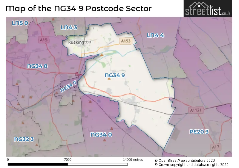
The NG34 9 Postcode shares a border with NG34 7 (SLEAFORD), NG34 8 (SLEAFORD, Leasingham, Cranwell), PE20 3 (Swineshead, Bicker, Amber Hill), LN4 3 (Metheringham, Ashby De La Launde, Digby), LN4 4 (Tattershall, Coningsby, Billinghay) and NG34 0 (Billingborough, Folkingham, Helpringham).
The sector is within the post town of SLEAFORD.
NG34 9 is a postcode sector within the NG34 postcode district which is within the NG Nottingham postcode area.
The Royal Mail delivery office for the NG34 9 postal sector is the Sleaford Delivery Office.
The area of the NG34 9 postcode sector is 36.40 square miles which is 94.27 square kilometres or 23,293.82 square acres.
Waterways within the NG34 9 postcode sector include the Great Hale Eau, Old Forty Foot.

Map of the NG34 9 Postcode Sector
Explore the NG34 9 postcode sector by using our free interactive map.
| N | G | 3 | 4 | - | 9 | X | X |
| N | G | 3 | 4 | Space | 9 | Letter | Letter |
Official List of Streets
Ruskington (93 Streets)
Heckington (74 Streets)
Anwick (12 Streets)
Ewerby (5 Streets)
Great Hale (26 Streets)
SLEAFORD (2 Streets)
Little Hale (4 Streets)
Kirkby-la-Thorpe (4 Streets)
Howell (2 Streets)
Anwick Fen (1 Streets)
Evedon (1 Streets)
Unofficial Streets or Alternative Spellings
Ruskington
FINCH-HATTON CLOSE THE ORCHARDS PARK ANWICK ROAD BECKSTONE BRIDGE BLACK DROVE BLACKSMITHS COTTAGE LAYBY CLAY PIT LANE COBHAM HOUSE CRAB LANE EVEDON CHURCH LANE FEN DROVE FERRY BRIDGE FIVE WILLOW WATH BRIDGE FOX HALL LANE GRANGE FARM LANE GREAT HALE FEN GREEN LANE HALFMILE LANE HALFPENNY TOLL LANE HIGH STREET NORTH HIGH STREET SOUTH KIRKBY ROAD LAMBOURNE CLOSE LITTLE HALE DROVE LITTLEWORTH DROVE OLD FORTY FOOT BANK PARK-LEA PRIORY PARK PUMP LANE RED BRIDGE ROXHOLM ROAD RUSKINGTON FEN ROAD RUSKINGTON TRAIN STATION SAINT CLEMENTS ROAD SANDLEES LANE SLEAFORD BYPASS SPEEDWAY CORNER STAR FEN DROVE STAR FEN END THE HARDINGS WOOD ROADSLEAFORD
EAST ROADNorth Kyme
SLEAFORD ROADLeasingham Moor
HOLDINGHAM LANEDorrington
SLEAFORD ROADSchools and Places of Education Within the NG34 9 Postcode Sector
Heckington St Andrew's Church of England School
Voluntary controlled school
Heckington St. Andrew's C of E Primary School, Sleaford, Lincolnshire, NG34 9RX
Head: Mrs Judith Bentley
Ofsted Rating: Requires improvement
Inspection: 2022-03-02 (813 days ago)
Website: Visit Heckington St Andrew's Church of England School Website
Phone: 01529460633
Number of Pupils: 168
Ruskington Chestnut Street Church of England Academy
Academy converter
Chestnut Street, Sleaford, Lincolnshire, NG34 9DL
Head: Mr George Trafford
Ofsted Rating: Good
Inspection: 2023-01-18 (491 days ago)
Website: Visit Ruskington Chestnut Street Church of England Academy Website
Phone: 01526832424
Number of Pupils: 197
The Kirkby-la-Thorpe Church of England Primary School
Academy converter
Church Lane, Sleaford, Lincolnshire, NG34 9NU
Head: Mrs Clare Early
Ofsted Rating: Good
Inspection: 2023-03-14 (436 days ago)
Website: Visit The Kirkby-la-Thorpe Church of England Primary School Website
Phone: 01529302595
Number of Pupils: 118
Winchelsea Primary School Ruskington
Community school
4a Sleaford Road, Sleaford, Lincolnshire, NG34 9BY
Head: Miss Helen Duckett
Ofsted Rating: Good
Inspection: 2023-04-20 (399 days ago)
Website: Visit Winchelsea Primary School Ruskington Website
Phone: 01526832060
Number of Pupils: 231
House Prices in the NG34 9 Postcode Sector
| Type of Property | 2018 Average | 2018 Sales | 2017 Average | 2017 Sales | 2016 Average | 2016 Sales | 2015 Average | 2015 Sales |
|---|---|---|---|---|---|---|---|---|
| Detached | £240,392 | 119 | £249,700 | 127 | £220,340 | 166 | £212,036 | 134 |
| Semi-Detached | £156,626 | 93 | £144,998 | 87 | £138,502 | 63 | £133,868 | 69 |
| Terraced | £155,660 | 35 | £126,981 | 18 | £139,808 | 13 | £125,235 | 17 |
| Flats | £0 | 0 | £0 | 0 | £0 | 0 | £142,000 | 1 |
Important Postcodes NG34 9 in the Postcode Sector
NG34 9BY is the postcode for Cotelands School, Sleaford Road, Winchelsea Cp School, 4a Sleaford Road, and Winchelsea Primary School, Sleaford Road, Ruskington
NG34 9DL is the postcode for Ruskington Chestnut Street C of E Primary School, 19a Chestnut Street, and Ruskington Chestnut Street C of E Primary School, 19a Chestnut Street, Ruskington
NG34 9NU is the postcode for Kirkby la Thorpe Primary School, Church Lane
NG34 9RX is the postcode for Heckington St. Andrews C of E School, Howell Road, Heckington, and Heckington St. Andrews C of E School, Howell Road
| The NG34 9 Sector is within these Local Authorities |
|
|---|---|
| The NG34 9 Sector is within these Counties |
|
| The NG34 9 Sector is within these Water Company Areas |
|
Tourist Attractions within the NG34 9 Postcode Area
We found 2 visitor attractions within the NG34 postcode area
| North Ings Farm Museum |
|---|
| Museums & Art Galleries |
| Museum and / or Art Gallery |
| View North Ings Farm Museum on Google Maps |
| Heckington Village Trust Railway & Heritage Museum |
| Museums & Art Galleries |
| Museum and / or Art Gallery |
| View Heckington Village Trust Railway & Heritage Museum on Google Maps |