The PR26 7 postcode sector is within the county of Lancashire.
Did you know? According to the 2021 Census, the PR26 7 postcode sector is home to a bustling 6,055 residents!
Given that each sector allows for 400 unique postcode combinations. Letters C, I, K, M, O and V are not allowed in the last two letters of a postcode. With 106 postcodes already in use, this leaves 294 units available.
The largest settlement in the PR26 7 postal code is LEYLAND followed by Moss Side, and Midge Hall.
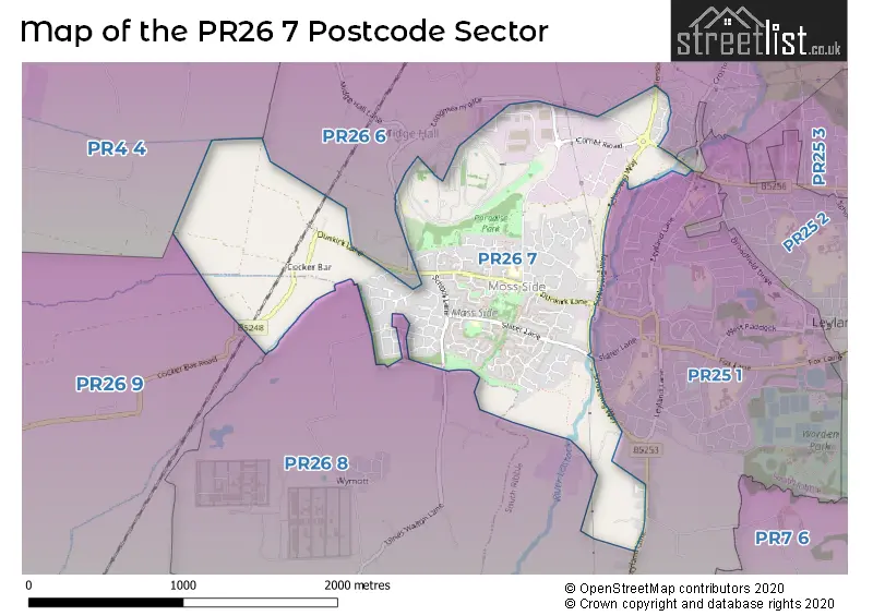
The PR26 7 Postcode shares a border with PR26 6 (Farington Moss, LEYLAND, Midge Hall), PR26 8 (LEYLAND), PR4 4 (New Longton, Much Hoole, Whitestake), PR25 1 (LEYLAND) and PR26 9 (Croston, Bretherton).
The sector is within the post town of LEYLAND.
PR26 7 is a postcode sector within the PR2 postcode district which is within the PR Preston postcode area.
The Royal Mail delivery office for the PR26 7 postal sector is the Preston Central Delivery Office.
The area of the PR26 7 postcode sector is 1.50 square miles which is 3.89 square kilometres or 962.19 square acres.
Waterways within the PR26 7 postcode sector include the Carr Brook, Wymott Brook, River Lostock.

Map of the PR26 7 Postcode Sector
Explore the PR26 7 postcode sector by using our free interactive map.
| P | R | 2 | 6 | - | 7 | X | X |
| P | R | 2 | 6 | Space | 7 | Letter | Letter |
Official List of Streets
LEYLAND (81 Streets)
Moss Side (3 Streets)
Midge Hall (1 Streets)
Unofficial Streets or Alternative Spellings
LEYLAND
EMNIE LANE HUGH LANE LEYLAND LANE LOWTHER DRIVE NIXON LANE ST. JAMES GARDENS ULNES WALTON LANEFarington Moss
CROSTON ROAD RADCLIFFE DRIVE BISON PLACE BRAKING STRAIGHT CLYDESDALE PLACE FLENSBURG WAY LANSBOROUGH CLOSE LONG MOSS LANE MARATHON PLACE MOSS SIDE SHOPS NO. 1 CIRCUIT NO. 2 CIRCUIT PAV� & CORRUGATIONS CIRCUIT PEREGRINE PLACE PUMP HOUSE LANE REIVER ROAD SCHLESWIG WAY SMITH CROFT ST JAMESS GARDENS TEST HILL THE MEADOWS THE ORCHARD WADING TROUGHBretherton
COCKER BAR ROADSchools and Places of Education Within the PR26 7 Postcode Sector
Aurora Brooklands School
Other independent special school
159 Longmeanygate, Leyland, Lancashire, PR26 7TB
Head: Mrs Sarah Gregory
Ofsted Rating: Requires improvement
Inspection: 2023-09-28 (251 days ago)
Website: Visit Aurora Brooklands School Website
Phone: 01772454826
Number of Pupils: 57
Leyland St James Church of England Primary School
Voluntary aided school
Slater Lane, Leyland, Lancashire, PR26 7SH
Head: Karen Chadwick
Ofsted Rating: Good
Inspection: 2023-06-07 (364 days ago)
Website: Visit Leyland St James Church of England Primary School Website
Phone: 01772422572
Number of Pupils: 207
Moss Side Primary School
Community school
Paradise Lane, Leyland, Lancashire, PR26 7ST
Head: Mr Andrew Wright
Ofsted Rating: Outstanding
Inspection: 2013-07-10 (3983 days ago)
Website: Visit Moss Side Primary School Website
Phone: 01772432048
Number of Pupils: 259
House Prices in the PR26 7 Postcode Sector
| Type of Property | 2018 Average | 2018 Sales | 2017 Average | 2017 Sales | 2016 Average | 2016 Sales | 2015 Average | 2015 Sales |
|---|---|---|---|---|---|---|---|---|
| Detached | £225,330 | 48 | £232,297 | 48 | £217,456 | 45 | £196,976 | 50 |
| Semi-Detached | £147,496 | 24 | £143,861 | 18 | £132,562 | 26 | £129,200 | 10 |
| Terraced | £104,750 | 16 | £106,272 | 26 | £122,250 | 8 | £93,769 | 24 |
| Flats | £67,000 | 1 | £65,000 | 1 | £54,000 | 3 | £77,000 | 3 |
Important Postcodes PR26 7 in the Postcode Sector
PR26 7SH is the postcode for St. James C of E School, Slater Lane
PR26 7ST is the postcode for Moss Side Cp School, Paradise Lane
| The PR26 7 Sector is within these Local Authorities |
|
|---|---|
| The PR26 7 Sector is within these Counties |
|
| The PR26 7 Sector is within these Water Company Areas |
|