The PR26 9 postcode sector is within the county of Lancashire.
Did you know? According to the 2021 Census, the PR26 9 postcode sector is home to a bustling 3,813 residents!
Given that each sector allows for 400 unique postcode combinations. Letters C, I, K, M, O and V are not allowed in the last two letters of a postcode. With 89 postcodes already in use, this leaves 311 units available.
The largest settlements in the PR26 9 postal code are Croston and Bretherton.
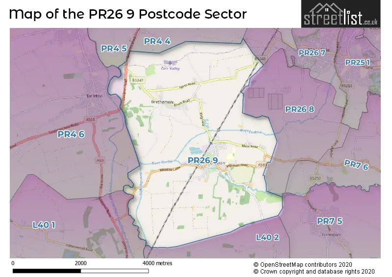
The PR26 9 Postcode shares a border with PR26 7 (LEYLAND, Moss Side, Midge Hall), PR26 8 (LEYLAND), L40 1 (Rufford, Holmeswood), PR4 4 (New Longton, Much Hoole, Whitestake), PR4 5 (Longton, Hutton, Walmer Bridge), PR4 6 (Tarleton, Hesketh Bank, Mere Brow), PR7 5 (Coppull, Eccleston, Charnock Richard) and L40 2 (Mawdesley).
The sector is within the post town of LEYLAND.
PR26 9 is a postcode sector within the PR2 postcode district which is within the PR Preston postcode area.
The Royal Mail delivery office for the PR26 9 postal sector is the Preston Central Delivery Office.
The area of the PR26 9 postcode sector is 8.72 square miles which is 22.58 square kilometres or 5,579.03 square acres.
Waterways within the PR26 9 postcode sector include the River Yarrow, Carr Brook, Wymott Brook, River Lostock, River Douglas.

Map of the PR26 9 Postcode Sector
Explore the PR26 9 postcode sector by using our free interactive map.
| P | R | 2 | 6 | - | 9 | X | X |
| P | R | 2 | 6 | Space | 9 | Letter | Letter |
Official List of Streets
Croston (51 Streets)
Bretherton (17 Streets)
Unofficial Streets or Alternative Spellings
Much Hoole
CARR LANE LIVERPOOL OLD ROADSchools and Places of Education Within the PR26 9 Postcode Sector
Bishop Rawstorne Church of England Academy
Academy converter
Highfield Road, Leyland, Lancashire, PR26 9HH
Head: Mr Paul Cowley
Ofsted Rating: Good
Inspection: 2021-11-17 (918 days ago)
Website: Visit Bishop Rawstorne Church of England Academy Website
Phone: 01772600349
Number of Pupils: 962
Bretherton Endowed Church of England Voluntary Aided Primary School
Voluntary aided school
South Road, Leyland, Lancashire, PR26 9AH
Head: Mrs Alison Moxham
Ofsted Rating: Good
Inspection: 2023-11-29 (176 days ago)
Website: Visit Bretherton Endowed Church of England Voluntary Aided Primary School Website
Phone: 01772600431
Number of Pupils: 107
Trinity and St Michael's VA CofE/Methodist Primary School
Voluntary aided school
Out Lane, Leyland, Lancashire, PR26 9HJ
Head: Mrs Claire Procter
Ofsted Rating: Outstanding
Inspection: 2016-03-09 (2997 days ago)
Website: Visit Trinity and St Michael's VA CofE/Methodist Primary School Website
Phone: 01772600379
Number of Pupils: 216
House Prices in the PR26 9 Postcode Sector
| Type of Property | 2018 Average | 2018 Sales | 2017 Average | 2017 Sales | 2016 Average | 2016 Sales | 2015 Average | 2015 Sales |
|---|---|---|---|---|---|---|---|---|
| Detached | £356,181 | 19 | £392,834 | 25 | £321,231 | 13 | £395,687 | 36 |
| Semi-Detached | £200,633 | 24 | £206,237 | 19 | £235,770 | 15 | £222,111 | 22 |
| Terraced | £186,133 | 35 | £177,597 | 37 | £163,458 | 24 | £179,492 | 24 |
| Flats | £128,250 | 4 | £98,000 | 1 | £62,500 | 3 | £277,500 | 2 |
Important Postcodes PR26 9 in the Postcode Sector
PR26 9AH is the postcode for Bretherton Endowed C of E School, South Road
PR26 9HH is the postcode for SPORTS HALL, Bishop Rawstorne C of E Academy, Highfield Road, MAIN BUILDING, Bishop Rawstorne C of E Academy, Highfield Road, TECHNOLOGY BLOCK, Bishop Rawstorne C of E Academy, Highfield Road, SCIENCE BLOCK, Bishop Rawstorne C of E Academy, Highfield Road, ADMINISTRATION BLOCK, Bishop Rawstorne C of E Academy, Highfield Road, and ENGLISH BLOCK, Bishop Rawstorne C of E Academy, Highfield Road
PR26 9HJ is the postcode for Bishop Rawstone Language College, Out Lane, Trinity & St. Michaels, Out Lane, Trinity And St Michael's Church Of England And Methodist Primary School, Out Lane, MAIN BUILDING, Bishop Rawstone Language College, Out Lane, and TECHNOLOGY CENTRE, Bishop Rawstone Language College, Out Lane
| The PR26 9 Sector is within these Local Authorities |
|
|---|---|
| The PR26 9 Sector is within these Counties |
|
| The PR26 9 Sector is within these Water Company Areas |
|