The TR20 9 postcode sector is within the county of Cornwall.
Did you know? According to the 2021 Census, the TR20 9 postcode sector is home to a bustling 4,459 residents!
Given that each sector allows for 400 unique postcode combinations. Letters C, I, K, M, O and V are not allowed in the last two letters of a postcode. With 220 postcodes already in use, this leaves 180 units available.
The largest settlement in the TR20 9 postal code is Goldsithney followed by Praa Sands, and Rosudgeon.
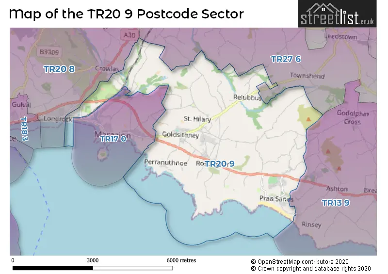
The TR20 9 Postcode shares a border with TR17 0 (MARAZION), TR13 9 (Porthleven, Breage, Ashton), TR20 8 (Long Rock, Ludgvan, Crowlas) and TR27 6 (St. Erth, Leedstown, HAYLE).
The sector is within the post town of PENZANCE.
TR20 9 is a postcode sector within the TR20 postcode district which is within the TR Truro postcode area.
The Royal Mail delivery office for the TR20 9 postal sector is the Penzance Delivery Office.
The area of the TR20 9 postcode sector is 11.75 square miles which is 30.43 square kilometres or 7,519.35 square acres.

Map of the TR20 9 Postcode Sector
Explore the TR20 9 postcode sector by using our free interactive map.
| T | R | 2 | 0 | - | 9 | X | X |
| T | R | 2 | 0 | Space | 9 | Letter | Letter |
Official List of Streets
Goldsithney (34 Streets)
Perranuthnoe (6 Streets)
Rosudgeon (22 Streets)
Praa Sands (18 Streets)
Germoe (9 Streets)
St. Hilary (7 Streets)
Long Rock (1 Streets)
Relubbus (2 Streets)
Unofficial Streets or Alternative Spellings
Ashton
HENDRA LANE TREVURVAS LANE BAMPFLYDE WAY BELVEDERE LANE BOSWORGY ROAD CHIVERTON GATE CHY-AN-DOUR ROAD CHYNOWETH LANE EDNOVEAN LANE GURLYN HILL LONG LANE LONGROCK ROAD NEWTOWN LANE PERRAN DOWNS WAY PERRANS DOWN LANE PRIMROSE LANE RETALLACK GARDENS ROSEVIDNEY LANE ROWS ROAD SAINT AUBYNS SAINT PETRY SAINT PIRANS WAY THE AVENUE THE DUNES THE LINKS THE MEWS TREWITHEN TERRACE TRUTHWALL LANE WELL LANETownshend
BOSENCE ROADSt. Erth Praze
TREVEN LANECrowlas
ROSPEATH LANESchools and Places of Education Within the TR20 9 Postcode Sector
Germoe Community Primary School
Foundation school
Germoe Lane, Penzance, Cornwall, TR20 9QY
Head: Miss Paula Blackburn
Ofsted Rating: Good
Inspection: 2018-03-21 (2255 days ago)
Website: Visit Germoe Community Primary School Website
Phone: 01736763310
Number of Pupils: 66
St Hilary School
Academy converter
School Lane, Penzance, Cornwall, TR20 9DR
Head: Mr Robin Hamshar
Ofsted Rating: Good
Inspection: 2023-09-27 (239 days ago)
Website: Visit St Hilary School Website
Phone: 01736763324
Number of Pupils: 241
House Prices in the TR20 9 Postcode Sector
| Type of Property | 2018 Average | 2018 Sales | 2017 Average | 2017 Sales | 2016 Average | 2016 Sales | 2015 Average | 2015 Sales |
|---|---|---|---|---|---|---|---|---|
| Detached | £461,615 | 49 | £373,893 | 61 | £360,625 | 51 | £332,064 | 46 |
| Semi-Detached | £249,468 | 14 | £235,818 | 11 | £260,193 | 15 | £183,697 | 15 |
| Terraced | £190,615 | 13 | £200,429 | 14 | £190,950 | 20 | £175,750 | 14 |
| Flats | £350,000 | 1 | £372,150 | 8 | £198,357 | 7 | £342,500 | 2 |
Important Postcodes TR20 9 in the Postcode Sector
TR20 9DR is the postcode for St. Hilary School, School Lane, St. Hilary, and St. Hilary School, School Lane
| The TR20 9 Sector is within these Local Authorities |
|
|---|---|
| The TR20 9 Sector is within these Counties |
|
| The TR20 9 Sector is within these Water Company Areas |
|