The AB55 postcode district is a postal district located in the AB Aberdeen postcode area with a population of 9,331 residents according to the 2011 Scotland Census.
The area of the AB55 postcode district is 144.29 square miles which is 373.70 square kilometres or 92,344.30 acres.
Currently, the AB55 district has about 424 postcode units spread across 3 geographic postcode sectors.
Given that each sector allows for 400 unique postcode combinations, the district has a capacity of 1,200 postcodes. With 424 postcodes already in use, this leaves 776 units available.
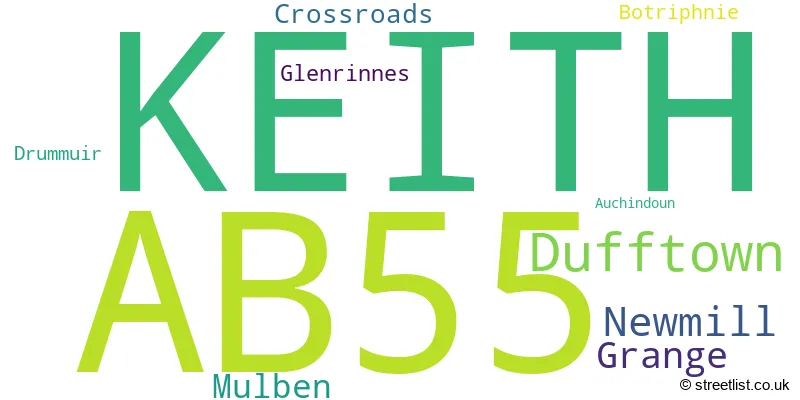
The largest settlement in the AB55 postal code is KEITH followed by Dufftown, and Newmill.
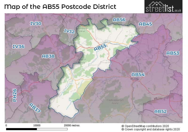
The AB55 Postcode shares a border with AB54 (HUNTLY, Aberchirder, Rhynie), AB45 (BANFF, Portsoy, Whitehills), AB56 (BUCKIE, Cullen, Portknockie), IV32 (FOCHABERS, Mosstodloch, Garmouth), AB37 (Tomintoul, Glenlivet, BALLINDALLOCH) and AB38 (ABERLOUR, Rothes, Craigellachie).
In the AB55 postcode district, the primary settlement is Keith, located in the county of Banffshire. Other significant settlements in this district include Auchindoun, Dufftown, Glenrinnes, Botriphnie, Drummuir, Crossroads, Grange, Mulben, and Newmill, all also located in Banffshire. The most significant post town in this district is Keith.
For the district AB55, we have data on 4 postcode sectors. Here's a breakdown: The sector AB55 4, covers Dufftown and Glenrinnes in Banffshire. The sector AB55 5, covers Keith in Banffshire. The sector AB55 6, covers Newmill and Grange and Mulben and Keith and Crossroads in Banffshire. The sector AB55 9 is non-geographic. It's often designated for PO Boxes, large organisations, or special services.

Map of the AB55 Postcode District
Explore the AB55 postcode district by using our free interactive map.
When it comes to local government, postal geography often disregards political borders. However, for a breakdown in the AB55 District: the district mostly encompasses the Moray (424 postcodes), and finally, the Aberdeenshire area (4 postcodes).
Weather Forecast for AB55
Press Button to Show Forecast for Keith
| Time Period | Icon | Description | Temperature | Rain Probability | Wind |
|---|---|---|---|---|---|
| 06:00 to 09:00 | Cloudy | 3.0°C (feels like 1.0°C) | 4.00% | ESE 2 mph | |
| 09:00 to 12:00 | Cloudy | 7.0°C (feels like 5.0°C) | 16.00% | SE 7 mph | |
| 12:00 to 15:00 | Cloudy | 7.0°C (feels like 5.0°C) | 48.00% | SE 9 mph | |
| 15:00 to 18:00 | Cloudy | 8.0°C (feels like 6.0°C) | 46.00% | SE 9 mph | |
| 18:00 to 21:00 | Cloudy | 7.0°C (feels like 5.0°C) | 12.00% | SE 7 mph | |
| 21:00 to 00:00 | Cloudy | 4.0°C (feels like 1.0°C) | 4.00% | SE 7 mph |
Press Button to Show Forecast for Keith
| Time Period | Icon | Description | Temperature | Rain Probability | Wind |
|---|---|---|---|---|---|
| 00:00 to 03:00 | Clear night | 2.0°C (feels like 0.0°C) | 1.00% | ESE 4 mph | |
| 03:00 to 06:00 | Clear night | 0.0°C (feels like -2.0°C) | 2.00% | E 4 mph | |
| 06:00 to 09:00 | Sunny day | 2.0°C (feels like 1.0°C) | 4.00% | ESE 4 mph | |
| 09:00 to 12:00 | Cloudy | 7.0°C (feels like 5.0°C) | 7.00% | ENE 7 mph | |
| 12:00 to 15:00 | Overcast | 8.0°C (feels like 6.0°C) | 14.00% | NNE 7 mph | |
| 15:00 to 18:00 | Cloudy | 8.0°C (feels like 6.0°C) | 12.00% | N 9 mph | |
| 18:00 to 21:00 | Partly cloudy (day) | 7.0°C (feels like 5.0°C) | 7.00% | N 9 mph | |
| 21:00 to 00:00 | Clear night | 4.0°C (feels like 2.0°C) | 5.00% | W 7 mph |
Press Button to Show Forecast for Keith
| Time Period | Icon | Description | Temperature | Rain Probability | Wind |
|---|---|---|---|---|---|
| 00:00 to 03:00 | Clear night | 3.0°C (feels like 1.0°C) | 1.00% | SW 7 mph | |
| 03:00 to 06:00 | Clear night | 2.0°C (feels like -1.0°C) | 1.00% | SSW 7 mph | |
| 06:00 to 09:00 | Partly cloudy (day) | 4.0°C (feels like 2.0°C) | 1.00% | SSW 7 mph | |
| 09:00 to 12:00 | Partly cloudy (day) | 9.0°C (feels like 7.0°C) | 1.00% | SSW 9 mph | |
| 12:00 to 15:00 | Cloudy | 11.0°C (feels like 9.0°C) | 7.00% | S 13 mph | |
| 15:00 to 18:00 | Cloudy | 12.0°C (feels like 9.0°C) | 7.00% | S 13 mph | |
| 18:00 to 21:00 | Partly cloudy (day) | 10.0°C (feels like 8.0°C) | 3.00% | SSE 13 mph | |
| 21:00 to 00:00 | Cloudy | 8.0°C (feels like 5.0°C) | 4.00% | SSE 11 mph |
Press Button to Show Forecast for Keith
| Time Period | Icon | Description | Temperature | Rain Probability | Wind |
|---|---|---|---|---|---|
| 00:00 to 03:00 | Cloudy | 7.0°C (feels like 4.0°C) | 5.00% | SSE 11 mph | |
| 03:00 to 06:00 | Cloudy | 7.0°C (feels like 4.0°C) | 4.00% | SSE 9 mph | |
| 06:00 to 09:00 | Cloudy | 7.0°C (feels like 5.0°C) | 4.00% | SE 11 mph | |
| 09:00 to 12:00 | Partly cloudy (day) | 11.0°C (feels like 8.0°C) | 2.00% | SSE 13 mph | |
| 12:00 to 15:00 | Partly cloudy (day) | 13.0°C (feels like 10.0°C) | 4.00% | SE 13 mph | |
| 15:00 to 18:00 | Cloudy | 13.0°C (feels like 10.0°C) | 7.00% | SE 13 mph | |
| 18:00 to 21:00 | Partly cloudy (day) | 10.0°C (feels like 8.0°C) | 4.00% | ESE 11 mph | |
| 21:00 to 00:00 | Overcast | 7.0°C (feels like 5.0°C) | 13.00% | ESE 9 mph |
Where is the AB55 Postcode District?
The AB55 postcode district is located in Keith, a town in Scotland. It is surrounded by several nearby towns, including Edinburgh to the west, Fochabers to the north, Huntly to the east, Elgin to the northwest, Ballindalloch to the southwest, and Insch to the southeast. The centre of London is approximately 430.2 miles away from this postcode district.
The district is within the post town of KEITH.
The sector has postcodes within the nation of Scotland.
The AB55 Postcode District is covers the following regions.
- Inverness & Nairn and Moray, Badenoch & Strathspey - Highlands and Islands - Scotland
- Aberdeen City and Aberdeenshire - North Eastern Scotland - Scotland
| Postcode Sector | Delivery Office |
|---|---|
| AB55 4 | Keith Delivery Office |
| AB55 5 | Keith Delivery Office |
| AB55 6 | Keith Delivery Office |
| A | B | 5 | 5 | - | X | X | X |
| A | B | 5 | 5 | Space | Numeric | Letter | Letter |
Current Monthly Rental Prices
| # Bedrooms | Min Price | Max Price | Avg Price |
|---|
Current House Prices
| # Bedrooms | Min Price | Max Price | Avg Price |
|---|---|---|---|
| £120,000 | £300,000 | £186,250 | |
| 2 | £120,000 | £160,000 | £140,000 |
| 3 | £125,000 | £235,000 | £170,550 |
| 4 | £155,000 | £415,000 | £302,500 |
| 5 | £150,000 | £430,000 | £288,333 |
| 6 | £425,000 | £725,000 | £575,000 |
| 8 | £980,000 | £980,000 | £980,000 |
Estate Agents who Operate in the AB55 District
| Logo | Name | Brand Name | Address | Contact Number | Total Properties |
|---|---|---|---|---|---|
 | covering Aberdeen | Purplebricks | Suite 7 First Floor Cranmore Drive Shirley Solihull B90 4RZ | 024 7542 8812 | 6 |
 | Elgin | Harper Macleod | The Old Station, Maisondieu Road, Elgin, Moray, IV30 1RH | 01343 555150 | 4 |
 | Elgin | Grigor & Young | 1 North Street, Elgin, IV30 1UA | 01343 614707 | 4 |
 | Elgin | AB & S Estate Agents | 24 Batchen Street, Elgin, IV30 1BH | 01343 614683 | 3 |
 | Elgin | Cluny Estates Agents & Property Management | 5 Thunderton Place, Elgin, IV30 1BG | 01343 614682 | 3 |