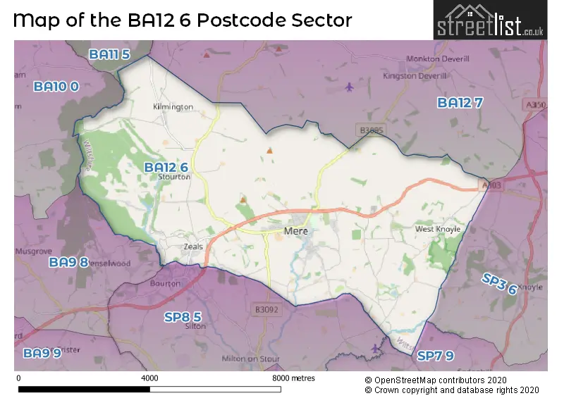
The BA12 6 postcode sector lies where the three counties of Somerset, Wiltshire, and Dorset meet.
Did you know? According to the 2021 Census, the BA12 6 postcode sector is home to a bustling 4,397 residents!
Given that each sector allows for 400 unique postcode combinations. Letters C, I, K, M, O and V are not allowed in the last two letters of a postcode. With 218 postcodes already in use, this leaves 182 units available.
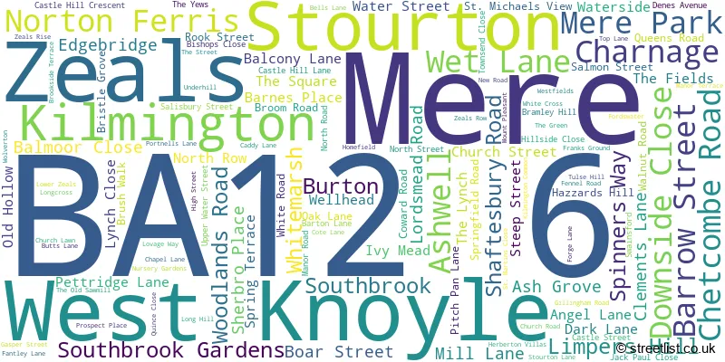
The largest settlement in the BA12 6 postal code is Mere followed by Zeals, and Kilmington.
The BA12 6 Postcode shares a border with BA9 8 (Charlton Musgrove, Pen Selwood, Holton), BA10 0 (BRUTON, North Brewham, South Brewham), BA11 5 (FROME, Witham Friary, Trudoxhill), BA12 7 (Corsley, Sutton Veny, Horningsham), SP3 6 (Tisbury, East Knoyle, Hindon), SP7 9 (Motcombe, Donhead St. Mary, Semley) and SP8 5 (Bourton, East Stour, GILLINGHAM).
The sector is within the post town of WARMINSTER.
BA12 6 is a postcode sector within the BA12 postcode district which is within the BA Bath postcode area.
The Royal Mail delivery office for the BA12 6 postal sector is the Mere Scale Payment Delivery Office and Warminster Delivery Office.
The area of the BA12 6 postcode sector is 22.75 square miles which is 58.93 square kilometres or 14,562.95 square acres.
The BA12 6 postcode sector is crossed by the A303 Major A road.

Map of the BA12 6 Postcode Sector
Explore the BA12 6 postcode sector by using our free interactive map.
| B | A | 1 | 2 | - | 6 | X | X |
| B | A | 1 | 2 | Space | 6 | Letter | Letter |
Official List of Streets
Mere (79 Streets)
Stourton (6 Streets)
Zeals (16 Streets)
Unofficial Streets or Alternative Spellings
GILLINGHAM
BAY ROADMilton On Stour
MAPPERTON HILLBourton
FANTLEY LANE FORGE LANE HIGH STREETPen Selwood
COOMBE STREETWeather Forecast for BA12 6
Press Button to Show Forecast for Mere
| Time Period | Icon | Description | Temperature | Rain Probability | Wind |
|---|---|---|---|---|---|
| 09:00 to 12:00 | Overcast | 8.0°C (feels like 6.0°C) | 13.00% | ENE 9 mph | |
| 12:00 to 15:00 | Cloudy | 10.0°C (feels like 8.0°C) | 17.00% | NE 11 mph | |
| 15:00 to 18:00 | Cloudy | 11.0°C (feels like 9.0°C) | 16.00% | NE 11 mph | |
| 18:00 to 21:00 | Cloudy | 10.0°C (feels like 7.0°C) | 14.00% | NNE 11 mph | |
| 21:00 to 00:00 | Light rain | 8.0°C (feels like 5.0°C) | 52.00% | NNE 11 mph |
Press Button to Show Forecast for Mere
| Time Period | Icon | Description | Temperature | Rain Probability | Wind |
|---|---|---|---|---|---|
| 00:00 to 03:00 | Heavy rain | 7.0°C (feels like 3.0°C) | 79.00% | NNE 13 mph | |
| 03:00 to 06:00 | Heavy rain | 6.0°C (feels like 3.0°C) | 86.00% | N 13 mph | |
| 06:00 to 09:00 | Heavy rain | 6.0°C (feels like 2.0°C) | 82.00% | N 11 mph | |
| 09:00 to 12:00 | Light rain | 7.0°C (feels like 4.0°C) | 57.00% | NNW 11 mph | |
| 12:00 to 15:00 | Overcast | 9.0°C (feels like 6.0°C) | 19.00% | NW 11 mph | |
| 15:00 to 18:00 | Overcast | 10.0°C (feels like 8.0°C) | 15.00% | WNW 9 mph | |
| 18:00 to 21:00 | Sunny day | 10.0°C (feels like 8.0°C) | 5.00% | W 7 mph | |
| 21:00 to 00:00 | Clear night | 6.0°C (feels like 4.0°C) | 1.00% | WSW 7 mph |
Press Button to Show Forecast for Mere
| Time Period | Icon | Description | Temperature | Rain Probability | Wind |
|---|---|---|---|---|---|
| 00:00 to 03:00 | Clear night | 4.0°C (feels like 2.0°C) | 1.00% | SW 4 mph | |
| 03:00 to 06:00 | Clear night | 3.0°C (feels like 1.0°C) | 1.00% | S 4 mph | |
| 06:00 to 09:00 | Sunny day | 6.0°C (feels like 4.0°C) | 2.00% | SSE 7 mph | |
| 09:00 to 12:00 | Partly cloudy (day) | 11.0°C (feels like 8.0°C) | 4.00% | S 13 mph | |
| 12:00 to 15:00 | Cloudy | 12.0°C (feels like 9.0°C) | 8.00% | S 16 mph | |
| 15:00 to 18:00 | Partly cloudy (day) | 12.0°C (feels like 9.0°C) | 5.00% | S 16 mph | |
| 18:00 to 21:00 | Sunny day | 11.0°C (feels like 9.0°C) | 5.00% | S 11 mph | |
| 21:00 to 00:00 | Clear night | 8.0°C (feels like 6.0°C) | 5.00% | SE 9 mph |
Press Button to Show Forecast for Mere
| Time Period | Icon | Description | Temperature | Rain Probability | Wind |
|---|---|---|---|---|---|
| 00:00 to 03:00 | Clear night | 8.0°C (feels like 6.0°C) | 4.00% | SE 9 mph | |
| 03:00 to 06:00 | Clear night | 8.0°C (feels like 5.0°C) | 5.00% | SE 9 mph | |
| 06:00 to 09:00 | Sunny day | 9.0°C (feels like 6.0°C) | 7.00% | SE 9 mph | |
| 09:00 to 12:00 | Partly cloudy (day) | 12.0°C (feels like 9.0°C) | 12.00% | SE 13 mph | |
| 12:00 to 15:00 | Cloudy | 13.0°C (feels like 11.0°C) | 16.00% | SSE 13 mph | |
| 15:00 to 18:00 | Cloudy | 14.0°C (feels like 11.0°C) | 35.00% | SE 11 mph | |
| 18:00 to 21:00 | Cloudy | 12.0°C (feels like 11.0°C) | 15.00% | SE 9 mph | |
| 21:00 to 00:00 | Partly cloudy (night) | 9.0°C (feels like 8.0°C) | 8.00% | SE 7 mph |
Schools and Places of Education Within the BA12 6 Postcode Sector
Mere School
Community school
Springfield Road, Warminster, Wiltshire, BA12 6EW
Head: Mrs Catriona Williamson
Ofsted Rating: Good
Inspection: 2022-11-09 (535 days ago)
Website: Visit Mere School Website
Phone: 01747860515
Number of Pupils: 214
Whitesheet Church of England Primary Academy
Academy sponsor led
Chapel Lane, Warminster, Wiltshire, BA12 6NL
Head: Mrs Emily Mullord
Ofsted Rating: Good
Inspection: 2021-12-02 (877 days ago)
Website: Visit Whitesheet Church of England Primary Academy Website
Phone: 01747840394
Number of Pupils: 36
House Prices in the BA12 6 Postcode Sector
| Type of Property | 2018 Average | 2018 Sales | 2017 Average | 2017 Sales | 2016 Average | 2016 Sales | 2015 Average | 2015 Sales |
|---|---|---|---|---|---|---|---|---|
| Detached | £377,750 | 20 | £360,549 | 40 | £358,948 | 30 | £360,284 | 35 |
| Semi-Detached | £259,821 | 14 | £234,485 | 14 | £207,746 | 14 | £218,500 | 19 |
| Terraced | £263,153 | 15 | £233,477 | 11 | £198,971 | 19 | £201,646 | 11 |
| Flats | £175,000 | 3 | £136,814 | 7 | £125,000 | 2 | £105,333 | 3 |
Important Postcodes BA12 6 in the Postcode Sector
BA12 6DT is the postcode for Mere Surgery, Dark Lane
BA12 6EW is the postcode for Mere First School, Springfield Road, and Mere School, Springfield Road
BA12 6EX is the postcode for Wiltshire Fire Brigade, Fire Station, White Road
BA12 6JA is the postcode for Wiltshire Council, Mere Library, Barton Lane
| The BA12 6 Sector is within these Local Authorities |
|
|---|---|
| The BA12 6 Sector is within these Counties |
|
| The BA12 6 Sector is within these Water Company Areas |
|
Tourist Attractions within the BA12 6 Postcode Area
We found 1 visitor attractions within the BA12 postcode area
| Stourhead House and Garden |
|---|
| Gardens |
| Garden |
| View Stourhead House and Garden on Google Maps |