The DD2 postcode district is a postal district located in the DD Dundee postcode area with a population of 41,829 residents according to the 2011 Scotland Census.
The area of the DD2 postcode district is 30.36 square miles which is 78.62 square kilometres or 19,428.10 acres.
Currently, the DD2 district has about 1250 postcode units spread across 5 geographic postcode sectors.
Given that each sector allows for 400 unique postcode combinations, the district has a capacity of 2,000 postcodes. With 1250 postcodes already in use, this leaves 750 units available.
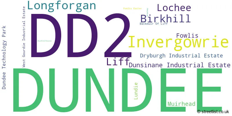
The largest settlement in the DD2 postal code is DUNDEE followed by Invergowrie, and Longforgan.
The postcode area has a boundary with The North Sea.
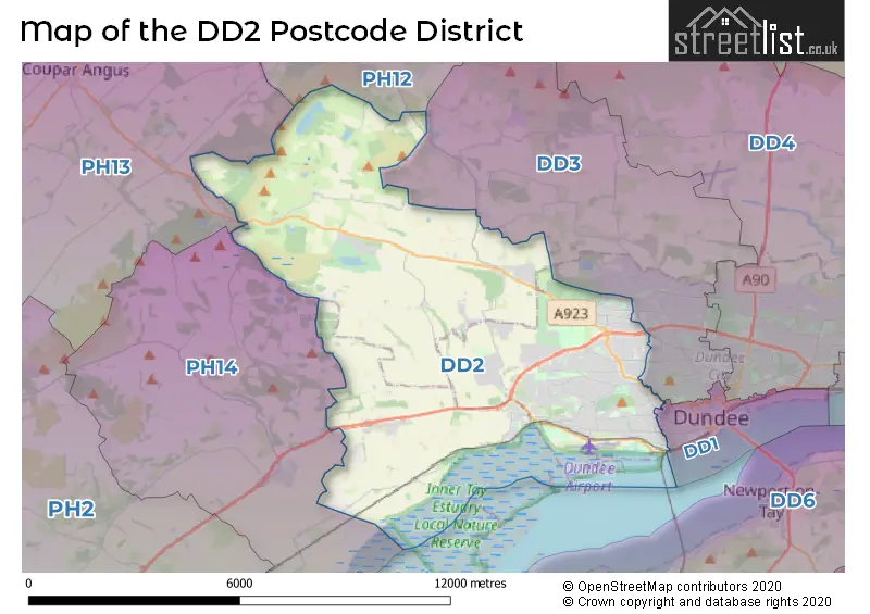
The DD2 Postcode shares a border with DD3 (DUNDEE, Auchterhouse, Strathmartine), PH14 (Inchture, Abernyte), DD1 (DUNDEE), PH12 (Meigle, Newtyle, Ardler) and PH13 (Coupar Angus, Burrelton, Kettins).
In the DD2 postcode district, the primary settlement is Dundee, located in the City of Dundee in Scotland. The most significant postal town in this area is Dundee. Other notable settlements within this district include Dundee Technology Park, Lochee, Dryburgh Industrial Estate, Dunsinane Industrial Estate, West Gourdie Industrial Estate, Auchterhouse, Backmuir Of Liff, Birkhill, Dronley, Fowlis, Fowlis Easter, Invergowrie, Liff, Longforgan, Lundie, and Muirhead. These settlements are located in various counties, including the county of Angus, Perth and Kinross, and City of Dundee.
For the district DD2, we have data on 6 postcode sectors. Here's a breakdown: The sector DD2 1, covers Dundee in City of Dundee. The sector DD2 2, covers Dundee in City of Dundee. The sector DD2 3, covers Dundee and Lochee in City of Dundee. The sector DD2 4, covers Dundee in City of Dundee. The sector DD2 5, covers Invergowrie and Longforgan in Perth and Kinross. The sector DD2 5, covers Dundee in City of Dundee. The sector DD2 5, covers Birkhill in Angus. The sector DD2 9 is non-geographic. It's often designated for PO Boxes, large organisations, or special services.

Map of the DD2 Postcode District
Explore the DD2 postcode district by using our free interactive map.
When it comes to local government, postal geography often disregards political borders. However, for a breakdown in the DD2 District: the district mostly encompasses the Dundee City (1056 postcodes), followed by the Perth and Kinross area (103 postcodes), and finally, the Angus area (101 postcodes).
Where is the DD2 Postcode District?
The postcode district DD2 is located in Dundee, which is the district town. It is nearby several towns, including Newport-on-Tay, Edinburgh, Cupar, Forfar, and Perth. The distance from DD2 to London is approximately 364.85 miles.
The district is within the post town of DUNDEE.
The sector has postcodes within the nation of Scotland.
The DD2 Postcode District is in the Angus and Dundee City region of Eastern Scotland within the Scotland.
Weather Forecast for DD2
Press Button to Show Forecast for Muirhead (Angus)
| Time Period | Icon | Description | Temperature | Rain Probability | Wind |
|---|---|---|---|---|---|
| 12:00 to 15:00 | Cloudy | 15.0°C (feels like 13.0°C) | 3.00% | E 11 mph | |
| 15:00 to 18:00 | Cloudy | 14.0°C (feels like 12.0°C) | 9.00% | E 13 mph | |
| 18:00 to 21:00 | Cloudy | 11.0°C (feels like 9.0°C) | 9.00% | E 11 mph | |
| 21:00 to 00:00 | Cloudy | 10.0°C (feels like 8.0°C) | 11.00% | E 11 mph |
Press Button to Show Forecast for Muirhead (Angus)
| Time Period | Icon | Description | Temperature | Rain Probability | Wind |
|---|---|---|---|---|---|
| 00:00 to 03:00 | Light rain shower (night) | 10.0°C (feels like 8.0°C) | 43.00% | ENE 9 mph | |
| 03:00 to 06:00 | Heavy rain shower (night) | 10.0°C (feels like 8.0°C) | 64.00% | ENE 9 mph | |
| 06:00 to 09:00 | Overcast | 11.0°C (feels like 10.0°C) | 14.00% | NE 7 mph | |
| 09:00 to 12:00 | Overcast | 13.0°C (feels like 12.0°C) | 12.00% | E 7 mph | |
| 12:00 to 15:00 | Cloudy | 15.0°C (feels like 14.0°C) | 7.00% | E 9 mph | |
| 15:00 to 18:00 | Cloudy | 16.0°C (feels like 14.0°C) | 5.00% | E 9 mph | |
| 18:00 to 21:00 | Cloudy | 13.0°C (feels like 12.0°C) | 5.00% | E 11 mph | |
| 21:00 to 00:00 | Cloudy | 11.0°C (feels like 9.0°C) | 6.00% | ENE 9 mph |
Press Button to Show Forecast for Muirhead (Angus)
| Time Period | Icon | Description | Temperature | Rain Probability | Wind |
|---|---|---|---|---|---|
| 00:00 to 03:00 | Cloudy | 11.0°C (feels like 9.0°C) | 8.00% | ENE 9 mph | |
| 03:00 to 06:00 | Fog | 10.0°C (feels like 9.0°C) | 20.00% | ENE 9 mph | |
| 06:00 to 09:00 | Cloudy | 11.0°C (feels like 9.0°C) | 15.00% | ENE 9 mph | |
| 09:00 to 12:00 | Cloudy | 13.0°C (feels like 11.0°C) | 16.00% | E 9 mph | |
| 12:00 to 15:00 | Cloudy | 14.0°C (feels like 12.0°C) | 14.00% | E 11 mph | |
| 15:00 to 18:00 | Overcast | 13.0°C (feels like 11.0°C) | 15.00% | E 11 mph | |
| 18:00 to 21:00 | Light rain | 12.0°C (feels like 10.0°C) | 40.00% | ENE 11 mph | |
| 21:00 to 00:00 | Cloudy | 11.0°C (feels like 9.0°C) | 15.00% | ENE 9 mph |
Press Button to Show Forecast for Muirhead (Angus)
| Time Period | Icon | Description | Temperature | Rain Probability | Wind |
|---|---|---|---|---|---|
| 00:00 to 03:00 | Cloudy | 11.0°C (feels like 9.0°C) | 14.00% | ENE 9 mph | |
| 03:00 to 06:00 | Overcast | 11.0°C (feels like 9.0°C) | 16.00% | ENE 9 mph | |
| 06:00 to 09:00 | Overcast | 11.0°C (feels like 10.0°C) | 17.00% | ENE 7 mph | |
| 09:00 to 12:00 | Overcast | 13.0°C (feels like 12.0°C) | 15.00% | E 7 mph | |
| 12:00 to 15:00 | Cloudy | 15.0°C (feels like 14.0°C) | 7.00% | E 7 mph | |
| 15:00 to 18:00 | Cloudy | 15.0°C (feels like 14.0°C) | 5.00% | E 9 mph | |
| 18:00 to 21:00 | Sunny day | 13.0°C (feels like 12.0°C) | 2.00% | E 9 mph | |
| 21:00 to 00:00 | Cloudy | 10.0°C (feels like 9.0°C) | 6.00% | ENE 7 mph |
Press Button to Show Forecast for Muirhead (Angus)
| Time Period | Icon | Description | Temperature | Rain Probability | Wind |
|---|---|---|---|---|---|
| 00:00 to 03:00 | Cloudy | 10.0°C (feels like 8.0°C) | 7.00% | ENE 7 mph | |
| 03:00 to 06:00 | Mist | 9.0°C (feels like 8.0°C) | 15.00% | ENE 4 mph | |
| 06:00 to 09:00 | Overcast | 10.0°C (feels like 9.0°C) | 10.00% | ENE 4 mph | |
| 09:00 to 12:00 | Overcast | 14.0°C (feels like 13.0°C) | 9.00% | ESE 7 mph | |
| 12:00 to 15:00 | Partly cloudy (day) | 16.0°C (feels like 15.0°C) | 5.00% | ESE 7 mph | |
| 15:00 to 18:00 | Partly cloudy (day) | 16.0°C (feels like 14.0°C) | 9.00% | ESE 9 mph | |
| 18:00 to 21:00 | Cloudy | 14.0°C (feels like 12.0°C) | 11.00% | E 7 mph | |
| 21:00 to 00:00 | Clear night | 11.0°C (feels like 9.0°C) | 4.00% | E 7 mph |
| Postcode Sector | Delivery Office |
|---|---|
| DD2 1 | Dundee West Delivery Office |
| DD2 2 | Dundee West Delivery Office |
| DD2 3 | Dundee West Delivery Office |
| DD2 4 | Dundee West Delivery Office |
| DD2 5 | Dundee West Delivery Office |
| D | D | 2 | - | X | X | X |
| D | D | 2 | Space | Numeric | Letter | Letter |
Current Monthly Rental Prices
| # Bedrooms | Min Price | Max Price | Avg Price |
|---|---|---|---|
| 2 | £660 | £1,240 | £942 |
| 3 | £750 | £1,675 | £1,351 |
| 5 | £2,200 | £2,250 | £2,225 |
Current House Prices
| # Bedrooms | Min Price | Max Price | Avg Price |
|---|---|---|---|
| £49,995 | £195,000 | £117,999 | |
| 1 | £57,500 | £160,000 | £88,100 |
| 2 | £70,000 | £200,000 | £133,583 |
| 3 | £90,000 | £350,000 | £233,038 |
| 4 | £245,000 | £585,000 | £387,375 |
| 5 | £199,995 | £830,000 | £521,332 |
| 6 | £500,000 | £600,000 | £541,667 |
| 7 | £795,000 | £795,000 | £795,000 |
Estate Agents who Operate in the DD2 District
| Logo | Name | Brand Name | Address | Contact Number | Total Properties |
|---|---|---|---|---|---|
 | Dundee | Rosie Fraser Real Estate | 47 Silver Birch Drive, Baldovie, Ballumbie, Dundee, DD5 3NS | 01382 699880 | 14 |
 | Dundee | Sandstone UK Property Management Solutions Ltd | 20a Whitehall Crescent, Dundee, DD1 4AU | 01382 919410 | 13 |
 | Dundee | Verdala | 250 Brook Street Broughty Ferry Dundee DD5 2AH | 01382 919405 | 7 |
 | Dundee | YOUR MOVE | 22 Whitehall Crescent, Dundee, DD1 4AU | 01382 919049 | 5 |
 | Dundee | Remax Real Estate Centre Dundee | River Court 5 West Victoria Dock Road, Dundee, DD1 3JT | 01382 919562 | 5 |