
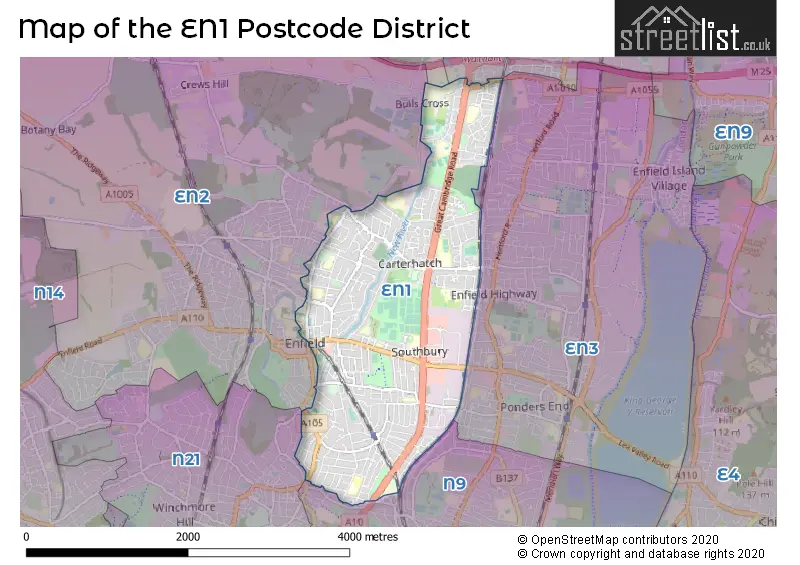
Map of the Postcode District
Explore the postcode district by using our interactive map.
Circles represent recorded crime; the larger the circle, the higher the crime rates.
Your support helps keep this site running!
If you enjoy using this website, consider buying me a coffee to help cover hosting costs.
The postcode district located in the EN Enfield postal area , EN1 has a population of 47,936 residents according to the 2021 England and Wales Census.
The area of the district is 3.09 square miles (7.99 square kilometers or 1,975.27 acres).
Where is the EN1 District?
To give you an idea where the district is located we have created the following table showing nearby towns.
Nearest Towns to EN1
| Town | Distance (miles) | Direction |
|---|---|---|
| Waltham Cross | 2.48 | NNE |
| Cheshunt | 3.38 | NNE |
| Waltham Abbey | 4.08 | ENE |
| Loughton | 5.64 | E |
| Potters Bar | 6.19 | WNW |
| Chigwell | 6.52 | ESE |
| Hoddesdon | 7.45 | NNE |
| Epping | 8.08 | ENE |
| Borehamwood | 8.83 | W |
| Hertford | 9.78 | N |
| City of London | 9.84 | S |
| Hatfield | 10.10 | NW |
| Harlow | 10.41 | NE |
| Ware | 11.01 | N |
| City of Westminster | 11.02 | SSW |
| Radlett | 11.07 | W |
| Welwyn Garden City | 11.92 | NNW |
| Bushey | 12.94 | W |
| St Albans | 13.56 | WNW |
| Chipping Ongar | 13.74 | ENE |
The post town for this district is ENFIELD.
Postcode Information for District EN1 (Total Geographical Postcodes: 917)
| Location | Post Town | Sector | Number of Postcodes |
|---|---|---|---|
| ENFIELD | ENFIELD | EN1 3 | 249 |
| ENFIELD | ENFIELD | EN1 4 | 245 |
| ENFIELD | ENFIELD | EN1 1 | 223 |
| ENFIELD | ENFIELD | EN1 2 | 200 |
Retail and Shopping in EN1
Street
Town
Locality
Number of Shops
Central Postcode
View on Google Maps
BAKER STREET
ENFIELD
59
EN1 3JY
View on Google Maps
SOUTHBURY ROAD
ENFIELD
56
EN1 1YY
View on Google Maps
ST MARKS ROAD
ENFIELD
26
EN1 1BJ
View on Google Maps
MAIN AVENUE
ENFIELD
22
EN1 1DJ
View on Google Maps
CROWN ROAD
ENFIELD
21
EN1 1TH
View on Google Maps
GREAT CAMBRIDGE ROAD
ENFIELD
19
EN1 4JU
View on Google Maps
QUEEN ANNES PLACE
ENFIELD
15
EN1 2QB
View on Google Maps
SILVER STREET
ENFIELD
15
EN1 3EF
View on Google Maps
BULLSMOOR LANE
ENFIELD
13
EN1 4SB
View on Google Maps
PERCIVAL ROAD
ENFIELD
13
EN1 1QU
View on Google Maps
VILLAGE ROAD
ENFIELD
8
EN1 2HB
View on Google Maps
FILLEBROOK AVENUE
ENFIELD
6
EN1 3BB
View on Google Maps
KEMPE ROAD
ENFIELD
6
EN1 4QT
View on Google Maps
| Street | Town | Locality | Number of Shops | Central Postcode | View on Google Maps |
|---|---|---|---|---|---|
| BAKER STREET | ENFIELD | 59 | EN1 3JY | View on Google Maps | |
| SOUTHBURY ROAD | ENFIELD | 56 | EN1 1YY | View on Google Maps | |
| ST MARKS ROAD | ENFIELD | 26 | EN1 1BJ | View on Google Maps | |
| MAIN AVENUE | ENFIELD | 22 | EN1 1DJ | View on Google Maps | |
| CROWN ROAD | ENFIELD | 21 | EN1 1TH | View on Google Maps | |
| GREAT CAMBRIDGE ROAD | ENFIELD | 19 | EN1 4JU | View on Google Maps | |
| QUEEN ANNES PLACE | ENFIELD | 15 | EN1 2QB | View on Google Maps | |
| SILVER STREET | ENFIELD | 15 | EN1 3EF | View on Google Maps | |
| BULLSMOOR LANE | ENFIELD | 13 | EN1 4SB | View on Google Maps | |
| PERCIVAL ROAD | ENFIELD | 13 | EN1 1QU | View on Google Maps | |
| VILLAGE ROAD | ENFIELD | 8 | EN1 2HB | View on Google Maps | |
| FILLEBROOK AVENUE | ENFIELD | 6 | EN1 3BB | View on Google Maps | |
| KEMPE ROAD | ENFIELD | 6 | EN1 4QT | View on Google Maps |
The primary settlement in the EN1 postcode district is Enfield, located in the county of Greater London, England. The most significant post town in this district is also Enfield.
When it comes to local government, postal geography often disregards political borders. However, this district intersects the following councils: the district mostly encompasses the Enfield London Boro area with a total of 980 postal codes.
The EN1 postal code covers the settlement of ENFIELD.
The EN1 Postcode shares a border with N9 (EDMONTON), EN8 (CHESHUNT, WALTHAM CROSS), EN3 (ENFIELD) and EN2 (ENFIELD).


Schools in the Sector
Bush Hill Park Primary School
Phase: Primary
Address: Bush Hill Park Primary School , Main Avenue , Bush Hill Park , Enfield
Postcode: EN1 1DS
Headteacher: Mrs Anna Theodosiou (Headteacher)
Ofsted Rating: Good
Edmonton County School
Phase: All-through
Address: Great Cambridge Road , Enfield
Postcode: EN1 1HQ
Headteacher: Dr Susan Tranter (Executive Headteacher)
Ofsted Rating: Good
George Spicer Primary School
Phase: Primary
Address: Southbury Road , Enfield
Postcode: EN1 1YF
Headteacher: Mr Dominic Spong (Headteacher)
Ofsted Rating: Good
Kingsmead School
Phase: Secondary
Address: 196 Southbury Road , Enfield
Postcode: EN1 1YQ
Headteacher: Mr David Medway (Head)
Ofsted Rating: Good
Raglan Infant School
Phase: Primary
Address: Wellington Road , Enfield
Postcode: EN1 2NS
Headteacher: Mr Martin Kelsey-Hatton (Headteacher)
Ofsted Rating: Good
The Raglan Junior School
Phase: Primary
Address: Raglan Road , Bush Hill Park , Enfield
Postcode: EN1 2RG
Headteacher: Mr Martin Kelsey-Hatton (Headteacher)
Ofsted Rating: Good
Silverways School
Phase: Not applicable
Address: St Andrew's Parish Centre , Silver Street , Enfield
Postcode: EN1 3EG
Headteacher: Mrs Jeanette Maynard ()
Ofsted Rating: Good
Chace Community School
Phase: Secondary
Address: Churchbury Lane , Enfield
Postcode: EN1 3HQ
Headteacher: Ms Tanya Douglas (Headteacher)
Ofsted Rating: Good
Suffolks Primary School
Phase: Primary
Address: Brick Lane , Enfield
Postcode: EN1 3PU
Headteacher: Mrs Andrea Cassius (Headteacher)
Ofsted Rating: Good
Bishop Stopford's School
Phase: Secondary
Address: Brick Lane , Enfield
Postcode: EN1 3PU
Headteacher: Mrs Tammy Day (Headteacher)
Ofsted Rating: Good
St Andrew's CofE Primary School
Phase: Primary
Address: 116 Churchbury Lane , Enfield
Postcode: EN1 3UL
Headteacher: Miss Cathryn Mann (Headteacher)
Ofsted Rating: Good
Russet House School
Phase: Not applicable
Address: 11 Autumn Close , Enfield
Postcode: EN1 4JA
Headteacher: Ms Gilly Taylor (Headteacher)
Ofsted Rating: Good
Carterhatch Junior School
Phase: Primary
Address: Carterhatch Lane , Enfield
Postcode: EN1 4JY
Headteacher: Mr Paul Barraclough (Headteacher)
Ofsted Rating: Good
Carterhatch Infant School
Phase: Primary
Address: Carterhatch Lane , Enfield
Postcode: EN1 4JY
Headteacher: Sarah Clements (Joint Headteachers)
Ofsted Rating: Good
Carterhatch Junior School
Phase: Primary
Address: Carterhatch Lane , Enfield
Postcode: EN1 4JY
Headteacher: Ms Helen McGovern (Headteacher)
Ofsted Rating: Good
St Ignatius College
Phase: Secondary
Address: Turkey Street , Enfield
Postcode: EN1 4NP
Headteacher: Mrs Mary O'Keeffe (Headteacher)
Ofsted Rating: Good
Honilands Primary School
Phase: Primary
Address: Lovell Road , London Borough of Enfield , Lovell Road Enfield , London
Postcode: EN1 4RE
Headteacher: Mr James Irvine (Headteacher)
Ofsted Rating: Good
Orchardside School
Phase: Not applicable
Address: 230 Bullsmoor Lane , Enfield
Postcode: EN1 4RL
Headteacher: Ms Celeste Fay (Headteacher)
Ofsted Rating: Good
Capel Manor Primary School
Phase: Primary
Address: Bullsmoor Lane , Enfield
Postcode: EN1 4RL
Headteacher: Mrs Marianne Enchill-Balogun (Headteacher)
Ofsted Rating: Good
Capel Manor College
Phase: 16 plus
Address: Bullsmoor Lane , Enfield
Postcode: EN1 4RQ
Headteacher: Mr Peter Brammall (Principal)
Ofsted Rating: Requires improvement
Worcesters Primary School
Phase: Primary
Address: Goat Lane , Enfield
Postcode: EN1 4UF
Headteacher: Mrs Karen Jaeggi (Headteacher)
Ofsted Rating: Outstanding
Longlands Primary School and Nursery
Phase: Primary
Address: Nunsbury Drive , Turnford , Broxbourne
Postcode: EN10 6AG
Headteacher: Miss Ashleigh Calver (Headteacher)
Ofsted Rating: Outstanding
Wormley CofE Primary School
Phase: Primary
Address: Cozens Lane East , Wormley , Wormley Primary School, Cozens Lane East , Broxbourne
Postcode: EN10 6QA
Headteacher: Mrs Tracy Gaiteri (Headteacher)
Ofsted Rating: Good
Broxbourne CofE Primary School
Phase: Primary
Address: Mill Lane , Broxbourne
Postcode: EN10 7AY
Headteacher: Mr Paul Miller (Headteacher)
Ofsted Rating: Outstanding
The Broxbourne School
Phase: Secondary
Address: Badgers Walk , Broxbourne
Postcode: EN10 7FU
Headteacher: Ms Paula Humphreys (Headteacher)
Ofsted Rating: Good
Rivers Education Support Centre
Phase: Not applicable
Address: Old Essex Road , Hoddesdon
Postcode: EN11 0AA
Headteacher: Mr Andrew Stuart ()
Ofsted Rating: Good
Rye Park Nursery School
Phase: Nursery
Address: Walton Road , Walton Road , Hoddesden
Postcode: EN11 0LN
Headteacher: Mrs Debbie Penwill (Headteacher)
Ofsted Rating: Outstanding
The John Warner School
Phase: Secondary
Address: Stanstead Road , Hoddesdon
Postcode: EN11 0QF
Headteacher: Rachel Brindley (Executive Headteacher)
Ofsted Rating: Special Measures
Forres Primary School
Phase: Primary
Address: Stanstead Road , Hoddesdon
Postcode: EN11 0RW
Headteacher: Mr Gavin Douglas (Headteacher)
Ofsted Rating: Requires improvement
St Cross Catholic Primary School
Phase: Primary
Address: Upper Marsh Lane , St. Cross Rc Primary School , Hoddesdon
Postcode: EN11 8BN
Headteacher: Mrs Joanne Walsh (Headteacher)
Ofsted Rating: Good
St Augustine's Catholic Primary School
Phase: Primary
Address: Riversmead , Hoddesdon
Postcode: EN11 8DP
Headteacher: Mrs Gillian Napier (Headteacher)
Ofsted Rating: Good
St Catherine's Hoddesdon CofE Primary School
Phase: Primary
Address: Haslewood Avenue , Hoddesdon
Postcode: EN11 8HT
Headteacher: Mrs Dorothy Marlow (Headteacher)
Ofsted Rating: Good
Sheredes School
Phase: Secondary
Address: Cock Lane , Hoddesdon
Postcode: EN11 8JY
Headteacher: Mr Ced De La Croix (Headteacher)
Ofsted Rating: Serious Weaknesses
Robert Barclay Academy
Phase: Secondary
Address: Cock Lane , Hoddesdon
Postcode: EN11 8JY
Headteacher: Mr Ced de la Croix ()
Ofsted Rating: Good
Sheredes Primary School
Phase: Primary
Address: Benford Road , Hoddesdon
Postcode: EN11 8LL
Headteacher: Mrs Mary Childs (Headteacher)
Ofsted Rating: Outstanding
Westfield Community Primary School
Phase: Primary
Address: Westfield Road , Hoddesdon
Postcode: EN11 8RA
Headteacher: Mrs Kelly Gradwell (Headteacher)
Ofsted Rating: Good
Roselands Primary School
Phase: Primary
Address: High Wood Road , Hoddesdon
Postcode: EN11 9AR
Headteacher: Mrs J Carson (Headteacher)
Ofsted Rating: Good
Roselands Primary School
Phase: Primary
Address: High Wood Road , Hoddesdon
Postcode: EN11 9AR
Headteacher: Mrs J Carson (Headteacher)
Ofsted Rating: Good
The Cranbourne Primary School
Phase: Primary
Address: Bridleway North , Hoddesdon
Postcode: EN11 9PP
Headteacher: Mrs Rachel Semark (Headteacher)
Ofsted Rating: Good
The Cranbourne Primary School
Phase: Primary
Address: Bridleway North , Hoddesdon
Postcode: EN11 9PP
Headteacher: Mrs Rachel Semark (Headteacher)
Ofsted Rating: Good
Stations in the Sector
Bush Hill Park
CRS Code: BHK
Operator: LO
Line: Lea Valley lines
Company: London Overground
Enfield Town
CRS Code: ENF
Operator: LO
Line: Lea Valley lines
Company: London Overground
Accessable Motorway Junctions
M25 J25
Average Driving Time from within the district: 4.81
Average Driving Distance: 2.71
Number of Postcodes that can access the Motorway Junction: 981
M25 J26
Average Driving Time from within the district: 8.31
Average Driving Distance: 6.30
Number of Postcodes that can access the Motorway Junction: 981
M25 J24
Average Driving Time from within the district: 8.88
Average Driving Distance: 6.13
Number of Postcodes that can access the Motorway Junction: 981
M25 J23
Average Driving Time from within the district: 10.40
Average Driving Distance: 7.28
Number of Postcodes that can access the Motorway Junction: 267
A1(M) J1
Average Driving Time from within the district: 10.67
Average Driving Distance: 7.66
Number of Postcodes that can access the Motorway Junction: 71
M11 J5
Average Driving Time from within the district: 15.43
Average Driving Distance: 10.64
Number of Postcodes that can access the Motorway Junction: 732
Weather Forecast for Enfield
| Time Period | Icon | Description | Temperature | Rain Probability | Wind |
|---|---|---|---|---|---|
| 12:00 to 15:00 | Cloudy | 15.0°C (feels like 13.0°C) | 8.00% | SW 11 mph | |
| 15:00 to 18:00 | Cloudy | 15.0°C (feels like 15.0°C) | 7.00% | SW 7 mph | |
| 18:00 to 21:00 | Clear night | 13.0°C (feels like 13.0°C) | 0.00% | SW 4 mph | |
| 21:00 to 00:00 | Clear night | 11.0°C (feels like 11.0°C) | 0.00% | WSW 4 mph |
| Time Period | Icon | Description | Temperature | Rain Probability | Wind |
|---|---|---|---|---|---|
| 00:00 to 03:00 | Clear night | 10.0°C (feels like 10.0°C) | 3.00% | SW 4 mph | |
| 03:00 to 06:00 | Fog | 9.0°C (feels like 9.0°C) | 14.00% | SW 2 mph | |
| 06:00 to 09:00 | Fog | 9.0°C (feels like 9.0°C) | 17.00% | SSW 2 mph | |
| 09:00 to 12:00 | Fog | 11.0°C (feels like 10.0°C) | 14.00% | S 4 mph | |
| 12:00 to 15:00 | Cloudy | 15.0°C (feels like 14.0°C) | 4.00% | SSW 7 mph | |
| 15:00 to 18:00 | Cloudy | 16.0°C (feels like 15.0°C) | 5.00% | S 7 mph | |
| 18:00 to 21:00 | Clear night | 13.0°C (feels like 12.0°C) | 0.00% | S 7 mph | |
| 21:00 to 00:00 | Clear night | 11.0°C (feels like 10.0°C) | 0.00% | SSE 7 mph |
| Time Period | Icon | Description | Temperature | Rain Probability | Wind |
|---|---|---|---|---|---|
| 00:00 to 03:00 | Clear night | 11.0°C (feels like 9.0°C) | 0.00% | SE 7 mph | |
| 03:00 to 06:00 | Clear night | 10.0°C (feels like 8.0°C) | 0.00% | SE 7 mph | |
| 06:00 to 09:00 | Clear night | 10.0°C (feels like 8.0°C) | 1.00% | SE 9 mph | |
| 09:00 to 12:00 | Sunny day | 12.0°C (feels like 10.0°C) | 1.00% | SSE 9 mph | |
| 12:00 to 15:00 | Partly cloudy (day) | 15.0°C (feels like 13.0°C) | 1.00% | SSE 13 mph | |
| 15:00 to 18:00 | Partly cloudy (day) | 16.0°C (feels like 14.0°C) | 1.00% | S 11 mph | |
| 18:00 to 21:00 | Clear night | 14.0°C (feels like 13.0°C) | 3.00% | SSE 9 mph | |
| 21:00 to 00:00 | Clear night | 14.0°C (feels like 13.0°C) | 7.00% | SSE 11 mph |
| Time Period | Icon | Description | Temperature | Rain Probability | Wind |
|---|---|---|---|---|---|
| 00:00 to 03:00 | Partly cloudy (night) | 14.0°C (feels like 13.0°C) | 19.00% | S 11 mph | |
| 03:00 to 06:00 | Light rain shower (night) | 14.0°C (feels like 12.0°C) | 36.00% | S 11 mph | |
| 06:00 to 09:00 | Cloudy | 12.0°C (feels like 11.0°C) | 13.00% | SSW 9 mph | |
| 09:00 to 12:00 | Partly cloudy (day) | 12.0°C (feels like 11.0°C) | 8.00% | SSW 9 mph | |
| 12:00 to 15:00 | Partly cloudy (day) | 14.0°C (feels like 12.0°C) | 10.00% | SSW 11 mph | |
| 15:00 to 18:00 | Partly cloudy (day) | 13.0°C (feels like 11.0°C) | 11.00% | SSW 11 mph | |
| 18:00 to 21:00 | Clear night | 11.0°C (feels like 9.0°C) | 6.00% | SSW 11 mph | |
| 21:00 to 00:00 | Clear night | 10.0°C (feels like 7.0°C) | 1.00% | SW 9 mph |
| Time Period | Icon | Description | Temperature | Rain Probability | Wind |
|---|---|---|---|---|---|
| 00:00 to 03:00 | Clear night | 9.0°C (feels like 6.0°C) | 1.00% | SW 9 mph | |
| 03:00 to 06:00 | Clear night | 8.0°C (feels like 6.0°C) | 1.00% | SW 9 mph | |
| 06:00 to 09:00 | Clear night | 8.0°C (feels like 6.0°C) | 2.00% | SSW 9 mph | |
| 09:00 to 12:00 | Sunny day | 10.0°C (feels like 8.0°C) | 7.00% | SW 11 mph | |
| 12:00 to 15:00 | Cloudy | 12.0°C (feels like 10.0°C) | 11.00% | SW 13 mph | |
| 15:00 to 18:00 | Cloudy | 13.0°C (feels like 11.0°C) | 14.00% | SW 11 mph | |
| 18:00 to 21:00 | Clear night | 11.0°C (feels like 9.0°C) | 9.00% | SW 11 mph | |
| 21:00 to 00:00 | Clear night | 11.0°C (feels like 9.0°C) | 5.00% | SW 9 mph |
| Postal Sector | Delivery Office |
|---|---|
| EN1 1 | Enfield Delivery Office |
| EN1 2 | Enfield Delivery Office |
| EN1 3 | Enfield Delivery Office |
| EN1 4 | Enfield Delivery Office |
| E | N | 1 | - | X | X | X |
| E | N | 1 | Space | Numeric | Letter | Letter |
Street List for the EN1 District
Current Monthly Rental Prices
| # Bedrooms | Min Price | Max Price | Avg Price |
|---|---|---|---|
| £800 | £1,300 | £1,120 | |
| 1 | £899 | £1,600 | £1,299 |
| 2 | £1,500 | £1,800 | £1,638 |
| 3 | £1,850 | £3,350 | £2,277 |
| 4 | £2,000 | £2,500 | £2,285 |
| 5 | £3,990 | £3,990 | £3,990 |
Current House Prices
| # Bedrooms | Min Price | Max Price | Avg Price |
|---|---|---|---|
| £10,000 | £3,100,000 | £679,857 | |
| 1 | £160,000 | £349,995 | £254,554 |
| 2 | £222,500 | £600,000 | £374,392 |
| 3 | £325,000 | £1,000,000 | £541,609 |
| 4 | £499,995 | £1,500,000 | £722,722 |
| 5 | £700,000 | £1,995,000 | £991,000 |
| 6 | £760,000 | £1,375,000 | £1,067,500 |
Estate Agents
| Logo | Name | Brand Name | Address | Contact Number |
|---|---|---|---|---|
 | Enfield Town | Kings Group | 25, Silver Street, Enfield, EN1 3EF | 020 3869 0917 |
 | Enfield Town | Equity Estate Agents | 64 Church Street, Enfield, EN2 6AX | 020 3834 8371 |
 | Enfield | Lanes | 35 Church Street, Enfield, EN2 6AJ | 020 3835 4508 |
 | Enfield | Grange Homes Estate Agents | 12 Oakwood Parade, Enfield, London, EN1 2PX | 020 3909 8937 |
 | Enfield - Sales | Atkinsons Residential | 59 Lancaster Road Enfield EN2 0BU | 020 8366 0261 |
Yearly House Price Averages for the District
| Type of Property | 2018 Average | 2018 Sales | 2017 Average | 2017 Sales | 2016 Average | 2016 Sales | 2015 Average | 2015 Sales |
|---|---|---|---|---|---|---|---|---|
| Detached | £700,000 | 5 | £811,417 | 15 | £733,000 | 6 | £902,500 | 4 |
| Semi-Detached | £536,001 | 70 | £522,759 | 92 | £515,502 | 101 | £493,542 | 115 |
| Terraced | £447,789 | 203 | £438,476 | 235 | £415,111 | 243 | £375,621 | 284 |
| Flats | £283,624 | 155 | £282,037 | 185 | £277,879 | 259 | £269,451 | 286 |